
3:30 PM | *Powerful mid-week coastal storm to bring significant rain, wind to the Northern Mid-Atlantic/NE US and even snow can fall in the higher elevations of New England*
Paul Dorian

An upper-level low takes on a “negative” tilt to the orientation of its trough axis and this will help to spawn a powerful storm in the Northeast US; courtesy NOAA, tropicaltidbits.com
Overview
A vigorous upper-level low will drop southeastward across the Great Lakes on Wednesday and will help to set off the formation of a powerful coastal low along the east coast. This low will intensify on Wednesday and begin to impact the Mid-Atlantic region with significant rainfall – something that hasn’t been seen much in recent weeks. The storm will continue to intensify as it rides up along the Northeast US coastline late Wednesday into Wednesday night bringing with it heavy rainfall, strong winds and ultimately, even a changeover to snow in some of the higher elevations of New England. Following the storm, winds will be quite strong on Thursday and temperatures will struggle to escape the 50’s in much of the Mid-Atlantic and Northeast US.
12Z Euro forecast map for Wednesday evening with a strong storm near the Mid-Atlantic coastline; courtesy ECMWF, WSI, Inc.
Details
It has been awhile since the DC-to-Philly-to-NYC-to-Boston corridor has received a significant rainfall, but that is on the table for Wednesday into Wednesday night. As an upper-level low drops southeastward across the Great Lakes on Wednesday, low pressure will begin to intensify near the Mid-Atlantic coastline. Rain will break out in the DC-to-NYC corridor on Wednesday and some of the rain can be heavy at times. There will be an increasing impact from this storm as one moves northeast along the I-95 corridor with more rainfall amounts, for example, likely in NYC than DCA, but all areas will receive some soaking rain.

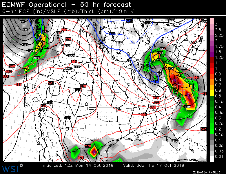
12Z Euro forecast map for Thursday morning with a strong storm along the New England coastline; courtesy ECMWF, WSI, Inc.
As the storm intensifies later Wednesday into Wednesday night, winds will pick up in intensity; especially, along coastal sections from Long Island to New England. The upper-level feature will take on a “negative tilt” to its trough axis by late Wednesday night and this will help to generate this powerful storm system. The higher elevation locations of Vermont and New Hampshire could end up seeing a changeover to snow with this system by Wednesday night as some colder air wraps around. Following the storm, it’ll be a windy and cool day on Thursday in the Mid-Atlantic region and Northeast US with strong wind gusts possible and temperatures perhaps confined to the 50’s in much of the area for afternoon highs.
Meteorologist Paul Dorian
Perspecta, Inc.
perspectaweather.com
Video discussion: