
11:00 AM (Friday) | **November looks colder-than-normal in the Mid-Atlantic/NE US following “pattern-changing” frontal passage**
Paul Dorian

06Z GEFS forecast of 850 mb temperature anomalies averaged over a 5-day period (days 6-10) with much colder-than-normal conditions extending from the Northern Plains to the NE US; map courtesy NOAA, tropicaltidbits.com
Overview
Every once in awhile there is a frontal passage that not only brings about a change in air mass for the short-term, but it can be associated with a longer-term pattern change and that looks to be the case with the powerful cold front that blasted through the Mid-Atlantic region and northeast US last night. In this particular case, the frontal passage happened to occur right around the transition from October-to-November and the overall temperature pattern indeed looks to me like it’ll flip across the nation. In October, temperatures were generally above-normal in the eastern US and below-normal in the western can central states - and in some cases significantly so. All signs point to a flip of this pattern in November with colder-than-normal weather for the Mid-Atlantic/NE US/Midwest/Great Lakes and warmer-than-normal conditions in the western part of the country.
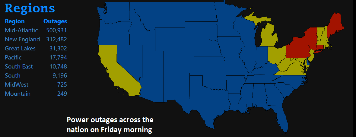
Numerous customers are without power today in the Mid-Atlantic/NE US as a result of the passage of the powerful cold front last night; map courtesy poweroutages.us
Recap of the week’s unusual early season cold wave and last night’s strong frontal passage in the east
There was record-breaking cold for the much of the week across the western and central part of the nation and in many spots significant accumulating snow fell as well. Many of the records that fell in this unusual early season cold spell were for “daily” low temperatures, but there were also a significant number of locations that experienced “monthly” low temperature records as well. A sampling follows of some locations that experienced their lowest temperature ever recorded in the month of October: Merced, CA, Garden City, KS, San Luis Obispo, CA, Rock Springs, WY, Jackson Hole, WY, Vernal, UT, Grand Junction, CO, Idaho Falls, ID, Lander, WY and Salt Lake City, UT. Furthermore, many sites in the central and western US recorded their coldest October ever including Rapid City, SD and Spokane, WA,

There were hundreds of high wind reports associated with last night’s squall line from New England to the SE US; map courtesy NOAA/SPC
Perhaps the most amazing temperature recorded in this unusual cold spell took place earlier this week in the remote observing station of Peter Sinks, Utah. Peter Sinks is a natural sinkhole in the northern part of Utah at an elevation of around 8000 feet and is known for its highly localized effects. Nonetheless, the unofficial overnight low temperature of -43.6 ºF recorded on Wednesday morning was pretty amazing for this time of year and perhaps the lowest temperature ever recorded in the Lower 48 during the month of October. Nearby Salt Lake City, Utah provided some supporting evidence of the extreme cold as it set a low temperature record of 14 ºF for the date and records there go all the way back to 1874.

Temperature anomalies at 2-meters for the month of October. Map courtesy Weather Bell Analytics, NOAA
The cold front representing the leading edge of this cold air mass blasted through the Mid-Atlantic region and NE US last night. While the air mass was significantly modified compared to the extreme cold experienced out west earlier in the week, temperatures around here have dropped sharply compared to the recent unusual warmth. A squall line formed late yesterday along the frontal boundary zone and extended from the New England-to-Florida as it headed to the eastern seaboard.

One tornado has been confirmed from last night’s squall line near Glen Mills in Delaware County PA; source NOAA/NWS
Torrential downpours associated with strong-to-severe thunderstorms marked the arrival of the squall and 50-60 mph wind gusts resulted in more than 500,000 customers this morning without power in the Mid-Atlantic/NE US. Winds will continue to gust past 40 mph in many areas through the mid-day hours, but should finally diminish later in the day. This will set us up for excellent radiational cooling conditions in the overnight hours (i.e., clear skies, calm) and many spots will bottom out near the freezing mark for the first time this season. Another widespread freezing event is possible in the Mid-Atlantic/NE US late Sunday night/early Monday as radiational cooling conditions will be excellent once again.

06Z GEFS forecast of 850 mb temperature anomalies averaged over a 5-day period (days 11-15) with colder-than-normal conditions still extending from the Northern Plains to the NE US; map courtesy NOAA, tropicaltidbits.com
November outlook for temperatures
The month of October featured warmer-than-normal conditions in the eastern US (e.g., Philly at +3.7, DCA at +4.6) and colder-than-normal weather across most of the western and central part of the nation – and in some cases it was significantly below-normal. This overall pattern looks like it may flip for the month of November and the pattern change got underway last night with the passage of the strong cold frontal system.

The days 6-10 500 mb height anomaly pattern features a polar jet stream flow from central Canada into the Mid-Atlantic/NE US and this type of “cold” flow should dominate in November; map courtesy NOAA, tropicaltidbits.com
For the next couple of weeks, it appears the polar jet stream will consistently flow in a NW-to-SE fashion the south-central part of Canada to the Great Lakes and into the Mid-Atlantic/NE US. In fact, this type of upper-air pattern that will allow for the movement of colder-than-normal air masses from Canada into the Mid-Atlantic/NE US on a consistent basis should dominate for much of the month of November. As a result, temperatures will often be below-normal in the Mid-Atlantic/NE US/Great Lakes/Midwest during November while the western US likely experiences warmer-than-normal conditions.
November snow?
As far as snow is concerned, there will likely be some “clipper” activity to monitor in the Mid-Atlantic/NE US during the next couple of weeks as the upper-air wind flow will push along waves of energy from Canada into the US. In addition, there are signs for a possible southern storm by late next week while the northern US remains quite cold anchored by Canadian high pressure - we will have to keep an eye on this. As a reminder, there was indeed a significant snow event last winter season around the middle of November (11/15/18) for many spots north of the PA/MD border with several inches of accumulation in and around the Philly and NYC metro regions. One final note, a cold November in the Mid-Atlantic/NE US does not necessarily mean that the month of December will also be below-normal.
Meteorologist Paul Dorian
Perspecta, Inc.
perspectaweather.com
Video discussion: