
11:00 AM (Monday) | ***Arctic blast arrives on Tuesday…potential record-breaking low temperatures by early Wednesday***
Paul Dorian
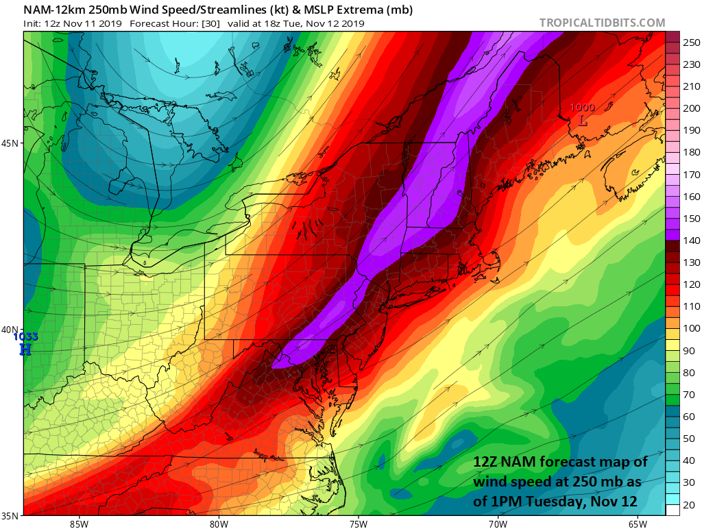
A strong jet-streak aloft may prolong the precipitation on Tuesday behind the surface cold front which could result in rain changing to snow for a brief time before the precipitation winds down; map courtesy NOAA, tropicaltidbits.com
Overview
The strong cold front representing the leading edge of a widespread Arctic air mass will pass through the DC-to-Philly-to-NYC corridor early tomorrow morning and it will likely result in a rain-changing-to-snow weather scenario. This Arctic blast is likely to result in numerous daily record lows across the central and eastern US over the next few days and, in some cases, perhaps the lowest temperatures ever recorded for this early in the season. In addition, significant accumulating snow is likely over the next 24-36 hours from Ohio/Michigan to western New York to northern New England. Rain should arrive in the DC-to-Philly-to-NYC just before daybreak and then, as colder air filters into the region, a changeover to snow for a brief time is likely not only in the immediate I-95 corridor, but ultimately all the way to the coastline. The precipitation will wind down later tomorrow and then temperatures will drop to the upper teens in many spots by early Wednesday morning – perhaps breaking low temperature records in some locations. The much colder-than-normal conditions will stick around into Thursday and then some moderation will take place at the end of the week, but temperatures will remain below-normal.

12Z NAM surface forecast map tomorrow morning indicates rain (in green) near the coast and snow (in blue) in inland areas. The rain is likely to ultimately change to snow at the coastline for a brief time as well as across interior sections of the I-95 corridor. Map courtesy NOAA, tropicaltidbits.com
Details
A surface cold front will slide through the I-95 corridor early tomorrow morning, but a strong upper-level jet streak may cause some precipitation to hang back in the cold air behind the frontal system. Temperatures are likely to peak for the day at or before daybreak on Tuesday in the DC-to-Philly-to-NYC corridor and then will drop through the 40’s and into the 30’s as the day progresses. As a result, rain that accompanies the frontal passage is likely to change to snow later tomorrow morning for a brief time as “jet-streak induced” upward motion prolongs the precipitation and there is an outside chance for minor accumulations in some spots; primarily, north of the PA/MD border. In fact, the changeover to snow may even take place all the way to coastal New Jersey and in the coastal sections of the Delmarva Peninsula as the cold air should surge eastward once it gets past the interior mountains and the jet streak aloft enhances upward motion.
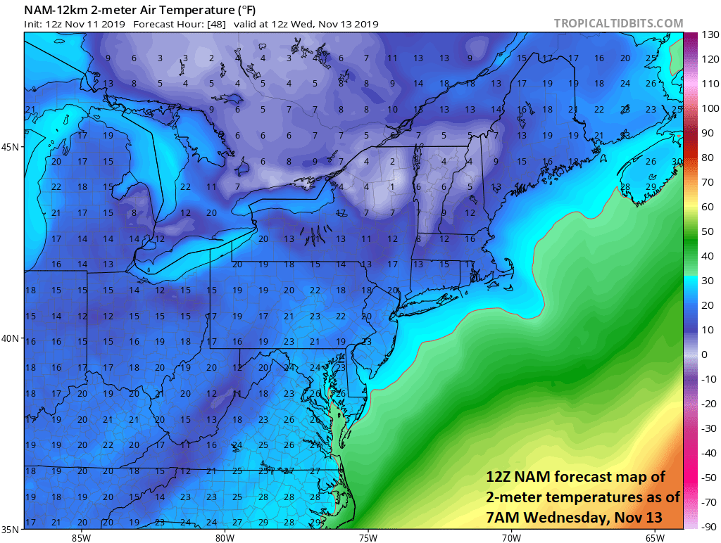
The Arctic blast will result in many suburban spots along the I-95 corridor bottoming out in the upper teens by early Wednesday morning - potential record-breaking temperatures. Map courtesy NOAA, tropicaltidbits.com
The precipitation will wind down later tomorrow and the unusual early season cold will become the main story. In fact, records could be set late tomorrow night/early Wednesday morning in many Mid-Atlantic locations with the teens likely for overnight lows in many suburban areas along the I-95 corridor. The highs on Wednesday will be confined to the lower 30’s in many parts of the DC-to-Philly-to-NYC corridor which is likely to be some of the “lowest” high temperatures ever recorded for the date of November 13th. Temperatures will drop to near 20 degrees late Wednesday night/early Thursday and then modify some as we progress to the end of the work week.
Meteorologist Paul Dorian
Perspecta, Inc.
perspectaweather.com
Video discussion: