
10:30 AM (Sunday) | **Snow and ice to have impact on travel conditions in the Mid-Atlantic region during Monday and Monday night**
Paul Dorian
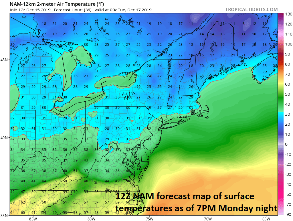
Temperatures will hover near the freezing in many spots right into the evening hours on Monday; map courtesy NOAA, tropicaltidbits.com
Overview
One storm system continues to impact the Mid-Atlantic/NE US today with brisk NW winds and another one will impact the same area from Monday into Tuesday. The next storm will intensify over the Lower Mississippi Valley early Monday and it will take a track across the central Appalachians and to the southern New England coast by Tuesday afternoon. As the storm intensifies on Monday, it will generate a west-to-east swath of precipitation that will push into the Mid-Atlantic region during the morning or mid-day hours on Monday. The air is likely to be cold enough for a period of snow and/or ice at the onset and there are likely to be some small accumulations before any changeover to rain; especially, from the northern and western suburbs of DC to areas near and north of the PA/MD border. The precipitation will intensify on Monday night and with temperatures hovering near freezing north of the PA/MD border, a significant buildup of ice is on the table.

AM commute time in DC can feature some ice and snow is likely from northern Maryland north into Pennsylvania; map courtesy NOAA, tropcialtidbits.com
Details
Low pressure will intensify over the Lower Mississippi Valley on Monday morning with a cold air mass in place across the Mid-Atlantic and NE US. This system is likely to take a track across the central Appalachians by tomorrow night and then to the southern New England coastline by Tuesday afternoon. A narrow swath of precipitation will extend quite far to the east of the low pressure system on Monday and it will reach the DC metro by AM commute time and then into Philly and NYC by mid-day or early afternoon potentially impacting the PM commutes. With the cold air in place, this initial shot of precipitation is likely to result in snow north of the PA/MD border and snow and/or ice south of there across northern Maryland, Virginia and the DC metro region.
Some light accumulations of snow and/or ice are possible in the DC metro area tomorrow morning before any changeover to ‘plain’ rain takes place later in the day and there can be up to a couple of inches of snow and ice across PA, NJ and New York City during the day on Monday. The snow and ice can impact travel conditions for the AM commute in DC and it’ll likely become troublesome for the mid-day and afternoon hours in Philly and NYC to include the evening commutes. Temperatures will likely climb above the freezing mark by the afternoon in the DC metro region, but will have a hard time all day and for much of the night north of the Mason-Dixon Line. This could result in a significant buildup of ice tomorrow night across Pennsylvania, New Jersey and in the NYC metro region as the precipitation picks up in intensity and temperatures continue to hover near freezing.
The cold front associated with this low pressure system will slide through the region later Tuesday and this will shut off the precipitation, but also act to increase the winds which could be problematic in areas that experience an icy buildup. Another cold air mass will push into the Mid-Atlantic region/NE US behind the system at mid-week and it can turn even colder by Thursday.
Meteorologist Paul Dorian
Perspecta, Inc.
perspectaweather.com