11:00 AM (Monday) | *Some snow this afternoon and early tonight in SE PA with the highest amounts confined to eastern Bucks County…central/northern NJ and NYC metro region to get hit hard*
Paul Dorian

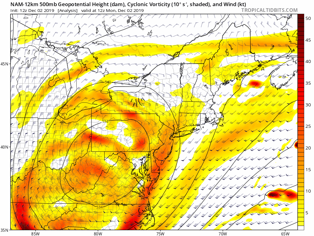
Deep upper-level low will help to generate intensification this afternoon and evening in the surface low now off the New Jersey coastline
Overview
Low pressure is located off the New Jersey coastline at mid-day and it will intensify over the next several hours as upper-level energy moves in overhead. Mixed precipitation is rotating around the surface low and will become mainly snow this afternoon and evening as colder air wraps into the system. Some snow will fall today and tonight in the Philly metro region, but the highest amounts will likely be confined to eastern Bucks County near the Delaware River and to the north and east of there which will put the northern half of New Jersey and the NYC metro region in prime zones for more significant accumulations from this western Atlantic storm. Little to no snow accumulation is likely in Chester County (SE PA) and in areas to the south of the PA/MD border.

Model forecast map for this evening has most of the snow across NJ and lesser amounts in eastern PA
Details
Mixed precipitation continues at mid-day in parts of the I-95 corridor, but as colder air wraps into the low pressure system off the Mid-Atlantic coastline, snow should become the predominate precipitation type for the afternoon and evening hours. The precipitation will actually slacken off in some areas for a few hours, but as the low pressure intensifies, the precipitation shield is likely to expand again later in the day and into the evening hours. The main area of focus for the precipitation will remain from the far northeastern suburbs of Philly (Lower Bucks County) to areas to the north and east of there across the Delaware River into central and northern NJ and the NYC metro region. Snow totals will be limited in and around Philly, but could reach several inches in central and northern NJ and the NYC metro region by the time the system pulls away later tonight. In areas south of the PA/MD border, snow showers are a threat for the afternoon and evening, but little to no snow accumulations are expected.

Surface low pressure at mid-day off the New Jersey coastline will intensify as upper-level energy moves overhead.
In terms of snowfall amounts here are some updated estimates for the Philly and NYC metro regions:
Philly: 2-5 inches possible in eastern Bucks County with a coating to an inch or two possible across Montgomery, Delaware and Philadelphia Counties; little to no snow accumulation in Chester County
NYC: 3-6 inches in the city and 6+ inches across the Hudson Valley and interior northern New Jersey.
Stay tuned…mesoscale snow bands may form later today creating the need for last minute updates of snow accumulations.
Meteorologist Paul Dorian
Perspecta, Inc.
perspectaweather.com