
10:20 AM Sunday | ***A wintry mess from late today into early Monday…strong storm by the middle of the week with significant snow accumulations possible on the front end***
Paul Dorian

Overview
Low pressure will head our way later and although it is a fairly fast-mover, it is likely to have some impact on the Mid-Atlantic region; especially, to the north and west of the big cities. Snow, ice and rain is likely in areas to the north of the PA/MD border from late today into early Monday and a mix of ice and rain is expected to the south of there. Road conditions can become slick in all areas during the nighttime hours and into early Monday morning with possible small accumulations of snow and/or ice. By the middle of the week, we’ll have to deal with a stronger storm and this one could result in significant snow accumulations for much of the Mid-Atlantic region followed by ice and rain.

Late today into early Monday
A wave of low pressure will impact the Mid-Atlantic region beginning later this afternoon and precipitation-type is a very difficult call. It looks this system will generate snow, ice and rain north of the PA/MD border and a mix of ice and rain to the south of the Mason-Dixon Line. Small snow and ice accumulations of a coating to an inch or two are possible across Pennsylvania and New Jersey from later today into early Monday and there can be a layer of ice produced to the south of the PA/MD border. Untreated road surfaces can become slick in all areas by later tonight and perhaps even lingering into the Monday AM commute. High pressure will then build into the Mid-Atlantic region during the early part of next week with seasonably cold conditions.

Mid-week storm threat
A mid-week mess is on the way for the Mid-Atlantic region that will likely include accumulating snow, ice and rain. By late Tuesday, strong high pressure will be forming to the north and northwest of the Mid-Atlantic region and there will be lots of moisture pushing northeastward from the Gulf of Mexico. This area of high pressure will lock in a cold, dense air mass in the lower levels of the atmosphere – at least for the onset of a mid-week storm system – setting us up for decent “overrunning-type” precipitation event as warmer air initially rides up and over the surface air mass. One surface low will trek from the Gulf coast states to the Great Lakes while a secondary low develops near the Mid-Atlantic coastline – quite similar to the setup early last week which resulted in snow, ice and rain for the Mid-Atlantic.
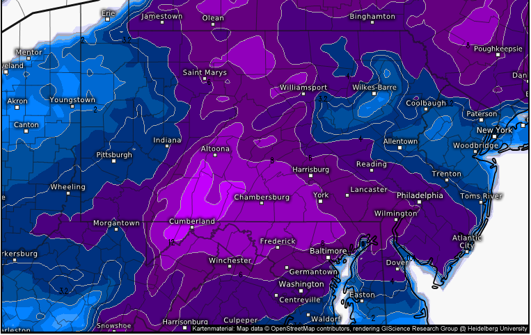

00Z Euro snow depth map by midnight Thursday; courtesy ECMWF, weather.us
Snow is likely to break out in the DC metro region early Wednesday and then expand northeastward towards Philly and NYC for the mid-day and afternoon hours respectively. By later Wednesday, milder air will advance into the region as winds turn more to the southeast and this could result in a changeover from snow to sleet and freezing rain and perhaps ultimately to plain rain by later Wednesday night. Significant accumulations of snow, however, are certainly on the table for Wednesday in the DC-to-Philly corridor and perhaps as far northeast as the NYC metro region before any changeover to sleet, freezing rain and perhaps eventually plain rain. The low pressure areas moves away later Thursday and allows for high pressure to build in from the west for Friday.
Meteorologist Paul Dorian
Perspecta, Inc.
perspectaweather.com