11:45 AM (Tuesday) | **Threat continues today for downpours and strong-to-severe thunderstorms in the Mid-Atlantic region…severe weather threat along the I-95 corridor late Thursday as well**
Paul Dorian

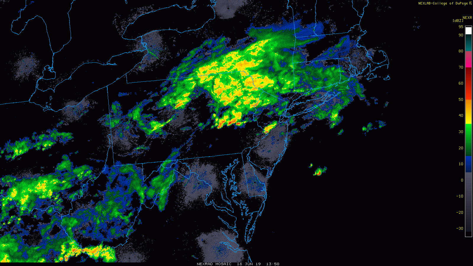
The latest radar loop features heavy showers and embedded thunderstorms across NE and east-central PA and more are intensifying over West Virginia and Ohio; courtesy NOAA, College of DuPage
Overview
A nearly stationary frontal boundary zone is combining today with tropical-like humidity and upper-level energy to generate more showers and thunderstorms in the Mid-Atlantic region and this threat for rain will continue tonight and Wednesday as well. Some of the rain that falls will be heavy and some of the storms that form later today will reach strong-to-severe levels potentially resulting in damaging wind gusts and even isolated tornadoes. Given the already well-saturated grounds, any heavy rain can quickly produce localized flooding conditions with a couple of inches possible in a short period of time. Later in the week, the combination of a strong surface low pressure system and associated cold front with powerful energy aloft will likely result in a severe weather outbreak in the I-95 corridor from later Thursday into Thursday night before a break in the action arrives for Friday and Saturday.

NOAA’s Storm Prediction Center has the Mid-Atlantic region in a “slight risk” zone for severe weather later today.
Today, tonight and Wednesday
A nearly stationary frontal boundary zone will continue to act as a focal point for showers and thunderstorms in the Mid-Atlantic region this afternoon and tonight. There has already been heavy rainfall this morning across the northern Mid-Atlantic (e.g., northern PA, northern NJ, NYC metro region) and some radar echoes are headed towards Bucks and Montgomery Counties in SE PA. Additionally, radar echoes are expanding in coverage across Ohio and West Virginia and it is from this region where the rainfall headed our way for later today will originate. As the upper-level energy moves overhead later today, the atmosphere will become more unstable and strong-to-severe thunderstorms could break out; especially, if any sunshine can break through the clouds to boost low-level temperatures. In areas where sun does manage to break through the clouds, it is possible that a few supercells form that are capable of producing a couple of tornadoes and damaging winds. On Wednesday, the threat for severe weather may diminish somewhat, but there can still be some heavy rainfall in the Mid-Atlantic region.

A powerful wave of energy will contribute to the threat for severe weather late Thursday/Thursday night in the Mid-Atlantic region; courtesy NOAA, tropicaltidbits.com
Severe weather threat for late Thursday
Ingredients may be coming together for a severe weather outbreak late Thursday into Thursday night for the I-95 corridor. An unusually strong low pressure system will develop over the western part of the Mid-Atlantic and a strong surface cold front will slide towards the east coast at the same time a powerful wave of energy in the upper part of the atmosphere arrives. As a result, there can be an outbreak of severe thunderstorms late on Thursday that could impact the DC-to-Philly-to-NYC corridor.
Once the strong cold front clears the coast by early Friday, the threat for rain will end, but the winds will pick up noticeably from a northwesterly direction. There should be some sun on Friday and the weekend looks like it’ll get off to a promising start on Saturday with sunshine and comfortably warm conditions. More rain is destined to arrive in the Mid-Atlantic region early next week.

A strong surface low pressure system will contribute to the threat for severe weather late Thursday/Thursday night in the Mid-Atlantic region; courtesy NOAA, tropicaltidbits.com
Meteorologist Paul Dorian
Perspecta, Inc.
perspectaweather.com
Video discussion: