
12:30 PM (Monday) | *That transitional time of year with lingering tropical activity in the Atlantic Basin and cold, accumulating snow across parts of the northern and central US*
Paul Dorian

While warmer-than-normal conditions are likely to continue across much of the eastern US in coming days, colder-than-normal conditions will dominate the region from the Pacific Northwest to the Upper Midwest. Map courtesy NOAA, tropicaltidbits.com
Overview
This is the time of the year in which summer is trying to hold on at the same time winter is trying to make a statement that cold and snow is on the way. Indeed, the next week to ten days will feature tropical activity in the Atlantic Basin – Tropical Storm “Epsilon” has now formed – at the same time cold air dominates the scene from the interior Northwest to the Upper Midwest with significant accumulating snow in many parts of the northern and central US.

Tropical Storm “Epsilon” has formed over the central Atlantic with maximum sustained winds of 40 mph. Image courtesy NOAA, College of DuPage
Tropical Storm “Epsilon”
Tropical Depression #27 has now strengthened into Tropical Storm “Epsilon” in the central Atlantic and it quite likely to become a hurricane during the next few days. This latest tropical system in an active season across the Atlantic Basin has maximum sustained winds of 40 mph and is nearly stationary. Gradual strengthening is quite likely over the next few days as vertical wind shear diminishes and this suggests “Epsilon” could reach hurricane status by Wednesday night or early Thursday.

Tropical Storm “Epsilon” has formed over the central Atlantic Ocean and there are couple of other tropical waves of interest to monitor over the Caribbean Sea and Gulf of Mexico. Map courtesy NOAA/NHC
While the current motion of “Epsilon” is nearly non-existent in an area of weak steering currents, it should begin to make a move to the WNW by the middle of the week. An upper-level ridge of high pressure is likely to build over the western and central Atlantic by mid-week to the north of “Epsilon” and this system should begin to cause a movement to the WNW over the next few days. While “Epsilon” is the only tropical system currently being identified by NOAA’s National Hurricane Center, there are a couple other tropical waves that will need to be monitored in coming days over the Caribbean Sea and the Gulf of Mexico as tropical activity lingers into the end of October. One more tropical system that potentially becomes an officially named storm by the National Hurricane Center would tie this year with the 2005 tropical season for most active (i.e., number of storms) in the Atlantic Basin.
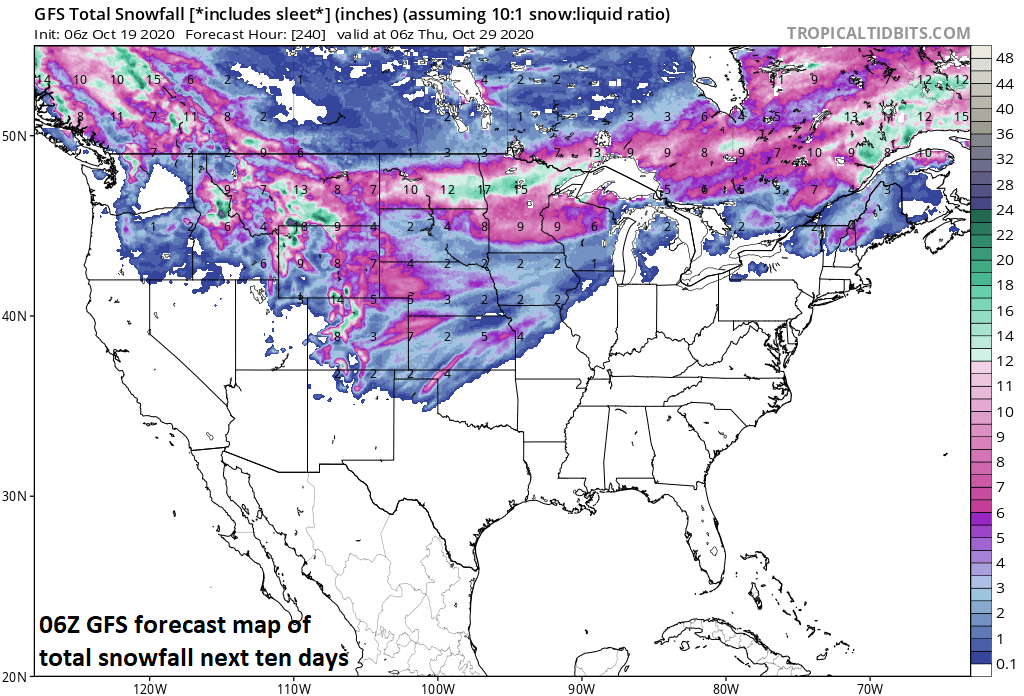
Accumulating snow will be significant in coming days from the interior Northwest to the Upper Midwest and as far south as the central Plains. Map courtesy NOAA, tropicaltidbits.com
Cold and accumulating snow
While Tropical Storm “Epsilon” meanders over the central Atlantic Ocean, colder-than-normal air has dominated the weather scene from the interior Northwest to the Northern Plains. In fact, this type of colder-than-normal weather pattern is likely to hold for the remainder of the week and will likely spread eastward to the Mid-Atlantic region and Northeast US by later next week.
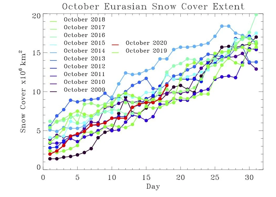
Not only is accumulating snow now being reported across portions of the northern and central US, it is beginning to pile up in Eurasia with current amounts (shown in red) in the middle of the pack of recent years for the month of October. Plot courtesy Judah Cohen (Twitter)
In addition to the cold, accumulating snow has already taken place in places like Montana and significant accumulating snow is likely to extend eastward during the next few days across the Dakotas, Minnesota and Wisconsin. In terms of specific snowfall reports, yesterday actually turned out to be the snowiest October day on record in Great Falls, Montana with 8.4 inches that bested the prior record of 6.6 inches set on October 13, 1975. The two-day total of 13.3 inches in Great Falls is its snowiest October two-day record since October 3rd and 4th, 1957 when 8.4 inches piled up. Some areas across the Dakotas, Minnesota and northern Wisconsin can receive as much as 6-12 inches of snow during the next few days as low pressure pushes out of the interior Northwest and towards the Great Lakes.
Meteorologist Paul Dorian
Perspecta, Inc.
perspectaweather.com
Follow us on Facebook, Twitter, YouTube
Video discussion: