11:30 AM (Sat) | *Significant snow threat continues for mid-week in Mid-Atlantic/NE US…potential exists for most snow in years in some areas…preceding storm to produce rain and some accumulating snow*
Paul Dorian

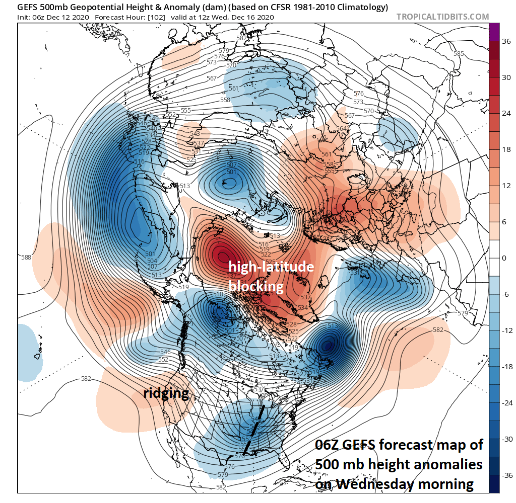
“High-latitude blocking” is likely to setup by the middle of next week in the same time period that two waves of energy will cross the south-central part of the US and move northeastward towards the Mid-Atlantic coastline. Strong high pressure is likely to build into the southeastern part of Canada and it’ll act as an important cold air source; especially, by the “mid-week event”. Map courtesy NOAA, tropicaltidbits.com
Overview
The interesting and active weather pattern of recent weeks will continue into at least the middle of the month with two storms on the table for this week in the Mid-Atlantic/Northeast. The first storm for the Mid-Atlantic/Northeast US will come on Monday and an even bigger threat comes at mid-week with the greatest potential impact. In fact, the mid-week storm could turn out to be a major snowstorm for a large part of the Mid-Atlantic/Northeast US. In the short term, the weather remains mild during the next couple of days in much of the eastern half of the nation, but a colder air mass is going to filter into the northeastern quadrant of the nation on Sunday night and Monday following the passage of a cold front - setting the stage for a very wintry week.
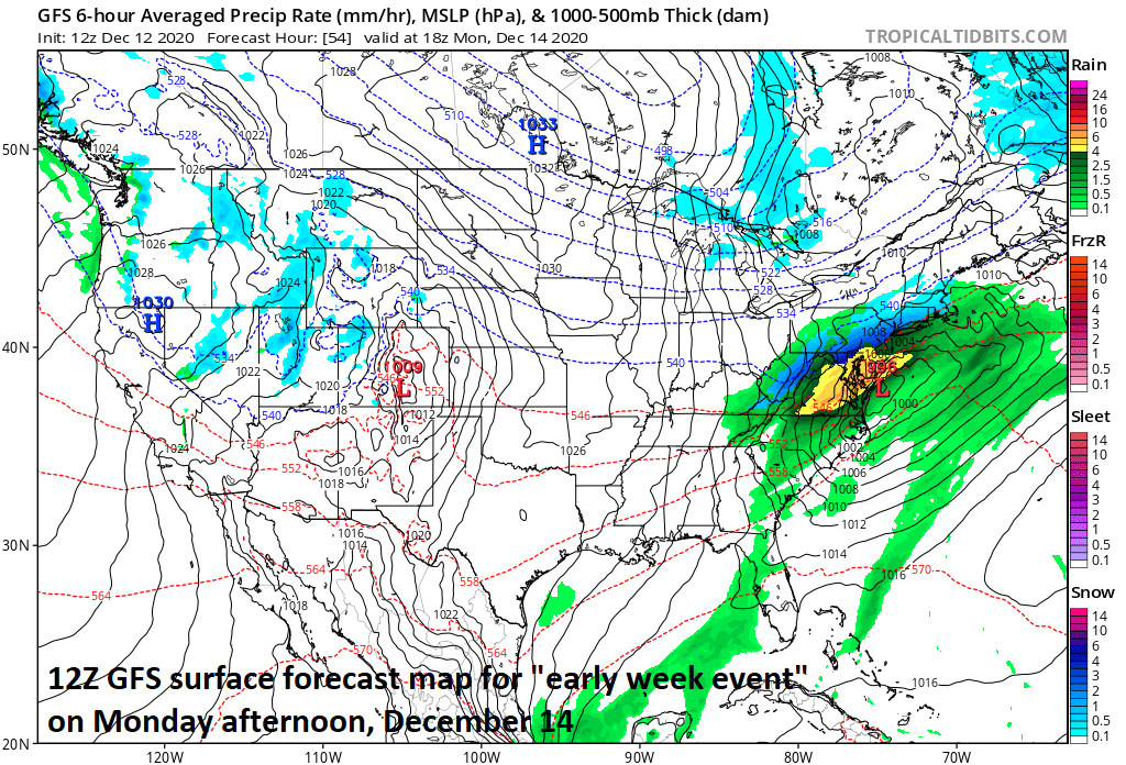
Low pressure on Monday is likely to result in a rain-changing-to-snow scenario; especially, in areas to the north and west of I-95. Map courtesy NOAA, tropicaltidbits.com
Details
Teleconnection indices such as the Arctic Oscillation (AO) and North Atlantic Oscillation (NAO) are supporting the idea of “high-latitude blocking” to get well-established by the middle of the week which, in turn, supports the idea for strong surface high pressure to build across southeastern Canada – often a necessity for receiving accumulating snowfall in the immediate I-95 corridor. In this time period, two separate waves of energy will cross the southern states and then move northeastward towards the Mid-Atlantic coastline.
In the short term, a cold front will push through the eastern states in a rather uneventful fashion later Sunday with nothing more than a shower or two. The cold front will, however, set the stage for a very winter-like pattern this week and the potential of significant snowfall in the Mid-Atlantic/Northeast US. Colder air will begin to filter into the Mid-Atlantic/Northeast US in the overnight hours on Sunday night as cold high pressure slowly builds into southeastern Canada. The high pressure system to the north will become better established by the middle of the week and become an important cold air source for the Mid-Atlantic/Northeast US when the second of two storms pushes towards the east coast.
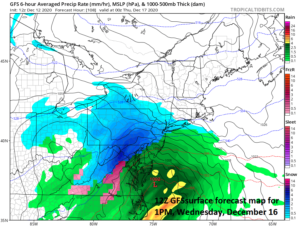
A cold air source to the north will be better established by the “mid-week event” with strong high pressure situated over southeastern Canada. Map courtesy NOAA, tropicatidbits.com
The initial storm on Monday will have “marginal” cold air to work with in the Mid-Atlantic/Northeast US likely resulting in a combination of rain and snow. The most likely scenario on Monday is for primarily a rain event to occur in the big cities and in coastal locations. However, the rain is likely to change over to accumulating snow in some of the suburbs to the north and west of I-95. In the DC metro region, the changeover to accumulating snow may be limited to the far northern and western suburbs, but in the Philly and NYC metro regions, nearby suburbs to the north and west can end up with accumulations of up to a couple of inches or so. All of this activity on Monday is likely to be just a “teaser” event when compared to what could come at mid-week.
A second disturbance will cross the southern states on Tuesday and head towards the Mid-Atlantic coastline for a mid-week rendezvous. This second system will be able to gather plenty of moisture from the Atlantic Ocean and Gulf of Mexico and the cold air source to the north (i.e., strong high pressure over southeastern Canada) will become better established by then as compared with tomorrow’s initial storm system. As a result, the chances for significant accumulating snow will increase in the Mid-Atlantic/Northeast US for the mid-week storm system. In fact, this system has the potential to produce more snow seen in several years in at least parts of the Mid-Atlantic/Northeast US where major snowstorms have been rather limited in recent years (last major one in the DC-to-Philly corridor was January 2016).
One final note, “climatology” does suggest that it is quite difficult to get significant accumulating snow in the big cities along the I-95 corridor during mid-December with the still relatively-warm sea surface temperatures in the western Atlantic Ocean. The climatological limitations this time of year are certainly something to be cognizant of; however, significant snow events have taken place in the month December. One way for such an event to take place is with “high-latitude blocking” in the upper atmosphere and strong surface high pressure anchored to the north – both of which are likely for mid-week.
Stay tuned…certainly an interesting weather pattern for the upcoming week.
Meteorologist Paul Dorian
Perspecta, Inc.
perspectaweather.com