
12:50 PM | *****Two storm threats for next week with the greatest potential impact coming at mid-week*****
Paul Dorian

“High-latitude blocking” is likely to setup by the middle of next week in the same time period that two waves of energy will cross the south-central part of the US and move northeastward towards the Mid-Atlantic coastline. Strong high pressure is likely to build into the southeastern part of Canada and it’ll act as an important cold air source; especially, by the “mid-week event”. Map courtesy NOAA, tropicaltidbits.com
Overview
The interesting and active weather pattern of recent weeks will continue into at least the middle of the month with two storm threats on the table for next week in the central and eastern US. The first storm threat for the Mid-Atlantic/Northeast US will come during the early part of next week and an even bigger threat comes at mid-week with the greatest potential impact. In fact, the mid-week storm could turn out to be a major snowstorm for a large part of the Mid-Atlantic/Northeast US. In the short term, the weather turns milder in much of the eastern half of the nation, but a colder air mass is going to filter into the northeastern quadrant during the early part of next week following the late weekend (uneventful) passage of a cold front.
Teleconnection indices such as the Arctic Oscillation (AO) and North Atlantic Oscillation (NAO) are supporting the idea of “high-latitude blocking” to get well-established by the middle of next week which, in turn, supports the idea for strong high pressure to build across southeastern Canada – always a key factor to the prospects of getting accumulating snowfall in the I-95 corridor. In this time period, two separate waves of energy will cross the southern states and then move northeastward towards the Mid-Atlantic coastline. With a cold air source building to the north across the southeastern part of Canada by the middle of next week, this type of setup could result in significant accumulating snow for at least parts of the Mid-Atlantic/Northeast US.

Teleconnection indices known as Arctic Oscillation (AO, top) and North Atlantic Oscillation (NAO, bottom) are in “negative” territory now (black) and should remain there for the foreseeable future (red). This type of pressure and temperature pattern in the high latitudes is often correlated with “high-latitude blocking” and more favorable prospects for cold air outbreaks to drop southeastward from Canada into the central and eastern US. Plots courtesy NOAA
Details
High pressure has shifted off the east coast today and milder air has funneled northeastward into the Mid-Atlantic/Northeast US and it’ll stay mild on both weekend days. In fact, temperatures should rise well up into the 50’s this weekend in much of the I-95 corridor from Philly-to-Boston and could touch the 60 degree mark for highs in the DC metro region. As a cold front slowly pushes to the east this weekend from the Midwest, there can be some rain shower activity in the Northeast US/Mid-Atlantic; however, this will not be a heavy rain event by any means. In fact, this weekend’s cold frontal passage will be rather uneventful in the Mid-Atlantic/Northeast US, but it will be the catalyst for a winter-like pattern next week and perhaps set the stage for significant accumulating snow.

The precipitation shield associated with the “early week” surface low is currently forecasted by this model to stay generally to the south of the PA/MD border. The extent of the precipitation, however, is liable to end up pushing farther to the north, but this initial system will have only marginal cold air to work with in the Mid-Atlantic region. Map courtesy NOAA, tropicaltidbits.com
Behind the late weekend cold frontal passage, colder air will begin to filter into the Mid-Atlantic/Northeast US early next week as cold high pressure slowly builds into southeastern Canada. This type of atmospheric pattern in which high pressure builds across southeastern Canada is supported by the expectation that the AO and NAO teleconnection indices will continue to remain in “negative” territory for the foreseeable future leading to “high-latitude blocking”. This high pressure system to the north may very well become an important cold air source for the Mid-Atlantic/Northeast US; especially, by the middle of next week when the second of two storms pushes towards the east coast.

A cold air source to the north will be better established by the “mid-week event” with strong high pressure situated over southeastern Canada. Map courtesy NOAA, tropicatidbits.com
At the same time the high pressure builds across southeastern Canada, two separate waves of upper-level energy will push across the southern states and each will likely take a turn to the northeast and heads towards the Mid-Atlantic coastline. Some of the current computer forecast models suggest the precipitation shield associated with the early week storm will stay generally to the south of the PA/MD border, but I believe it’ll end probably end up farther to the north. The cold air, however, will be only marginal for that initial storm system limiting the chances for significant accumulating snow in the immediate I-95 corridor; however, areas just to the north and west certainly can end up with more seen so far this season in a rain-to-snow scenario.
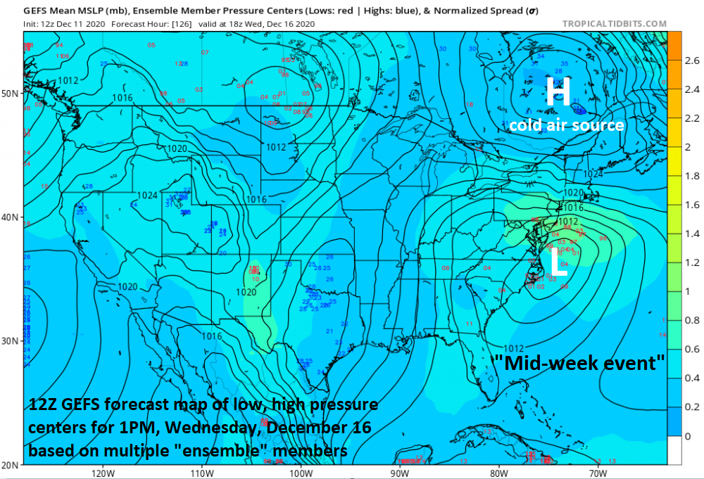
The ensemble run of the GFS for next Wednesday (i.e., “mid-week event”) shows plenty of support to the idea that there will be a well-established cold air source (strong high pressure) in southeastern Canada - a key ingredient for getting accumulating snowfall in the Mid-Atlantic/Northeast US. Map courtesy NOAA, tropicaltidbits.com
Following on its heels, another disturbance is likely to cross the southern states and head towards the eastern seaboard by the middle of next week. This system will be able to gather plenty of moisture from the Atlantic Ocean and Gulf of Mexico as it approaches the east coast and the cold air source to the north (i.e., strong high pressure over southeastern Canada) will become better established by then. As a result, the chances for significant accumulating snow will increase in the Mid-Atlantic/Northeast US for the second (mid-week) storm system. In fact, this system has the potential to produce more snow seen in several years in at least parts of the Mid-Atlantic region where major snowstorms have been rather limited to say the least.
One final note, “climatology” does suggest that it is quite difficult to get significant accumulating snow in the big cities along the DC-to-Philly-to-NYC corridor during mid-December with the still relatively-warm sea surface temperatures in the western Atlantic Ocean. However, it can definitely happen and one way for it to occur is with “high-latitude blocking” in the upper atmosphere and strong surface high pressure anchored to the north.
Stay tuned…certainly an interesting weather pattern for next week.
Meteorologist Paul Dorian
Perspecta, Inc.
perspectaweather.com
Follow us on Facebook, Twitter, YouTube
Extended video discussion on the unfolding weather pattern: