10:30 AM (Wednesday) | ***Snow showers are closing in on parts of the I-95 corridor…small accumulations in some areas with quickly developing slick spots possible on roadways***
Paul Dorian
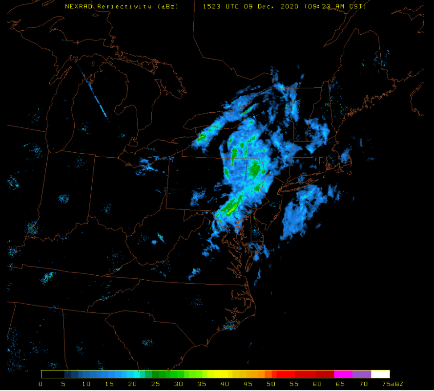
Snow showers are fairly widespread at this hour across central and northeastern PA and are pushing to the south and east. Map courtesy University of Wisconsin, NOAA
Overview
A cold front is approaching the Mid-Atlantic region and it is accompanied by a strong wave of energy in the upper part of the atmosphere and a powerful jet streak. As a result, snow showers have broken out across much of the Northeast US and Mid-Atlantic region and they are dropping southeastward at this hour towards the DC-to-Philly-NYC corridor. There is the chance for a heavier burst of snow in some spots which can cause small accumulations and quickly developing slick spots on the roadways. High pressure resumes control of the weather for the latter part of the work week.
A powerful jet streak aloft is contributing to upward motion in the Mid-Atlantic region and Northeast US and this - combined with upper-level energy - is helping to generate snow bands across parts of this region. Map courtesy NOAA, tropicaltidbits.com
Details
A potent wave of energy in the upper part of the atmosphere is pushing into the Mid-Atlantic/Northeast US and it is accompanied by a powerful jet streak at the 250 millibar level. As a result, there is strong upward motion in the region which is leading to pretty widespread snow shower activity that is now dropping south and east and right towards the DC-to-Philly-to-NYC corridor. With temperatures still near the freezing mark in many areas, any snow that develops can cause small accumulations and quickly developing slick spots on roadways. The best chance for the small accumulations will be near and north of the PA/MD border, but watch out all the way south to the northern/western suburbs of DC and also the Baltimore metro region. Late today, skies will begin to clear and it’ll stay on the chilly side and then high pressure takes control for the next couple of days with a warming trend that will last into the weekend.
Looking ahead, the overall active weather pattern will continue to present some interesting opportunities for snow and cold as we progress towards the middle of the month. The upcoming weekend will feature temperatures climbing well up into the 50’s across the DC-to-Philly-to-NYC corridor and the milder conditions will be accompanied by rain shower activity ahead of the next approaching strong cold front. Following the passage of the weekend cold front, a colder air mass will push into the Mid-Atlantic/NE US on Monday and we’ll have to watch for the possibility of a coastal storm that could form during the early or middle parts of next week.
Meteorologist Paul Dorian
Perspecta, Inc.
perspectaweather.com
Follow us on Facebook, Twitter, YouTube
Video discussion:


