
12:15 PM (Wednesday) | **An energetic cold frontal passage late tonight with brief downpours, gusty winds and perhaps a strong-to-severe thunderstorm…50 mph wind gusts possible on Thursday**
Paul Dorian

A strong cold front will barrel through the I-95 corridor late this evening likely resulting in brief downpours, gusty winds and perhaps a strong-to-severe thunderstorm; map courtesy NOAA, tropicaltidbits.com
Overview
It’ll stay relatively quiet this afternoon in the Mid-Atlantic region with nothing more than some light rain or drizzle at times to go along with mild conditions for the latter part of February. The weather story will be quite different, however, from late tonight into the day on Thursday. A very energetic weather situation is evolving for late tonight as a strong cold front will come barreling through the Mid-Atlantic region likely with brief downpours, gusty winds and perhaps a few strong-to-severe thunderstorms. It’ll turn much colder early tomorrow with stiff NW winds and these winds will actually intensify later Thursday as low pressure intensifies dramatically over the Northeast US with gusts possible to 50 mph. This incoming colder air mass will be reinforced by the early part of the weekend leading to below-normal conditions right through the upcoming weekend.

Low pressure will intensify to 979 millibars by early tomorrow afternoon according to this latest forecast from the 12Z GFS computer model. The pressure gradient across the Mid-Atlantic region will tighten on Thursday leading to the possibility of 50 mph wind gusts.; map courtesy NOAA, tropicaltidbits.com
Details
It’ll stay relatively mild and quite this afternoon in the I-95 corridor with highs of 50+ degrees and little to no wind to speak of. Low pressure is developing at mid-day over the eastern part of the Ohio Valley and it’ll intensify markedly over the next 24 hours aided by tremendous support in the upper part of the atmosphere which includes a “negatively-tilted” trough axis and a powerful jet streak. The combination of the robust upper-level energy, powerful jet streak and a strong surface cold front will likely result in brief heavy downpours late tonight and possibly some strong-to-severe thunderstorm activity. The main action with this frontal system is likely to fall in the 10PM to 4AM time period for the DC-to-Philly-to-NYC corridor. Colder air will pour into the region towards morning following the passage of the cold front and there could be a changeover to snow in upstate Pennsylvania - perhaps a few snow showers can even make it into the immediate I-95 corridor.

A “negatively-tilted” trough axis (i.e., oriented from northwest-to-southeast) will develop later tonight and this will result in enhanced upward motion in the I-95 corridor which, in turn, will increase the chance for severe weather; map courtesy NOAA, tropicaltidbits.com
On Thursday, low pressure will continue to dramatically intensify as it grinds its way into the interior part of the Northeast US. In fact, the developing low pressure system may see a drop of its central pressure by about 30 millibars over the next 24 hours from 1008 millibars early this afternoon to around 979 millibars by early tomorrow afternoon. This dramatic intensification of the surface low pressure system on Thursday will act to tighten the pressure gradient across the Mid-Atlantic and this will lead to the possibility of 50 mph wind gusts in the DC-to-Philly-to-NYC corridor; primarily, from the mid-to-late morning hours through the afternoon.
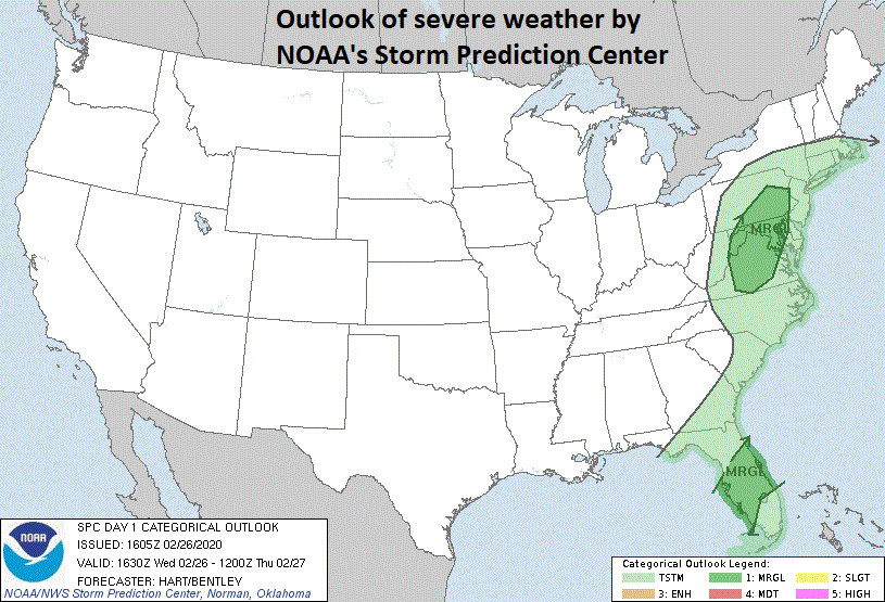
There is a “marginal” threat of severe weather in the Mid-Atlantic region according to the latest outlook by NOAA’s Storm Prediction Center (SPC) based in Norman, Oklahoma
Northwest winds will continue to be quite noticeable on Thursday night and Friday and then a reinforcing cold air mass will arrive in the region on Friday night. There can be some snow shower activity with the arrival of this next shot of cold air from Friday night into early Saturday. The colder-than-normal conditions will continue through Sunday, but there will be some sunshine on both weekend days and it should turn warmer again during the early part of next week.
Meteorologist Paul Dorian
Perspecta, Inc.
perspectaweather.com
Follow us on Facebook, Twitter, YouTube
Video discussion: