11:45 AM (Friday) | *Potential major rain event next week from the Lower Mississippi Valley to the eastern US*
Paul Dorian
A couple of waves of energy in the upper part of the atmosphere will play a role next week in a potential major rain event for much of the eastern half of the nation; map courtesy NOAA, tropicaltidbits.com
Overview
The weekend will turn out to be quite cold for this time of year in the Mid-Atlantic region and Northeast US, but a warming trend will begin on Sunday across the Mississippi Valley. At the same time, a strong wave of energy in the upper part of the atmosphere will crash into California and this will become one key player in the eastern half of the nation by the middle of next week. The combination of warmer and increasingly humid air and strong energy aloft may very well result in a major rain event next week from the Lower Mississippi Valley to the eastern US.
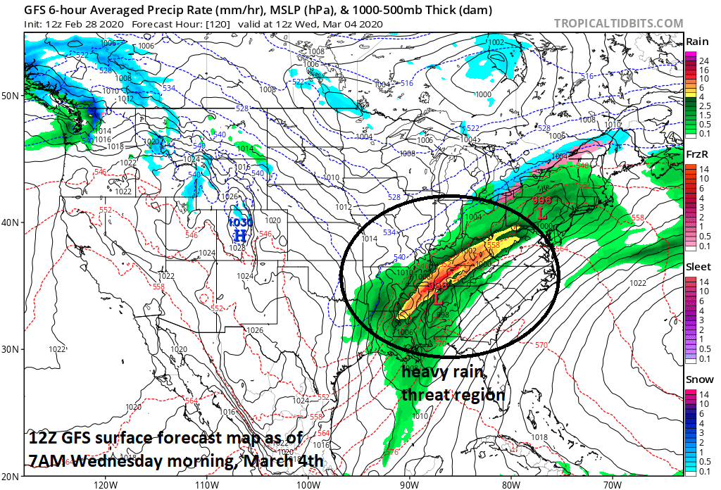
One key ingredient to a potential major rain event next week will be large-scale southwesterly flow of air that should develop in the Mississippi Valley. This broad flow of air will pump increasingly moist Gulf of Mexico air into much of the eastern half of the nation by the middle of next week.; map courtesy NOAA, tropicaltidbits.com
Details
By the latter part of the weekend, there will be a broad southwesterly flow of air extending from the south-central states to the Great Lakes. This large-scale flow of air will form on the back side of strong high pressure that will be located near the eastern seaboard by the end of the weekend. Not only will the southwesterly flow of air produce a significant warm up early next week in the Mississippi/Tennessee/Ohio Valleys, it’ll pump in increasingly moist-laden air from the Gulf of Mexico. This warmer and more humid air will become well established in this region before one vigorous wave of energy ejects eastward from California on Monday and a second “vorticity” maxima drops southeastward from south-central Canada.
12Z GFS forecast map of significant rainfall in the Mississippi, Tennessee and Ohio Valleys by early Wednesday. Flash flooding may become a serious concern in this region and severe weather is likely to become a threat as well.; map courtesy NOAA, tropicaltidbits.com
Once this upper level support pushes into the middle of the country from the western US, rain is likely to break out in the south-central states and the potential will grow for a major rain event from the Lower Mississippi Valley to across the Tennessee and Ohio Valleys and, ultimately, into the eastern US. Another wave of energy aloft will drop southeastward from south-central Canada across and flow along in the northern jet stream and this too will contribute to the possibility of a major rain event for much of the eastern half of the nation. The time frame for this potential heavy rain event in the Mississippi/Tennessee/Ohio Valleys is late Tuesday into Wednesday and several inches of rain is on the table. Many of these same areas have received some heavy rainfall during the past couple of weeks and this could enhance the chances for localized flash flooding.
12Z GFS forecasts a shift of the significant rainfall to the eastern US by later Wednesday and accumulating snow is a threat in the higher elevation locations of the interior Mid-Atlantic/Northeast US; map courtesy NOAA, tropicaltidbits.com
In the eastern states, it’ll turn noticeably warmer by Tuesday and Wednesday of next week with highs of 60+ degrees possible on both days in DC, Philly and NYC. A strong west-to-east moving cold front will then rush towards the eastern seaboard late Wednesday and this could lead to a round of heavy showers and possible strong thunderstorms on Wednesday and Wednesday night. It may be cold enough for accumulating snow late Wednesday/Wednesday night in the higher elevation interior locations of the Mid-Atlantic/Northeast US. A much colder air mass will follow behind the frontal system on Thursday which is liable to turn out to be another very windy and cold day in the Mid-Atlantic region and Northeast US. A strong “clipper” system may then drop southeast across the Great Lakes late next week with the threat of snow and/or rain in the Mid-Atlantic/Northeast US.
NOAA’s “7-day total precipitation amounts” forecast map is shown here with several inches of rainfall on the table for the Mississippi and Tennessee Valleys (courtesy NOAA/WPC).
Meteorologist Paul Dorian
Perspecta, Inc.
perspectaweather.com
Follow us on Facebook, Twitter, YouTube
Video discussion:


