1:30 PM (Thursday) | *Unseasonably warm weather on Friday ahead of a strong cold front…progressively colder this weekend…some snow is a threat in parts of the Mid-Atlantic by early next week*
Paul Dorian

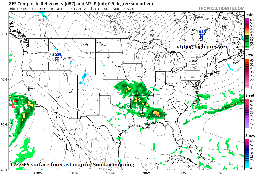
One key player in the threat for snow early next week will be the strong, cold high pressure system over southeastern Canada. It will be act as an anchor for the cold air mass in the Mid-Atlantic/NE US causing it to retreat only slowly to the northeast on Monday. Courtesy NOAA, tropicaltidbits.com
Overview
Tomorrow may turn out to be the warmest day so far this season in the Mid-Atlantic region with temperatures soaring to the 70’s in the DC-to-Philly-to-NYC corridor ahead of a strong cold frontal system. In addition, there will be occasional showers; especially, during the afternoon and evening hours and perhaps a strong-to-severe thunderstorm or two mixed in as well. Following the passage of the strong cold front late Friday night, the weekend will become progressively colder as strong high pressure builds into southeastern Canada. By the end of the weekend, moisture will be advancing northeastward towards the Mid-Atlantic region from the Tennessee Valley and our entrenched cold air mass will be reluctant to give up its ground. As a result, there is the chance for some snow or a mix of rain and snow in at least parts of the Mid-Atlantic region early next week and significant snowfall may fall across upstate New York and New England.

Low pressure will head towards the North Carolina coastline on Monday and there can be some snow (shown in blue) in parts of the Mid-Atlantic region. Courtesy NOAA, tropicaltidbits.com
Details
A warm front is pushing northward through the region today and its passage along with an advancing cold front will boost temperatures on Friday into the 70’s in the I-95 corridor. In fact, there is an outside chance that places like Washington, D.C. have a flirtation with the 80 degree mark on Friday afternoon. In addition to the warmth, the winds will pick up noticeably from a southwesterly direction and there are likely to be occasional showers in the afternoon and evening hours. Furthermore, with the expected instability on Friday afternoon and evening (warm, humid, strong cold front), there can be some strong-to-severe thunderstorm activity.

Colder-than-normal conditions will persist into early Monday in the Mid-Atlantic/NE US. Courtesy NOAA, tropicaltidbits.com
Following the strong cold frontal passage, the weekend will turn progressively colder in the Mid-Atlantic region with highs on Sunday afternoon confined to the 40’s as compared with the 70’s on Friday. By late Sunday, strong, cold high pressure will be situated over the southeastern part of Canada anchoring our cold air mass and it will be slow to retreat to the northeast on Sunday night and Monday. At the same time, moisture will be advancing this way from the Tennessee Valley and it may still be cold enough for some snow late Sunday night and early Monday in at least parts of the Mid-Atlantic region before a likely changeover to plain rain. As is the normally the case this time of year, the favored areas for snow will be the higher elevation locations to the north and west of Route I-95. Stay tuned.
Meteorologist Paul Dorian
Perspecta, Inc.
perspectaweather.com
Follow us on Facebook, Twitter, YouTube
Video discussion: