
1:00 PM | *Active early spring-time weather pattern to bring multiple storms across the country...cold air outbreaks to continue into early April for the central and eastern US*
Paul Dorian

Overview
Multiple storms will track across the country over the next several days bringing significant rainfall to much of the eastern half of the nation, substantial snowfall to higher elevation locations across interior New York State and New England, and severe weather to the Deep South, Tennessee and Ohio Valleys. This active weather pattern is partly the result of continuing cold air outbreaks into the central and eastern US which will very likely persist right into early April. The first storm of a series of upcoming storms is currently bringing heavy rainfall to portions of the Mid-Atlantic region and Northeast US and also accumulating snow to higher elevation interior sections of New York State and New England. A second storm will bring more significant rainfall to the Mid-Atlantic region later Tuesday night into Wednesday and there can be snow on the northern edges of this next storm system. By the end of the week and early weekend, low pressure will intensify over the nation’s midsection and a frontal boundary zone will extend from the low pressure center to the Mid-Atlantic region. The combination of the low and frontal system will produce more unsettled weather conditions on Friday, Saturday and Sunday in much of the eastern half of the nation.

Details
A storm is strengthening today along the Mid-Atlantic coastline and it’ll move northeastward over the next 24 hours to a position off the coast of Maine by early tomorrow. Soaking rain continues to fall at mid-day in parts of the Mid-Atlantic and coastal sections of the Northeast US and interior higher elevation locations of upstate New York and New England are getting hit by early springtime snows. The especially hard hit areas in terms of snow from this initial storm will be the higher elevations of the Catskills, Adirondacks, Berkshires, Green and White Mountains.

High pressure will build into the Mid-Atlantic and NE US on Tuesday, but the break in the action will be rather short-lived. Another storm will push eastward from the western US, across the SW US and into the central Plains by later tomorrow. As this storm pushes into the Plains on Tuesday, a large area of precipitation will break out as Gulf of Mexico moisture is drawn into the storm system. Rain will extend into the Tennessee and Ohio Valleys by late tomorrow and then breakout in the Mid-Atlantic region in the wee hours of the morning on Wednesday. Thunderstorms with this second storm will likely produce severe weather from the Plains eastward into the Mississippi and Tennessee Valleys over the next couple of days.

By the late week, yet another low pressure system will begin to intensify over the middle of the country and a frontal system is likely to extend far to its east to the Mid-Atlantic region. This nearly stationary frontal boundary zone will act as a focus for showers and thunderstorms potentially on the severe side from the Plains to the Ohio Valley. Showers will likely return to the Mid-Atlantic region on Friday and continue off and on into the weekend given the combination of a nearly stationary frontal system and low pressure system which will ultimately head northeastward towards the eastern Great Lakes. Similar to the early week storms, this third system could result in some snowfall for the interior higher elevation locations of the Northeast US.
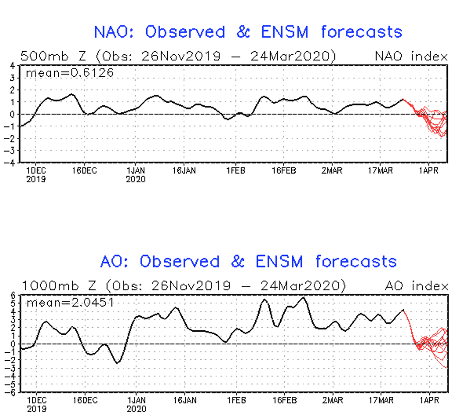
NAO (top) and AO (bottom) teleconnection indices will drop in value in coming days to “neutral” or even “negative” territory which generally is favorable for cold air outbreaks this time of year from Canada into the central and eastern US; maps courtesy NOAA
Looking ahead, teleconnection indices such as the North Atlantic Oscillation (NAO) and Arctic Oscillation (AO) continue to support the idea of a continuation of cold air outbreaks from Canada into the US over the next couple of weeks. In fact, there are signs of a widespread outbreak of colder-than-normal air to encompass much of the central and eastern US during the first week of April. These cold air outbreaks will support an on-going active weather pattern and will provide support for severe weather im many sections of the country (i.e., clashing air masses).
Meteorologist Paul Dorian
Perspecta, Inc.
perspectaweather.com
Follow us on Facebook, Twitter, YouTube