
2:10 PM (Wed) | *“Clipper” system and an inverted trough (aka “norlun” trough) to bring rain and/or snow showers to the Mid-Atlantic/NE US…possible small-scale heavier bands of precipitation*
Paul Dorian

An inverted trough (aka “norlun” trough) may extend northwest on Friday to the Mid-Atlantic region from a strong storm over the western Atlantic Ocean…occasionally this type of atmospheric setup results in small-scale heavier precipitation bands. Map courtesy NOAA, tropicaltidbits.com
Overview
A strong “clipper” system will drop southeastward across the Great Lakes on Friday and it’ll feature some quite cold air in the upper part of the atmosphere. At the same time, the southern storm that continues today to produce significant rainfall from Texas to the Carolinas will intensify after it moves into the western Atlantic. While this storm will be situated well off the east coast by later Friday, there can be an inverted trough of low pressure (aka “norlun” trough) extending from the low pressure center all the way back to the Mid-Atlantic region which can also contribute to some instability in the atmosphere. The combination of the “clipper” system and the inverted trough is likely to lead to rain and/or snow showers on Friday and Friday night and we’ll have to closely monitor the situation to see if any heavier bands of precipitation develop; especially, across places like eastern PA and NJ.

There will be two systems of interest on Friday/Friday night in the eastern half of the nation with a northern stream wave of energy (the “clipper) over the Great Lakes and a southern stream system over the Carolinas. The combination of the two systems may create rather unstable conditions in the Mid-Atlantic region and northeast US. Map courtesy NOAA, tropicaltidbits.com
Details
A significant rain event continues today across the southern states from Texas to the Carolinas and severe weather remains a threat in this part of the country. Low pressure in the southern branch of the jet stream will trek eastward along a stalled out frontal boundary zone over the next 24 hours and reach the Carolina coastline tomorrow night. By early Friday, the southern storm will be in a position over the western Atlantic and it will continue to intensify. By later Friday, an inverted trough will likely extend from the center of the low pressure system all the way back to the Mid-Atlantic region. This inverted trough is sometimes referred to as a “norlun” trough and it sometimes results in some heavier precipitation bands which will have to be monitored on Friday and Friday night; especially, in places like eastern Pennsylvania and New Jersey.
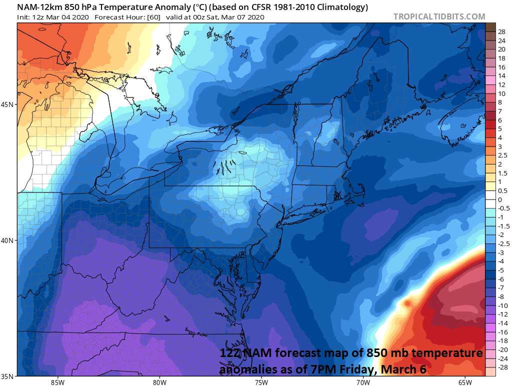
The “clipper” system on Friday/Friday night in the Mid-Atlantic/NE US will have rather cold air aloft and this can help to produce snow in areas of heavier precipitation bands - should they develop - even with surface temperatures above freezing; map courtesy NOAA, tropicaltidbits.com
At the same time, a ‘clipper” system will drop southeastward into the northeastern part of the nation and it’ll feature some cold air in the upper part of the atmosphere. In an unstable atmosphere with cold air aloft, heavier precipitation bands could produce snowfall even with surface temperatures above freezing as they are likely to be on Friday and Friday night. The combination of the “clipper” system and the potential inverted trough of low pressure over the western Atlantic will likely make for quite an unstable day as we close out the work week.
Following the late week setup, the weekend will start off on the chilly side, but a major warm up will take place early next week. In fact, the weather on Monday in the I-95 corridor region of the Mid-Atlantic could feature sunshine and warmth with temperatures well up in the 60’s for afternoon highs.
Meteorologist Paul Dorian
Perspecta, Inc.
perspectaweather.com
Follow us on Facebook, Twitter, YouTube
Video discussion: