
11:15 AM (Thurs) | **Rain and/or snow showers later Fri./Fri. night in the Mid-Atlantic due to “clipper” system and an ocean storm…small grassy accumulations possible tomorrow night in some spots**
Paul Dorian

An inverted trough will extend from a strong ocean storm late tomorrow to the Mid-Atlantic region and it can result in some small-scale heavier bands of precipitation; map courtesy NOAA, tropicaltidbits.com
Overview
A strong “clipper” system will drop southeastward into the Mid-Atlantic region on Friday and it’ll feature some rather cold air in the upper part of the atmosphere. At the same time, the southern storm that continues today to produce significant rainfall in the SE US will intensify after it moves out over the open waters of the western Atlantic. In fact, this storm could intensify to a point where it is produces hurricane-force winds by tomorrow night in the western Atlantic. While this ocean storm will be situated well off the east coast, it’ll still have an influence in the Mid-Atlantic region as an inverted trough (aka “norlun” trough) will extend from the low pressure center all the way back to the Mid-Atlantic. The combination of the “clipper” system in the northern stream and the inverted trough associated with the ocean storm is likely to lead to rain and/or snow showers in the Mid-Atlantic later tomorrow and tomorrow night. In some “norlun” trough cases, small-scale heavier precipitation bands can develop and we’ll have to closely monitor that possibility late tomorrow and tomorrow night.
Details
A significant rain event continues today across the SE US and severe weather remains a threat in southern Georgia and northern Florida. Low pressure in the southern branch of the jet stream will continue to trek to the east-northeast later today and tonight to a position off the Carolina coastline by early Friday. As the ocean storm pushes over the warmer waters of the Gulf Stream, it’ll intensify quite rapidly later tomorrow to the point where it can generate hurricane-force winds in the western Atlantic. In addition, there is likely to be an inverted trough late tomorrow that will extend from the center of the low pressure system all the way back to the Mid-Atlantic region. This inverted trough is sometimes referred to as a “norlun” trough and it sometimes results in small-scale heavier precipitation bands and this will be monitored closely later tomorrow and tomorrow night; especially, for places like eastern Pennsylvania, Delmarva Peninsula and New Jersey.

The southern storm that has been producing significant rain and severe weather this week from Texas to the Carolinas will move out over the warm waters of the western Atlantic on Friday. This storm will intensify rapidly later tomorrow to the point where it can produce hurricane-force winds. Meanwhile, a wave of energy over the Ohio Valley early tomorrow will dig into the Mid-Atlantic region. Map courtesy NOAA, tropicaltidbits.com
At the same time the ocean storm intensifies off the east coast on Friday, a ‘clipper” system will drop southeastward into the northeastern part of the nation. This system will feature some quite cold air in the upper part of the atmosphere which will get “absorbed” into the overall pattern by tomorrow night. As a result, the precipitation that falls initially on Friday afternoon in the Mid-Atlantic region is liable to be in the form of rain, but by tomorrow night there can be enough cooling aloft to allow for the formation of snow showers. The best chance for snow showers tomorrow night will be in the far northern suburbs of DC and in the northern and western suburbs of Philly and there can be small grassy accumulations in some spots. The best chance for small accumulations will be in the higher elevation suburbs along the DC-to-Philly corridor.
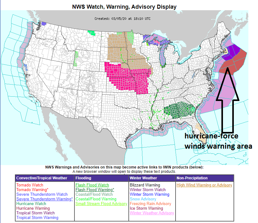
Powerful ocean storm on Friday and Friday night could generate hurricane-force winds in the western Atlantic after dramatic intensification; map courtesy NOAA
Following the late week mess, the weekend will start off on the chilly and dry side in the DC-to-Philly-to-NYC corridor, but a major warm up will take place early next week. In fact, the weather on Monday in DC, Philly and NYC should feature sunshine and warmth with temperatures well up in the 60’s for afternoon highs - a great time for a 3-day weekend.
Meteorologist Paul Dorian
Perspecta, Inc.
perspectaweather.com
Follow us on Facebook, Twitter, YouTube
Video discussion: