2:45 PM (Friday) | **Explosive intensification of an ocean storm about to take place…rain showers today…rain and/or snow showers tonight in the Mid-Atlantic**
Paul Dorian

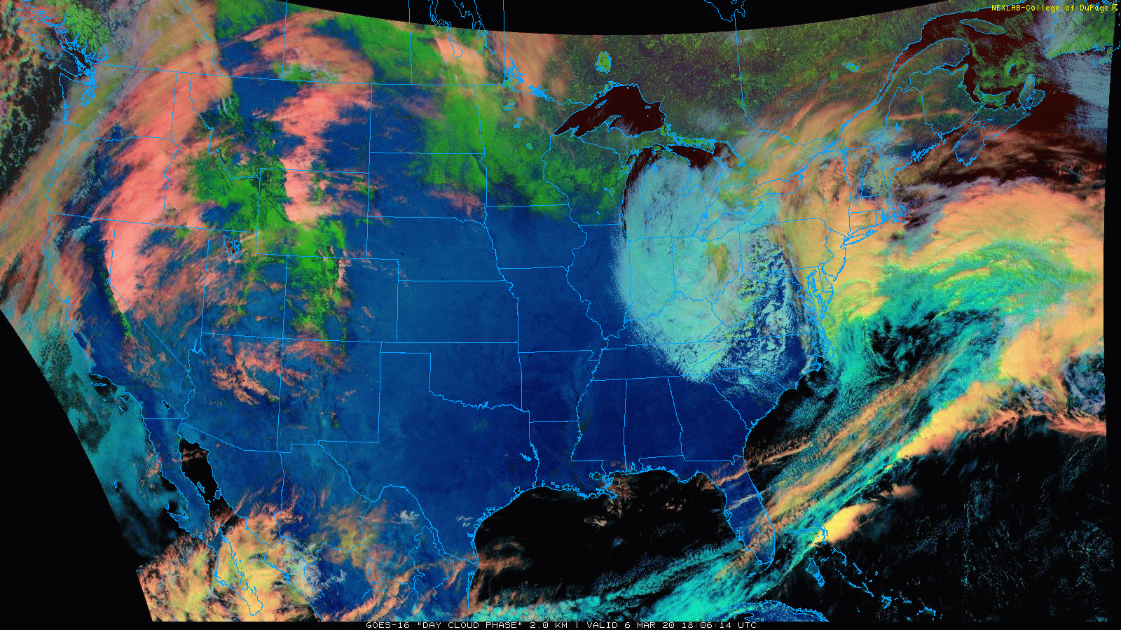
This particular channel of the GOES-16 satellite system rather nicely shows the “clipper” system over the Ohio Valley/western Mid-Atlantic with cold air aloft (bluish area) and the developing ocean storm over the western Atlantic (orange area); courtesy NOAA, College of DuPage, University of Wisconsin
Overview
Explosive intensification is about to take place with an ocean storm now over the western Atlantic. A strong “clipper” system is moving into the Mid-Atlantic region and it is interacting with the upper-level energy that remains from the ocean storm which soaked the southern US earlier in the week. This interaction will result in a drop of central pressure of the ocean storm from around 992 millibars (29.29 inches) at the current time to around 965 millibars (28.50 inches) by the middle of tonight. While this ocean storm is situated well off the east coast, it is still going to influence the Mid-Atlantic region late today and tonight as an inverted trough (aka “norlun” trough) is forming from the center of the low pressure system northwestward to the Mid-Atlantic. As a result, there are rain showers this afternoon throughout the Mid-Atlantic region and even a few embedded thunderstorms. However, as colder air aloft becomes wrapped up into the overall system, a mixing with and changeover to snow is possible later today or early tonight in many spots and there can even be some grassy accumulations; especially, in higher elevation suburban locations.

An inverted trough (i.e., convergence zone) is extending to the northwest of the low pressure system over the western Atlantic. The current central pressure of the low is around 992 millibars. Map courtesy NOAA, tropicaltidbits.com
Details
The latest GOES-16 satellite imagery loop using the “day cloud phase” RGB distribution channel clearly depicts two separate systems that are now phasing together. An upper-level “clipper” system with quite cold air aloft can be seen over the Ohio Valley (bluish tinge) and the developing ocean storm is seen over the western Atlantic (orange area). There has been snow associated with the “clipper” system today with higher elevation locations like Snowshoe Mountain in West Virginia getting hit pretty hard with 5-10 inches possible by tonight. The “clipper” system is quite unstable with plenty of very cold air in the upper-part of the atmosphere which can lead to some convection later today (i.e., thunderstorms) in parts of the Mid-Atlantic. Rain is currently dominating the scene closer to the east coast associated with the departing low pressure (i.e., southern storm) which is soon to undergo rapid intensification with tremendous diffluence aloft and convergence in the lower levels of the atmosphere.

The ocean storm will undergo rapid intensification over the next several hours with strong diffluence in the upper part of the atmosphere and low-level convergence. The forecasted (12Z NAM) central pressure by the middle of the night is around 965 millibars which is a drop of 27 millibars from the current time. Map courtesy NOAA, tropicaltidbits.com
An inverted trough is forming on the northwest side of the ocean storm with a narrow area of convergence along the axis extending from the center of the low to the Mid-Atlantic region. This trough will combine with the “clipper’s” upper-level energy and cold air aloft to keep it quite unsettled in the Mid-Atlantic region well into the nighttime hours. As colder air aloft gets wrapped into the system, the current rain could mix with or change to snow in many parts of the I-95 corridor region by later in the day or early tonight. There can even be some small grassy snow accumulations in the I-95 corridor region by later tonight and, as is often the case this time of year, elevation will play an important role in any potential snow accumulations with the greatest chance in the higher elevation suburban spots. The threat for snow tonight will extend from Pennsylvania and New Jersey all the way down to the northern and western suburbs of DC.
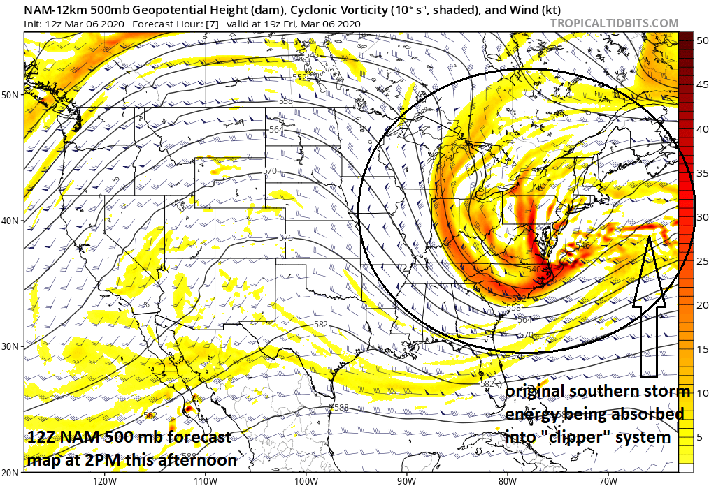
A large area of upper-level energy now sits over the northeastern quadrant of the nation and is contributing to the explosive development of an ocean storm. map courtesy NOAA, tropicaltidbits.com
Following this very interesting end to the work week, the weekend will start off on the cold, windy and dry side in the DC-to-Philly-to-NYC corridor, but a major warm up will take place early next week. In fact, the weather on Monday in DC, Philly and NYC should feature sunshine and warmth with temperatures well up in the 60’s for afternoon highs.
Two final notes: first, it is time to once again to turn the clocks forward as of 2 AM on Sunday. Second, for more information on the “norlun trough” if interested, please check out one of our Meteorology 101 videos (fourth one listed).
Meteorologist Paul Dorian
Perspecta, Inc.
perspectaweather.com
Follow us on Facebook, Twitter, YouTube
Video discussion: