12:00 PM (Monday) | *Recap of the “derecho” that blasted through Pennsylvania and New Jersey on Wednesday, June 3rd...a look back at June 2012*
Paul Dorian
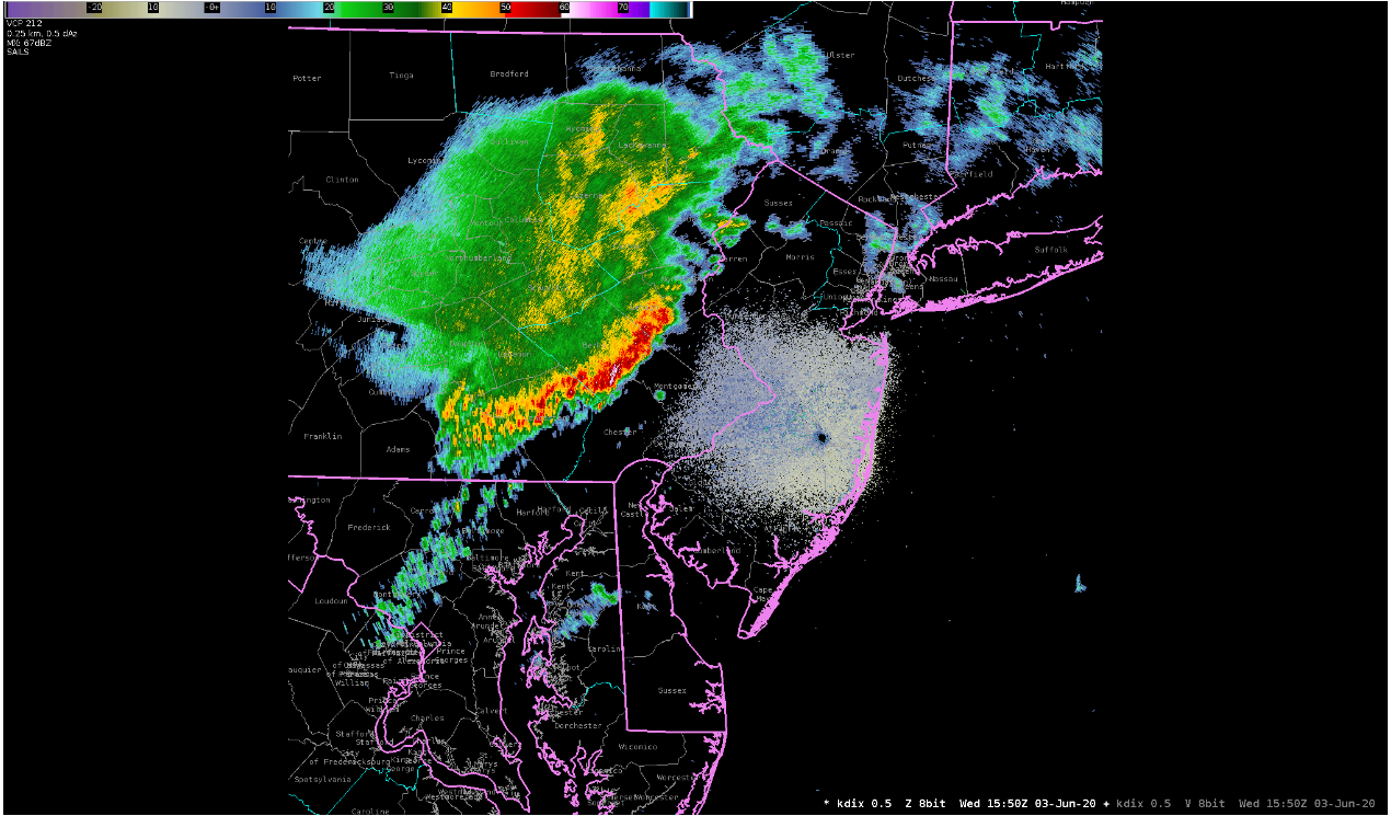
A line of powerful thunderstorms blasted through Pennsylvania on Wednesday, June 3rd, from the northwest part of the state to the southeastern corner and then the “derecho” pushed through central and southern New Jersey. Map courtesy NOAA/Philly NWS
Overview
A “derecho” is defined as a widespread, long-lived wind storm associated with bands of quickly moving showers and thunderstorms. Although a “derecho” can produce destruction similar to that of a tornado, the damage typically occurs in one direction along a relatively straight path. By definition, if the extent of wind damage is for more than 250 miles, includes wind gusts of at least 58 mph along its path, and also includes several, well-separated wind gusts of 75 mph or greater, then the event may be classified as a “derecho”. One such event took place last Wednesday, June 3rd, across much of Pennsylvania and New Jersey - and some are still feeling the impact.
Background
The word “derecho” was coined in 1888 by a professor of physics at the University of Iowa who used the term in a paper published by the American Meteorological Journal. Dr. Gustavus Hinrichs wanted to distinguish thunderstorm-induced straight-line winds from the rotary or circular winds of tornadoes in his paper of 1888. “Derecho” is a Spanish word meaning “direct” or “straight ahead” which contrasts it from the word “tornado” which is thought to have been derived from the Spanish word “tornar” which means “to turn”. Derechos in the United States are most common in the late spring and summer (May through August), with more than 75% occurring between April and August [Source: NOAA/SPC/Steve Corfidi].
The surface weather map early on Wednesday, June 3rd, featured strong high pressure over the Southeast US which provided summer-like warmth and humidity for the Mid-Atlantic region. Map courtesy NOAA/Philly NWS.
Details
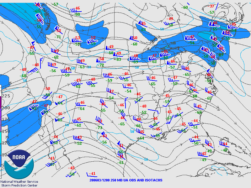
On Wednesday, June 3rd, the atmosphere was moist and unstable in much of the Mid-Atlantic region and a strong jet streak aloft was moving from the northern Ohio Valley into the northern Mid-Atlantic. A batch of thunderstorms developed early in the day in the lee of Lake Erie and were aided by a remnant mesoscale convective complex that originated in the Northern Plains on Tuesday. This vortex helped to provide “lift” in the atmosphere early Wednesday in the northern Mid-Atlantic which added “fuel to the fire” in the atmosphere.
A powerful jet streak in the upper part of the atmosphere played an important role in the excessive wind gusts that were measured at ground level during last Wednesday’s derecho event. Map courtesy NOAA/Philly NWS.
By late morning, the powerful jet streak aloft helped to generate extreme wind gusts at the surface level as a fast-moving line of thunderstorms blasted through Pennsylvania from its northwest-to-southeast corners. Several wind gusts of greater than 60 mph were reported from Berks County in Pennsylvania to Ocean County in New Jersey. A few examples of the excessive wind gusts include 83 mph at the Reading, PA Airport, 76 mph in Pottstown, PA, 61 mph was measured at Philly Intl Airport, and there were a couple of observations on the New Jersey coastline in excess of 90 mph. As a result, power outages became rather widespread along the path of the derecho. The storms moved quickly offshore by early afternoon, but lots of damage was already done, and the quick departure actually allowed the atmosphere to destabilize once again (i.e., low-level heating) and more storms intensified by late afternoon/early evening and moved into southeastern Pennsylvania affecting much of the same spots as those hit earlier in the day. In total, over 250 reports of wind damage were collected by the National Weather Service with hundreds of thousands left without power in southeast Pennsylvania and central/southern New Jersey – some for several days.
Looking back
Some of the most intense summer derechos, especially those of the progressive type, occur on the fringes of major heat waves. It turns out that the meteorological conditions favorable for large-scale heat waves often also are conducive to derechos. In the United States, this is especially true from the Upper Mississippi Valley and Upper Great Lakes into the Ohio Valley and Northeast. Examples include the July 1983 "I-94" derecho in the upper Mississippi Valley, the Mid-July 1995 derechos in New York and Canada, and the more recent Ohio Valley / Mid-Atlantic derecho of June 2012.
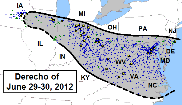
The derecho event that took place in late June 2012 was especially long-lived and destructive from the heartland to the east coast. Map courtesy NOAA/SPC.
While not the most intense or long-lived event ever observed, the June 29, 2012 Ohio Valley / Mid-Atlantic derecho was noteworthy in producing the all-time highest recorded June or July wind gusts at several official observing sites along its path (Fort Wayne, Indiana, Zanesville, Ohio, and Huntington, West Virginia), in addition to widespread, significant wind damage. Five million people lost power from Chicago to the mid-Atlantic Coast, and 22 people were killed. The storm also was notable for being arguably the first derecho to capture widespread media attention, striking as it did nearly every metropolitan area in a broadening path that extended from Chicago and Indianapolis to Baltimore, Washington, and Tidewater Virginia. [Source: NOAA/SPC/Steve Corfidi].
Meteorologist Paul Dorian
Perspecta, Inc.
perspectaweather.com
Follow us on Facebook, Twitter, YouTube


