
2:00 PM (Friday) | ****Severe thunderstorms and tropical downpours threat next 24-36 hours…spectacular air mass pushes in for Sunday/Monday…more tropical troubles****
Paul Dorian
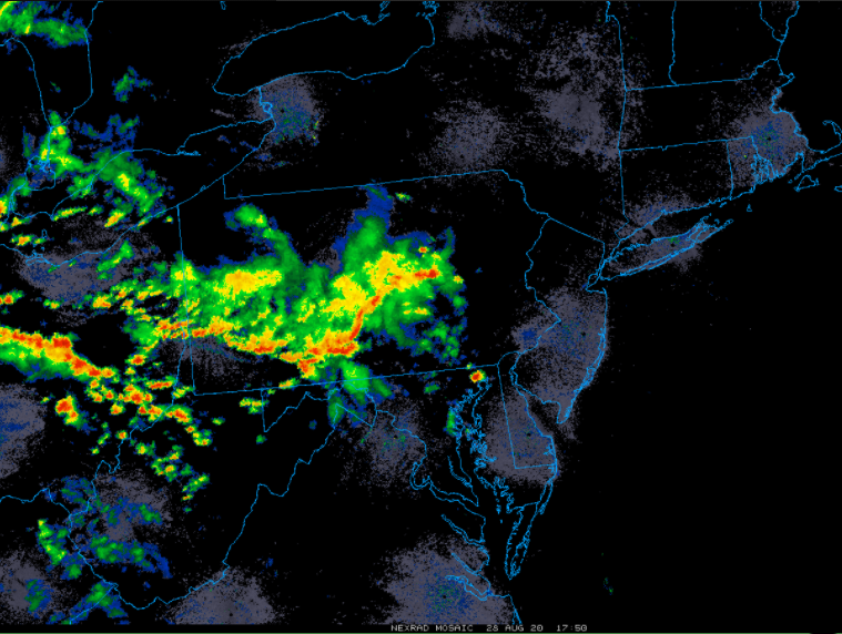
The Mid-Atlantic’s I-95 corridor are likely to get hit hard later today by the batch of showers and thunderstorms now across western and central Pennsylvania. Map courtesy University of Wisconsin/NOAA
Overview
The next 24-36 hours will be a very active period in the Mid-Atlantic region with the threat for severe thunderstorms from later this afternoon into tomorrow night and tropical downpours. There are even signs for a “bow echo” to form later today which could result in damaging wind gusts of > 60 mph (and possible power outages); especially, across eastern Pennsylvania and the southern and central parts of New Jersey. There is even the threat for isolated tornadoes later today in the I-95 corridor. Following all of this activity, a spectacular air mass for this time of year will ride in on stiff NW winds during the day Sunday and the very comfortable temperatures and humidity levels will stay around on Monday as well. Looking ahead, it’ll turn much more unsettled again around here on Tuesday and Wednesday with a renewed chance of showers and thunderstorms, and peaking even further down the road, there could be more tropical trouble to deal with in the eastern/southern states over the next week or two.

The threat exists later today for strong-to-severe thunderstorms in the I-95 corridor as depicted here by the 12Z NAM computer forecast model. Map courtesy NOAA, tropiocaltidbits.com
Severe thunderstorm threat…tropical downpours
It looks like another very active afternoon and evening for the Mid-Atlantic region as a stationary frontal system remains the focus area for showers and thunderstorms. In addition to the front, upper-level energy (vorticity max) is adding to atmospheric instability and any thunderstorm that pushes into the I-95 corridor later today and tonight can be strong-to-severe with heavy downpours, strong winds and possible hail. There are even signs for a “bow echo” to form later today which could result in damaging wind gusts (and power outages) across eastern Pennsylvania and the southern and central parts of New Jersey as well. There is even the threat for isolated tornadoes later today in the I-95 corridor. The most likely timetable for severe weather in the I-95 corridor is 3-9 PM. [A “bow echo” is the characteristic radar return from a mesoscale convective system that is shaped like an archer's bow. These systems can produce severe straight-line winds and occasionally tornadoes, causing major damage]. The vorticity max in the upper atmosphere moves through the region later tonight, but the chance of showers and thunderstorms in the Mid-Atlantic region will not end there.

One of the contributing factors later today for the chance of severe thunderstorm activity is an area of energy (i.e., vorticity) aloft that will be moving overhead. Map courtesy NOAA, tropicaltidbits.com
On Saturday, a strong upper-level trough with its associated cold frontal system will drop southeast from the Great Lakes region. At the same time, tropical moisture from the remains of Hurricane Laura will slide east from the Tennessee Valley into the Mid-Atlantic region. As a result, there can be additional showers and thunderstorms on Saturday and Saturday evening and some of the rain can be heavy at times and any thunderstorm can be strong-to-severe. In some spots, the rain can come down hard enough to produce localized flash flooding conditions; however, storm motions should be fast enough to limit this hazard.

A refreshing air mass arrives in the Mid-Atlantic/NE US on Sunday with much more comfortable temperatures and humidity levels. Map courtesy NOAA, tropicaltidbits.com
Much improved conditions will develop on Sunday as high pressure builds in from the northwest though winds will be gusty out of the NW. Temperatures and humidity levels will be much more comfortable on Sunday; especially, following the “tropical-moisture” levels likely to be experienced on Saturday. The nice weather will continue for most of the day on Monday although clouds may increase and then it’ll turn unsettled on Tuesday and Wednesday with a renewed chance of showers and thunderstorms.

“Laura” has been downgraded to a “tropical depression” and there are two new waves to monitor across the eastern Atlantic (marked by “X”). Map courtesy NOAA/NHC
More tropical troubles
“Laura” has been downgraded to a “tropical depression”, but its moisture will get wrapped-up into an incoming frontal system on Saturday and this could lead to some heavy rainfall in the Mid-Atlantic. There are now two new waves in the eastern Atlantic which will be closely monitored in coming days. The first system is likely to take a track towards the Caribbean Sea while the second is likely to take a slightly more northern route.
The overall weather pattern is about to undergo a transition from the recent upper-level trough situation over the Northeast US to upper-level ridging. In recent days, there has been strong high pressure ridging aloft centered over the southwestern Atlantic and this has resulted in the movement of tropical systems into the Gulf of Mexico. As ridging builds farther to the north and east, the door could open along the southeast coast of the US for a tropical hit…stay tuned.
Meteorologist Paul Dorian
Perspecta, Inc.
perspectaweather.com
Follow us on Facebook, Twitter, YouTube
Video discussion: