
11:45 AM | **Wintry mess of snow, ice, and rain coming to the Mid-Atlantic with small accumulations…late week storm headed to the Carolinas with little impact likely in DC, Philly, NYC**
Paul Dorian
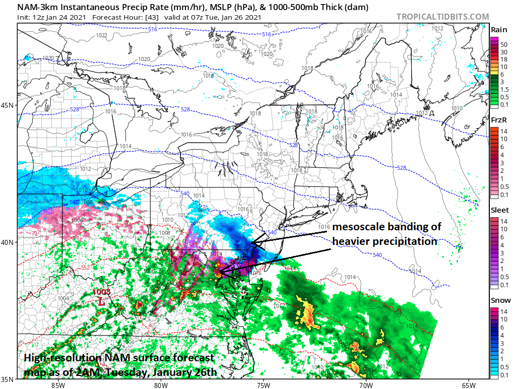
Mesoscale banding is a threat during the early week event which could produce bursts of heavier precipitation in localized areas (forecast map from 12Z NAM (3-km resolution)). Map courtesy NOAA, tropicaltidbits.com
Overview
A wintry mess of snow, sleet, freezing rain, and rain is coming to the Mid-Atlantic region early this week as low pressure heads from the central states to the Ohio Valley. A cold, dry air mass will still be in place on Monday morning when moisture begins to head in this direction from the west-to-southwest. This dense air mass will be reluctant to give up its ground; consequently, the northeastward progression of the precipitation along the I-95 corridor will be rather slow and some frozen precipitation is a good bet. In addition, the moisture field will tend to break apart some by the time it reaches areas to the north of the PA/MD border. Arrival time in the DC metro region is likely mid-to-late afternoon on Monday, late evening in Philly, but not until early Tuesday in NYC. A late week storm is likely to head towards the Carolina coastline with little impact likely in the DC-to-Philly-to-NYC corridor.

Upper-level support for the early week system and late week threat are featured on this 500 mb forecast map by the 12Z NAM for Monday morning. Map courtesy NOAA, tropicalttidbits.com
Details
The new work week will begin with high pressure across the Northeast US and cold, dry dense air in place along the DC-to-Philly-to-NYC corridor. At the same time, low pressure will begin to pull out of the central Plains and make a move towards the Ohio Valley and it will be accompanied by plenty of moisture. This moisture shield, however, will tend to fall apart some by later tomorrow night and Tuesday as it slowly pushes into areas north of the PA/MD border. The low pressure system in the Ohio Valley will tend to weaken by later tomorrow night and Tuesday as its upper-level support becomes more stretched out.

Freezing rain will be an issue of concern during this early week event as cold, dense air will be reluctant to give up its ground as moisture arrives from the west-to-southwest. Map courtesy NOAA, Weather Bell Analytics
A wintry mix of snow, sleet and rain is likely to arrive in the DC metro region during the mid or late afternoon hours, but the progression of the moisture to the northeast will be on the slow side. As a result, snow and/or sleet is not likely to arrive in the Philly metro region until late tomorrow night and it’ll likely hold off for New York City until early Tuesday morning. While snow accumulations will be limited in the DC-to-Philly-to-NYC corridor due to prospects for mixing and the weakening of the low pressure system, there can be some slick spots during this event; especially, on untreated surfaces. Temperatures will remain at or below freezing for much of the time during this event and the ground is quite cold following a weekend with modified Arctic air in place. The precipitation (light freezing rain, light snow) will tend to linger into late Tuesday night and early Wednesday morning across PA, NJ and NY as the low pressure system slides quite slowly across the region.
One additional note, there is the chance for mesoscale banding during this early week event which could result in bursts of heavier precipitation and localized higher amounts of snowfall. My general thinking on accumulations for the entire DC-to-Philly-to-NYC corridor is anywhere from a coating to a couple of inches by late Tuesday night with localized higher amounts possible due to the potential small-scale banding. The timetable of precipitation is as follows for some of the I-95 corridor metro regions:
DC:
Mid-late afternoon Monday through Tuesday morning…the Monday evening commute can be impacted
Philly:
Late Monday night through Tuesday night
NYC:
Early Tuesday morning to early Wednesday morning
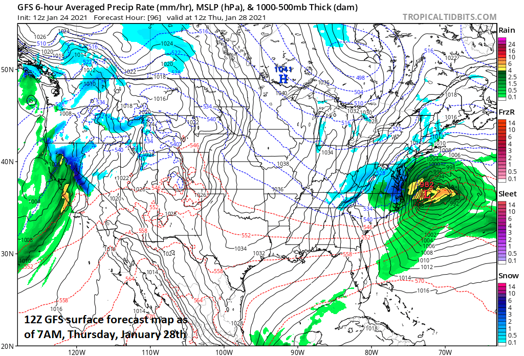
Late week storm threat continues for the Carolinas with likely little impact in Mid-Atlantic region. Map courtesy NOAA, tropicaltibits.com
Late week storm
After a quiet day on Wednesday, another low pressure system will take place over the central states and heads towards the Carolinas. This system will feature strong upper-level support and it could strengthen markedly near the Carolina coastline on Thursday. As a result, snow is likely to break out later Wednesday night across southern West Virginia and southern Virginia, and there could be some snow in the DC metro region by early Thursday. However, it appears that the precipitation shield from this late week storm will largely stay to the south and east of the I-95 region from DC-to-Philly-to-NYC with its likely greatest impact from southeastern Virginia to the Carolinas.

Incredible snowfall amounts are depicted over the next ten days in the Sierra Nevada Mountains of eastern California with nearly 14 feet predicted by the 12Z GFS in one particular location (indicated by arrow). Map courtesy NOAA, tropicaltidbits.com
One final note of interest, this early week storm had its origins in California as will the late week storm system. In fact, the next several days will feature additional storms for California with lots of rainfall in coastal sections and some incredible snowfall amounts across the Sierra Nevada Mountains of eastern California. One computer forecast model puts out as much as 14 feet of snow in the Sierra Mountains over the next ten days.
Meteorologist Paul Dorian
Perspecta, Inc.
perspectaweather.com