12:30 PM (Tues) | *Temperatures still hovering near freezing in many areas…watch for slick spots on untreated surfaces as wintry mess continues…late week cold blast...late weekend snow threat*
Paul Dorian

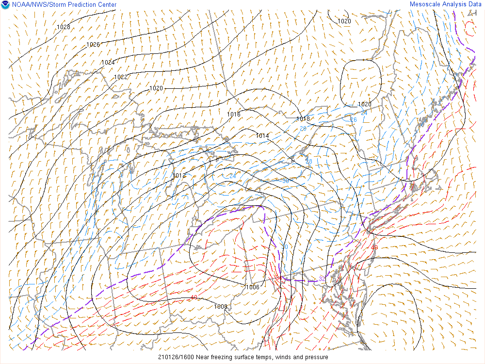
“Dashed purple line” represents the freezing line at the surface as of mid-day Tuesday. Icing can occur in suburban locations this afternoon on untreated surfaces as temperatures will be reluctant to rise above the freezing mark in many spots. Map courtesy NOAA
Overview
A wintry mess of snow, sleet, freezing rain, and/or plain rain continues in parts of the Mid-Atlantic region at mid-day and temperatures remain near the freezing mark in many locations. As a result, there can be slick spots this afternoon and evening on untreated surfaces in suburban locations along the I-95 corridor even as the precipitation winds down. After a drier and quieter day on Wednesday, low pressure will intensify off the Carolina coastline on Thursday and winds in the DC-to-Philly-to-NYC corridor will pick up noticeably as a very cold air mass pushes in from the northwest. The end of the week and the beginning of the weekend will indeed feature some of the coldest air yet this season and then attention will turn to the next storm threat which could bring snow by late in the weekend or the early part of next week.
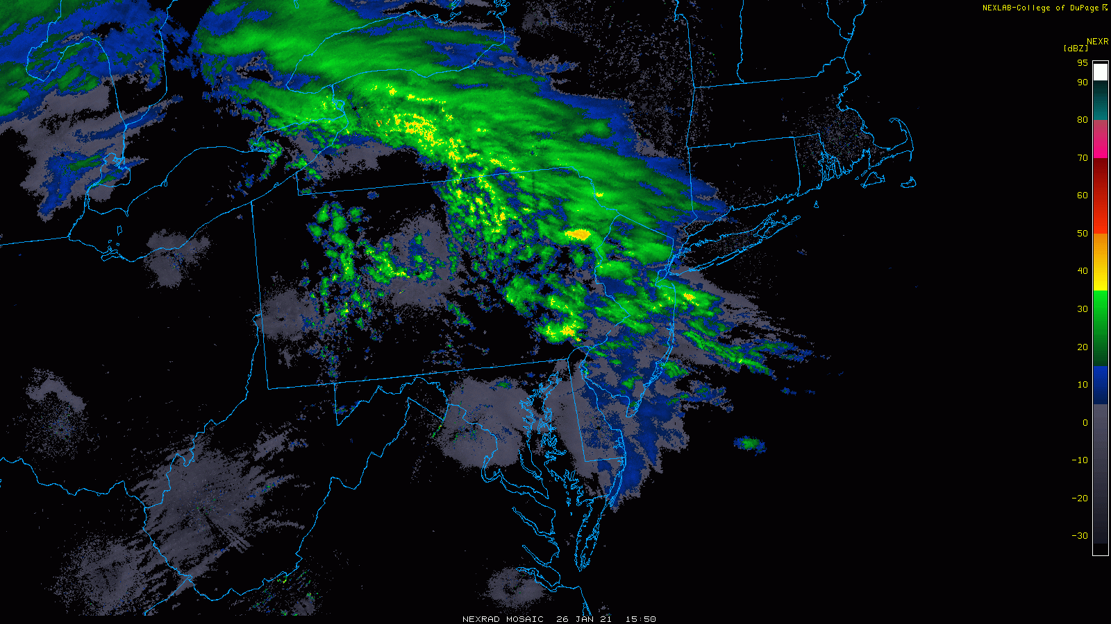
While the heavier precipitation is pushing off to the northeast at mid-day, there will be some lingering light freezing rain and drizzle in the Mid-Atlantic region into tonight. Images courtesy College of DuPage, NOAA
Details
Temperatures continue to hover near the freezing mark at mid-day from the far northern and western suburbs of DC (e.g., Gaithersburg at 33 degrees, Dulles Airport at 33 degrees) to the northern and western suburbs of Philly and NYC. Precipitation is beginning to wind down from southwest-to-northeast across parts of the Mid-Atlantic, but there will be a tendency for light freezing rain or drizzle to continue through the afternoon and into the evening. As a result, icing on untreated surfaces can occur through the afternoon and into the evening in many suburban locations along the I-95 corridor. On Wednesday, the moisture shield associated with this current system will push away to the northeast of here and drier air will return as high pressure pushes into the Mid-Atlantic.

The work week will end with a very cold air mass in place across the Mid-Atlantic region and Northeast US. It will stay well below-normal on Saturday as well as we begin the upcoming weekend. Map courtesy NOAA, tropicaltidbits.com
By Thursday, low pressure will begin to intensify along the Carolina coastline and the tightening pressure gradient between the departing high pressure system and the intensifying storm will produce increasingly strong NW winds in the DC-to-Philly-to-NYC corridor. As the storm pulls out into the western Atlantic, it will help to pull in some very cold air into the Mid-Atlantic for the end of the work week and the beginning of the upcoming weekend. In fact, temperatures are likely to bottom out in the teens for lows in many suburban locations on Friday morning and Saturday morning and they’ll struggle to pass the freezing mark on both days.

Another powerful storm will impact California in coming days and its upper-level support will be situated over northern region of Baja California by Friday night. This is the system that will cross the country this weekend and it could produce snow in the Mid-Atlantic region by Sunday and/or Monday. In fact, this particular computer forecast model run of the Euro goes all out with a massive snowstorm for the DC metro region…stay tuned on that. Map courtesy WSI, Inc., ECMWF
Looking ahead, another strong storm system will impact California in coming days with heavy coastal rains and significant inland snows and this system will cross the country this weekend. By the time we get to the latter part of the weekend, the moisture shield with this new system may begin to push into the Mid-Atlantic region and there will certainly still be some cold air in place following the late week cold air outbreak. An initial wave of low pressure will likely head towards the Ohio Valley by the latter part of the weekend and then a secondary storm could form just off or over the Mid-Atlantic coastline by early next week. As a result, there is the chance for snow or perhaps a “snow-changing-to-rain” scenario in the Mid-Atlantic region in the Sunday/Monday time frame – several days left to work out the details on this next threat.
Meteorologist Paul Dorian
Perspecta, Inc.
perspectaweather.com
Follow us on Facebook, Twitter, YouTube
Video discussion: