
10:15 AM (Friday) | ****Howling Arctic winds today in the Mid-Atlantic region…long duration winter storm event early next week****
Paul Dorian

A blocking pattern in the upper atmosphere will help to create a long duration winter storm event early next week in the Mid-Atlantic/NE US. Map courtesy Canadian Meteorological Centre, tropicaltidbits.com
Overview
Arctic air has its grip on the Mid-Atlantic region and it won’t loosen its control anytime soon. Winds will howl today out of the NW and the Arctic cold will stick around through the weekend. A long duration winter storm event will get underway on Sunday and, as a storm intensifies off the Mid-Atlantic coastline, impact can continue all the way into early Tuesday with significant snow accumulations of at least several inches on the table.

12Z NAM surface forecast map for 4PM Sunday, January 31st depicts “overrunning” type snow (in blue) during “phase 1” of the upcoming long duration winter storm event in the Mid-Atlantic/NE US. Map courtesy NOAA, tropicaltidbits.com
Details
This looks like a long duration winter storm event coming to the Mid-Atlantic region in the Sunday-Tuesday time period and it can be best described as two different phases.
“Phase 1” will be an initial outburst of “overrunning” type snow on Sunday and Sunday night as warmer air from the southwest rides up and over the dense, cold Arctic air mass that will be in place all weekend long. This Arctic air mass will be anchored by strong high pressure located to the north of New York State. The primary low pressure system that will produce this “overrunning” type of precipitation will move from the Central Plains on Saturday to the Ohio Valley by Sunday. This will likely be this low pressure system’s most northward extent – and also the beginning of its demise as its upper-level support will then transfer to the east coast.
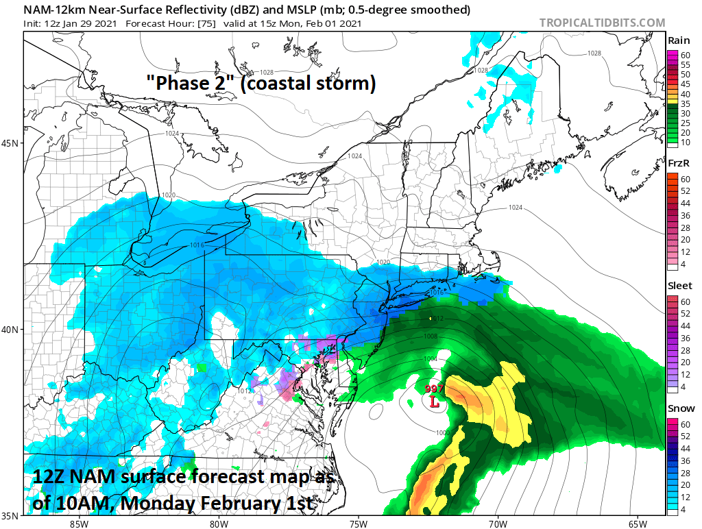
12Z NAM surface forecast map for 10AM Monday, February 1st depicts “coastal storm” generated snow (in blue) during “phase 2” of the upcoming long duration winter storm event in the Mid-Atlantic/NE US. Map courtesy NOAA, tropicaltidbits.com
“Phase 2” will take place from Monday into early Tuesday as a storm system intensifies near or just off the Mid-Atlantic coastline and this system will become the dominant player. Upper-level energy will swing around the base of a larger-scale trough and produce the upward motion near the Carolina coastline that should help to spawn this coastal storm. There is also a natural temperature gradient in this particular area between the relatively warm waters of the western Atlantic Ocean and the cold air mass that will be situated over the nearby land mass and this will contribute to storm formation near the Carolina coastline.
The strength of this coastal storm and its exact storm track will dictate how much snow will fall in the DC-to-Philly-to-NYC corridor and whether mixing can become an important factor and last for an extended period of time. A key point here is that the coastal storm will tend to stall out somewhere off the Mid-Atlantic coastline as it encounters a strong blocking pattern in the upper atmosphere over eastern Canada. Once this low stalls out over the western Atlantic, counterclockwise winds around it will likely pull down some colder air from the north and those areas that do change from snow to a mixture or rain in the I-95 corridor could change back to all snow on Monday and it is this “wrap around” snow that could extend this long duration event all the way into early Tuesday.

12Z NAM surface forecast map for 7PM Monday, February 1st depicts “wrap around” snow (in blue) during “phase 2” of the upcoming long duration winter storm event in the Mid-Atlantic/NE US. Map courtesy NOAA, tropicaltidbits.com
Significant accumulating snow of at least several inches is on the table for this upcoming long duration event in the Mid-Atlantic region from Sunday into Tuesday and this includes all the way to coastal sections of New Jersey and the Delmarva Peninsula. It is possible that the DC metro region gets some of its “best” snows (perhaps 3-5 inches) during “phase 1” from Sunday into early Sunday night while Philly and certainly the NYC metro region may get their “best” snows during “phase 2” when the coastal storm is the main player. The snow arrives in DC on Sunday morning and - similar to the wintry mix event earlier in the week - the precipitation may find it somewhat difficult for awhile in advancing to the northeast (i.e., towards Philly and NYC) as it battles a dense, dry, cold entrenched Arctic air mass.
As discussed earlier, two unknowns for this storm at this time involve the ultimate strength of the coastal storm and also exactly where will it stall out. Another unknown at this time is how much mixing will take place in the I-95 corridor and the length of this would have an impact accumulation amounts. It seems a good bet that the initial burst of snow on Sunday in the DC metro region will be followed by a period of mixed precipitation by late Sunday afternoon or early Sunday night. There is also a chance of mixing in the immediate Philly and NYC metro regions late Sunday night/early Monday and less chance of mixing in the northern and western suburbs…typical of most winter storms in the Mid-Atlantic region.
Stay tuned as more clarity is likely to come over the next couple of days regarding these unknowns in the upcoming long duration winter storm event.
Meteorologist Paul Dorian
Perspecta, Inc.
perspectaweather.com
Follow us on Facebook, Twitter, YouTube