
12:15 PM | *Nor’easter to pound much of the Mid-Atlantic/NE US with heavy rain/strong winds from later tonight into early Wed.…strong-to-severe storm threat to precede late today/early tonight*
Paul Dorian

A strong nor’easter is likely to form later tonight and Tuesday and it may loop around extending its impact all the way into Wednesday morning. Maps courtesy NOAA, tropicaltidbits.com
Overview
A powerful storm system has pounded the west coast during the past 24 hours or so and a strong Nor’easter is about to unfold just off the east coast. This developing Nor’easter will impact much of the Mid-Atlantic/Northeast US from later tonight into Wednesday morning with flash flooding type rains in some areas and potentially damaging wind gusts; especially, along coastal sections. The development of the east coast storm will wait for the arrival of a surface cold frontal system which will push eastward this afternoon from the Ohio Valley into the Mid-Atlantic. This frontal system can result in some strong-to-severe thunderstorm activity along the I-95 corridor from later today into early tonight following a day of near record warmth.

Severe thunderstorm activity is a threat late today and early tonight as a cold front arrives along the I-95 corridor. The best chance for severe weather will to the south of the PA/MD border. Map courtesy NOAA
Details
The US west coast from Washington-to-California has been pounded by a powerful storm system during the past 24 hours or so and the heaviest rainfall today in the Golden State is pushing southward through central California. Some specific observations out west include more than 5 inches of rain from this storm in San Francisco and in the state’s capitol there was quite an interesting result. Sacramento had their longest dry streak ever recorded end at 212 days with this storm which then produced their wettest 24-hour period ever of 5.44 inches (besting the prior record of 5.28” set all the way back in April, 1880). And now attention turns to the east coast of the US.

Hurricane force wind gusts are on the table from this unfolding Nor’easter along coastal sections of New Jersey, Long Island and southern New England with the most probable time for this being Tuesday night and Wednesday morning. Map courtesy NOAA, weather Bell Analytics
Low pressure and its associated cold frontal system is pushing eastward today from the Ohio Valley towards the Mid-Atlantic/Northeast US. This cold front will likely result in some strong-to-severe thunderstorm activity along the I-95 corridor from later today into early tonight. The best chance for severe weather as this front arrives is likely to be to the south of the PA/MD border, but the threat does exist across PA and New Jersey as well. By later tonight, the advancing surface front will combine with strong support aloft to set off the development of a storm off the Mid-Atlantic coastline. This off-shore storm will intensify later tonight and on Tuesday and then likely take a loop around from tomorrow night into Wednesday. As a result, this can turn into a rather long-lasting event with rain and wind; especially, along coastal sections from New Jersey to southern New England. The best chance for flash flooding type of rainfall will take place later tonight into Tuesday in the region extending from eastern PA to New Jersey/NYC and northward into southern New England. Wind gusts along coastal New Jersey, Long Island and southern New England can reach hurricane force during this nor’easter with the most likely timing for this threat from Tuesday night into Wednesday morning.
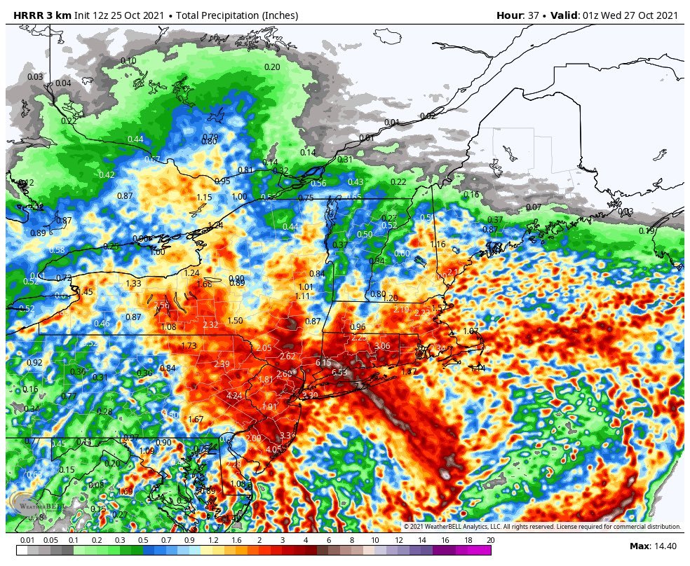
Significant rainfall is on the table from this unfolding Nor’easter with 2-4 inches possible in the region extending from eastern PA to New Jersey and northward through New York City to southern New England. Map courtesy NOAA, weather Bell Analytics
Looking ahead, another east coast storm is possible at week’s end as energy from today’s west coast storm slides to the eastern seaboard. Beyond that, a pattern change may result in winter-like cold next week – the first week of November – across the Midwest/Great Lakes/Mid-Atlantic and NE US in what could be a quick start to the winter season.
Meteorologist Paul Dorian
King of Prussia, PA
Video discussion: