11:20 AM | **Colder pattern begins this weekend in the Mid-Atlantic region…reinforcing shot of cold air early next week can come with the first snowflakes of the season**
Paul Dorian
A colder pattern begins this weekend in much of the eastern US following the passage of a strong cold front on Friday. Map courtesy NOAA, tropicaltidbits.com
Overview
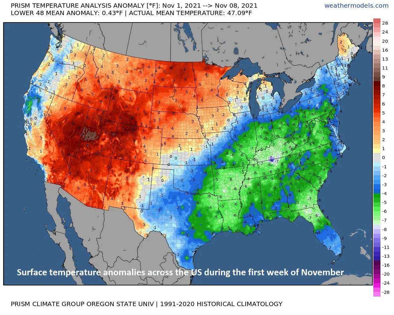
The first week of November averaged out to be quite a bit colder-than-normal in much of the eastern half of the nation, but the last couple of days have been quite pleasant for this time of the year and warmer-than-normal. It’ll remain warmer-than-normal in the Mid-Atlantic region into the day on Friday, but the passage of a strong cold front as the work week ends will usher in colder air for the upcoming weekend and it’ll set off an overall pattern change to colder-than-normal for much of the second half of the month. In fact, a reinforcing shot of cold air will arrive early next week and it could actually be accompanied by the first snow of the season in parts of the Mid-Atlantic region during Sunday night and Monday.
The first week of November averaged colder-than-normal across much of the eastern US. Map courtesy Prism Climate Group, Oregon State University, weathermodels.com
Details
Temperatures today have already climbed into the 60’s up and down the DC-to-Philly-to-NYC corridor and they are likely to do so again tomorrow afternoon and on Friday. A strong cold front will cross the region on Friday and there will be showers ahead of it on Thursday night and Friday morning. There can even be a thunderstorm or two mixed in with the passage of the cold front and some of the rain can come down hard for brief spells. The breeze will pick up on Friday afternoon as cooler, drier air arrives and then another cold front can cause a few showers on Saturday. Temperatures will be on a downward trend as we head through the weekend with afternoon highs in the 60’s on Friday replaced by the 50’s on Saturday afternoon and perhaps the upper 40’s on Sunday.
A reinforcing shot of cold air will arrive early next week in the Mid-Atlantic region and it can be accompanied by the first snow of the season on Sunday night and Monday. Map courtesy NOAA, tropicaltidbits.com
Another cold front will approach the region on Sunday night and Monday and this frontal boundary zone may feature a “clipper-type” of low pressure system that drops from northwest-to-southeast into the Midwest and then ultimately intensifies off the Mid-Atlantic coastline. This “clipper-type” of system could actually bring the first snow of the season to parts of the Mid-Atlantic region on Sunday night and Monday and a reinforcing chilly air mass will follow for the first half of next week. Snow accumulations are even on the table from this system in higher elevation interior locations of the Mid-Atlantic region well to the north and west of I-95. There will likely be a noticeable warm up during the second half of next week, but colder air is sure to follow by the time we get to the following weekend which will bring us right to the week of Thanksgiving.
Meteorologist Paul Dorian
Valley Forge, PA
Video discussion:


