
12:45 PM | *Additional cold air outbreaks as we head through the rest of November…a system to monitor in coming days for a snow threat early next week… MJO signal for more cold in December*
Paul Dorian
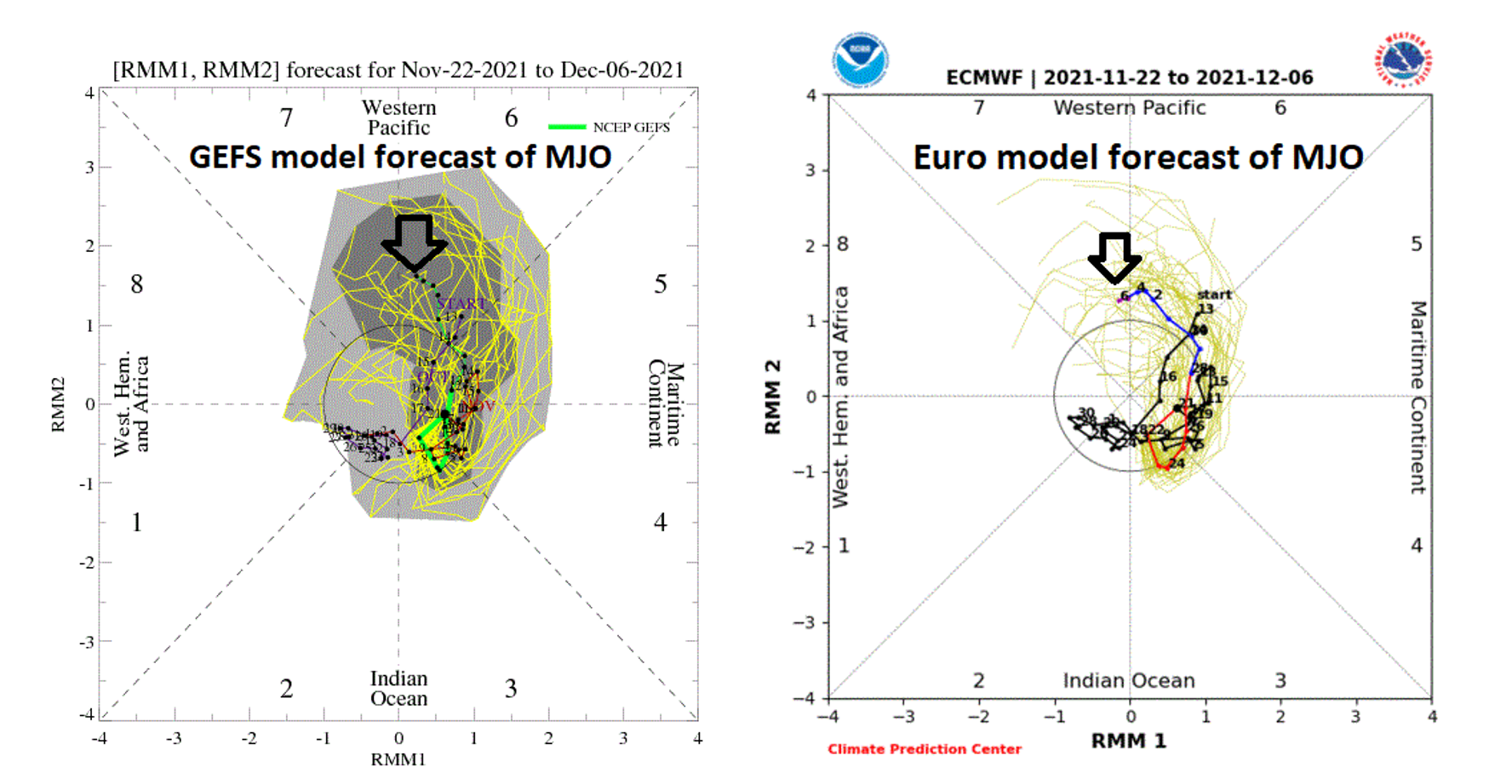
The GEFS (left) and Euro depict a relatively strong MJO in early December as it pushes toward phase 7. Plots courtesy NOAA, ECMWF
Overview
One cold air outbreak reached the Mid-Atlantic region late last week and another one is arriving today on increasing NW winds and a third one will arrive at the end of the week. In fact, it is possible that the only day of the next several that is at or slightly above-normal in terms of temperatures could be Thursday, Thanksgiving Day. While the overall pattern does favor additional cold air outbreaks for the Mid-Atlantic region in coming days, the chances for snow are more elusive. There is one system, however, that could become a player in about a week’s time and it will have to be monitored over the next few days for possible snow in the Sunday/Monday time frame. Looking ahead, one index known as the Madden Julian Oscillation (MJO) signals that cold air outbreaks may continue into the first half of December for the eastern half of the nation.

The US has experienced warmer-than-normal conditions in much of the wester half of the country during the first 20 days of November and at or below-normal conditions in much of the eastern US. Map courtesy NOAA, Prism Climate Group OSU, weather models.com
Outlook for the rest of November
A cold front has pushed off the east coast this morning and another colder-than-normal air mass will ride into the Mid-Atlantic region this afternoon on increasing NW winds and clearing skies from west-to-east. Temperatures have likely reached their highs for the day and will drop into the 20’s late tonight – some of the lowest readings so far in some areas. It stays cold and windy on Tuesday and still on the cold side of normal on Wednesday, but with much less wind it’ll feel less harsh. The one day of the next several that could actually turn out at or slightly above-normal is Thursday, Thanksgiving Day as sunshine should help to boost temperatures back up into the 50’s. That holiday warm up will be short-lived, however, as another cold front comes through by Friday and the end of the week will again be windy and colder-than-normal.

The 12Z GFS depicts an upper-level low to be near the east coast in about a week’s time…a system to be monitored in coming days. Map courtesy NOAA
In terms of precipitation for the Mid-Atlantic region, there can be an isolated snow shower or two over the next 36 hours or so south and east of the Appalachian Mountains and then Wednesday and Thursday should be dry…good days for travelers. Rain showers are possible later Thursday night into early Friday associated with the arrival of the late week strong cold frontal system.
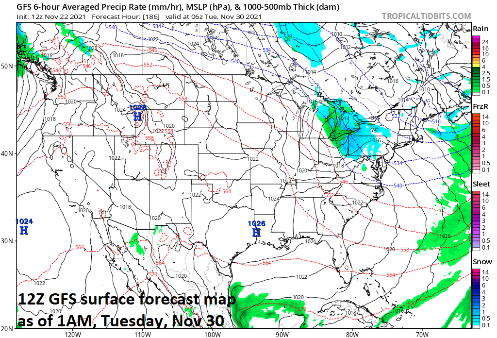
The 12Z GFS depicts some snow in the Mid-Atlantic region in about a week’s time…a system to be monitored in coming days. Map courtesy NOAA
Looking ahead, a reinforcing shot of cold air is likely to drop to the south and east from Canada during the early part of next week. There will also be an impressive disturbance in the upper part of the atmosphere that is likely to drop out of Canada and into the eastern part of the nation. This kind of system can result in a storm system near the Mid-Atlantic coastline in about a week’s time or so and, if all pieces fall into place, perhaps even be able to produce some snowfall for the region in the Sunday/Monday time frame…a threat to monitor in coming days.

A couple forecast models suggest the MJO will increase in strength as we get into early December and it will push into phase 7 and perhaps phase 8 - both of which are typically correlated with colder-than-normal conditions in the eastern half of the nation. Temperature composite plots courtesy NOAA
Madden Julian Oscillation (MJO) and a potential cold signal for December
There are clear signs for additional cold air outbreaks in the central and eastern US as we progress through the rest of November and to get a clue about the month of December it is worth taking a look at an index value known as the Madden Julian Oscillation or MJO. The MJO can be characterized as an eastward moving “wave” or “pulse” of clouds and enhanced tropical rainfall near the equator that typically recurs every 30-to-60 days. The anomalous rainfall is often first evident over the Indian Ocean, and remains apparent as it propagates eastward over the very warm waters of the western and central tropical Pacific. Over the cooler ocean waters of the eastern Pacific, the pattern of tropical rainfall generally becomes nondescript, but often reappears over the tropical Atlantic and Africa. One method meteorologists use to monitor the MJO is in an 8-phase diagram in which each phase generally coincides with locations along the equator around the globe. In addition to being informative about the location of the MJO, these phase diagrams provide some information to meteorologist as to the strength of the tropical disturbance as it traverses the tropics. Specifically, when the MJO index is within the center circle of the forecast plots, it is considered to be weak and when it is outside, it is stronger and usually moves in a counter-clockwise direction.

The location of the center of convection by “phase” as associated with the MJO tropical disturbance. Map courtesy Weather Bell Analytics
The different phases of the MJO correlate well with different temperature and precipitation patterns around the world depending on the given time of year. The current forecast by two different computer forecast models, Euro and GEFS, indicate the MJO can be relatively strong as we reach the first week of December and headed into phase 7 perhaps to be followed by phase 8. These two phases of the MJO are pretty well correlated with colder-than-normal conditions in the central and eastern US using numerous MJO events and, as such, suggestive of the idea that cold air outbreaks will continue in this part of the nation as we move into the first half of December.
Meteorologist Paul Dorian
Video discussion: