11:30 AM | *A quiet and relatively mild week across the eastern US…a colder look to the pattern next week*
Paul Dorian

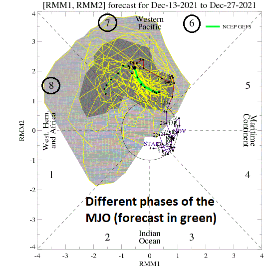
A teleconnection index known as the MJO is expected to push counter-clockwise on this plot from phase 6 into phase 7 and ultimately phase 8. This kind of a change in this tropical pattern often results in a flip of weather from warmer-than-normal to colder-than-normal across the central and eastern US. Map courtesy NOAA
Overview
The weather this week will be quiet across much of the eastern two-thirds of the nation and relatively mild for the middle portion of December. The warmer-than-normal weather this week will likely peak on Thursday in the Mid-Atlantic region with temperatures probably reaching into the 60’s in the DC-Philly-to-NYC corridor. A different story is possible next week, however, as the overall pattern shows some signs of turning colder and potentially stormy in the northeastern part of the nation.

The current pattern in the upper atmosphere feature a strong ridge of high pressure over the Great Lakes which is contributing to a quiet and relatively mild week. The flow aloft across southern Canada is currently preventing any Arctic air to drop southward into the US. Map courtesy NOAA, tropicaltidbits.com
Weekend recap
Temperatures surged on Saturday in the eastern US ahead of an incoming strong cold frontal system which resulted in record-high temperatures in the DC-Philly-to-NYC corridor along with powerful wind gusts. Specifically, temperatures soared to 70 degrees in DC on Saturday, December 11th breaking the old record of 68 degrees set in 1979. In addition, Philly climbed to a record high of 68 degrees breaking the old record of 65 degrees set in 1971 and Central Park in New York City bested their old record of 64 degrees from 1879 by peaking at 66 degrees.

A change in the upper-level wind field next week should allow for the transport of much colder air from northwestern Canada into the northern US. This kind of pattern change would cause a flip from this week’s warmer-than-normal weather in the northern states to colder for next week. Map courtesy NOAA, tropicaltidbits.com
Next few days to be mild, quiet
The next few days will be on the cool side in the Mid-Atlantic region/NE US as high pressure builds across the southeastern part of Canada. However, temperatures will be slightly above-normal for the middle of December with highs likely reaching the low-to-mid 50’s through mid-week. On Thursday, this week’s warm up is likely to peak ahead of the next cold front and temperatures should climb into the 60’s across the DC-to-Philly-to-NYC corridor. The passage of this front will shed a few degrees off on Friday and then another cold front will arrive this weekend. That early weekend front is liable to come with some rainfall and it’s passage will usher in a colder air mass for the second half of the weekend and the early part of next week.

Temperature composite maps are shown on the left for the different phases of the Madden-Julian Oscillation or MJO. Typically, in this time of year, phase 6 results in warmer-than-normal weather across much of the nation and phases 7 and 8 are colder-than-normal. The location of the eastward-moving tropical disturbance is shown by “phase” number of the MJO on the right plot. Courtesy NOAA
Madden Julian Oscillation (MJO) and a cold signal for next week and beyond
One of the supporting signals for a colder pattern next week comes from a teleconnection index value known as the Madden Julian Oscillation or MJO. The MJO can be characterized as an eastward moving “wave” or “pulse” of clouds and enhanced tropical rainfall near the equator that typically recurs every 30-to-60 days. The anomalous rainfall is often first evident over the Indian Ocean, and remains apparent as it propagates eastward over the very warm waters of the western and central tropical Pacific. Over the cooler ocean waters of the eastern Pacific, the pattern of tropical rainfall generally becomes nondescript, but often reappears over the tropical Atlantic and Africa. One method meteorologists use to monitor the MJO is in an 8-phase diagram in which each phase generally coincides with locations along the equator around the globe. In addition to being informative about the location of the MJO, these phase diagrams provide some information to a meteorologist as to the strength of the tropical disturbance as it traverses the tropics. Specifically, when the MJO index is within the center circle of the forecast plots, it is considered to be weak and when it is outside, it is stronger and usually moves in a counter-clockwise direction.
The different phases of the MJO correlate well with different temperature and precipitation patterns around the world depending on the given time of year. The current forecast by two most computer forecast models indicate the MJO will be relatively strong over the next few weeks and likely travel from phase 6 into phase 7 and then ultimately to phase 8. During this time of year, with the MJO in phase 6, generally warmer-than-normal conditions develop in the central and eastern states and this does indeed look like this finding will hold true this week. Phases 7 and 8, however, are typically associated with colder-than-normal conditions in the eastern half of the nation and the forecast of this location for next week and beyond support the idea of a flip from warm-to-cold. In addition, there are signs that the upper atmosphere will be filled with numerous disturbances that can lead to a stormier pattern in the eastern US – certainly when compared to this week – and this combination will keep alive the possibility of a white Christmas…stay tuned.
Meteorologist Paul Dorian
Video discussion: