10:45 AM | *A quiet and relatively mild week continues across the eastern US…California continues to get pounded...some signs for the beginnings of a colder pattern next week across the northern US*
Paul Dorian

A teleconnection index known as the MJO focuses on the tropics and will push counter-clockwise in coming days from phase 6 into phase 7 and ultimately into phase 8. This time of year these phases or locations of a tropical wave often result in a pattern change across the central and eastern US from warmer-than-normal to colder-than-normal. Map courtesy NOAA
Overview
The weather continues to be quiet across much of the eastern part of the nation and relatively mild for the middle portion of December. Meanwhile, a powerful storm is pounding away at California with heavy rainfall along coastal sections and heavy snows across inland, higher elevation locations. This same storm system will push into the central Plains on Wednesday and likely result in a widespread area that will experience record-breaking warmth and also powerful wind gusts of 50-60 mph. In the Mid-Atlantic region, the warmer-than-normal weather will likely peak on Thursday afternoon with temperatures climbing to 60+ degrees in the DC-Philly-to-NYC corridor. Looking ahead, there are several signals that point to a colder weather pattern for the northern US beginning early next week and this same change could also bring about a substantial cold period to eastern Europe/Russia later in the month.

The current pattern in the upper atmosphere features a strong ridge of high pressure over the Great Lakes which is contributing to a quiet and relatively mild week in much of the eastern US. The southwesterly flow aloft across southern Canada is currently preventing any Arctic air to drop southward into the US. Map courtesy NOAA, tropicaltidbits.com
California gets pounded…quiet, relatively mild stretch for the eastern two-thirds of the nation
While California continues to get pounded by a strong storm system, much of the eastern US is enjoying a quiet and relatively mild day as we approach the mid-point of December. The dominating systems in the upper atmosphere include deep low pressure just off the US west coast and very strong high pressure ridging centered over the Great Lakes. The combination of these two systems is producing an upper level flow of air that is preventing any kind of an Arctic air mass to drop into the central and eastern US. The deep trough off the west coast has spawned a very strong storm system that will continue to produce heavy rainfall along coastal sections – even down to San Diego in the far southern part of the Golden State. In the inland higher elevation locations of California, substantial snow is falling and some spots in the Sierra Nevada Mountain Range can end up with as much as 5 feet of snow when all is said and done from this storm at mid-week. This same strong storm system will push into the Central Plains resulting in a widespread area of record-breaking warmth on Wednesday and also powerful wind gusts of 50-60 mph.

A change in the upper-level wind field in about a week’s time should be more favorable for the transport of colder air from northwestern Canada into the northern US. A “blocking” pattern is also likely to develop across Greenland/Iceland by early next week and this system will be a contributing factor to a colder pattern across the northern US and also across much of eastern Europe and Russia. Map courtesy NOAA, tropicaltidbits.com
Next week
The overall upper air pattern will have a different look to it about a week from now. The deep upper air low now off the west coast will tend to retrograde some in coming days and “blocking” high pressure will form over the higher latitudes of Greenland/Iceland. In addition, the strong ridge now centered over the Great Lakes will tend to weaken and drop southward. These changes will result in a change to the wind flow in the upper part of the atmosphere that will be more favorable for the movement of cold air masses from northern Canada into the northern US. The same change in the upper air pattern is likely to bring about a substantial cold period to much of eastern Europe and Russia later this month with some serious cold on the table. In terms of the potential for storms next week across the CONUS, there will be a couple of waves aloft to monitor in coming days that can ultimately result in surface low pressure somewhere in the Gulf/southeastern US. One system will push along in the southern branch of the jet stream and the other will be moving aloft in the northern branch, but, so far, it is too early to say if any kind of “phasing” will take place…something to monitor in coming days.

Temperature composite maps are shown (left) for the different phases of the Madden-Julian Oscillation or MJO. Typically, during this time of year, phase 6 results in warmer-than-normal weather across the eastern two-thirds of the nation and phases 7 and 8 are often colder-than-normal in this same area. The location of the eastward-moving tropical disturbance is shown by “phase” number on the map to the right. Courtesy NOAA
Supporting signals for a pattern change to colder (MJO, NAO, AO)
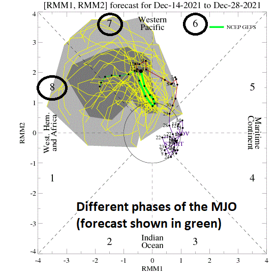
One of the supporting signals for a colder pattern next week comes from a teleconnection index value known as the Madden Julian Oscillation or MJO which has its focus on the tropics. The MJO can be characterized as an eastward moving “wave” or “pulse” of clouds and enhanced tropical rainfall near the equator that typically recurs every 30-to-60 days. The anomalous rainfall is often first evident over the Indian Ocean, and remains apparent as it propagates eastward over the very warm waters of the western and central tropical Pacific. Over the cooler ocean waters of the eastern Pacific, the pattern of tropical rainfall generally becomes nondescript, but often reappears over the tropical Atlantic and Africa.
One method meteorologists use to monitor the MJO is in an 8-phase diagram in which each phase generally coincides with locations along the equator around the globe. In addition to being informative about the location of the MJO, these phase diagrams provide some information to a meteorologist as to the strength of the tropical disturbance as it traverses the tropics. Specifically, when the MJO index is within the center circle of the forecast plots, it is considered to be weak and when it is outside, it is stronger and usually moves in a counter-clockwise direction.

The NAO and AO indices are likely to trend in a downward direction during the next several days often indicative of a “blocking” pattern that forms in the higher latitudes (e.g., Greenland/Iceland). Maps courtesy NOAA
The different phases of the MJO correlate well with different temperature and precipitation patterns around the world depending on the given time of year. The current forecast by two most computer forecast models indicate the MJO will be relatively strong over the next few weeks and likely travel from phase 6 into phase 7 and then ultimately to phase 8. During this time of year, with the MJO in phase 6, generally warmer-than-normal conditions develop in the central and eastern states and this does indeed look like this finding will hold true this week. Phases 7 and 8, however, are typically associated with colder-than-normal conditions in the eastern half of the nation and the forecast of this for next week and beyond support the idea of a flip from warm-to-cold.
In addition to the MJO, support for a pattern change to colder in the central and eastern US comes from a couple of other teleconnection indices that have their focus of attention on the temperature and pressure patterns in the North Atlantic Ocean/Arctic region. The North Atlantic Oscillation (NAO) and its closely-related cousin called the Arctic Oscillation (AO) both should exhibit a downward trend in coming days and this can be signaling a more favorable upper air pattern (i.e., “blocking”) for bringing cold air masses into the central and eastern US from Canada.
Meteorologist Paul Dorian
Video discussion: