10:15 AM | **Active weather pattern next week…strong cold front early…mid-week system threatens Mid-Atlantic/NE US with snow/ice**
Paul Dorian
A powerful cold front will arrive in the eastern states early next week and it’s passage will result in a colder-than-normal air mass across much of the northern US into the mid-week time period. Map courtesy Canadian Met Centre, tropicaltidbits.com
Overview
The month of December is now underway and after a seasonably chilly day on Wednesday, it’ll turn windy and noticeably milder this afternoon with temperatures making a run to 65 degrees in DC, 60 in Philly, and to 55 degrees in NYC. This warm up will be rather short-lived, however, for at least the central and northern part of the Mid-Atlantic region as the next cold front will usher in chillier air for tomorrow and the upcoming weekend. The weather pattern for next week looks quite active with a strong cold front arriving in the eastern states early and then two systems could follow – one at mid-week and the second one in the late week. The cold air mass in the northeastern states that arrives early next week will be reluctant to retreat to the north and this could result in some snow and/or ice by mid-week in portions of the Mid-Atlantic and Northeast US.
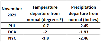
Temperatures were slightly colder-than-normal in the DC-to-Philly-to-NYC corridor during the month of November and it was considerably drier-than-normal. Data courtesy NOAA
Details
The month of November ended as slightly colder-than-normal in the Mid-Atlantic region and considerably drier-than-normal. The month of December started off pretty close-to-normal on Wednesday, but it’ll turn well above-normal later today following the passage of a warm frontal system. In fact, temperatures could approach the 65 degree mark for afternoon highs in DC, 60 degrees in Philly, and to near 55 degrees in the NYC metro region.
The 00Z Canadian forecast map for next Wednesday features some snow (in blue) across the Mid-Atlantic/Northeast US. Map courtesy Canadian Met Centre, tropicaltidbits.com
Winds will also become a factor later in the day from a west-to-southwesterly direction with gusts past 30 mph likely as low pressure strengthens to our north. That same system will then drag a cold front through the Mid-Atlantic region later tonight and it’ll turn chillier on Friday; especially, across the central and northern portions of the Mid-Atlantic and the Northeast US.
Two upper-level disturbances may interact next mid-week to produce precipitation in the Mid-Atlantic/NE US and then a late week system is possible as it pulls out of the SW US and moves to the northeast. Map courtesy ECMWF, Weather Bell Analytics
Another strong cold front will push into the eastern states early next week. Showers are likely to accompany the arrival of this front on Monday and temperatures should drop noticeably by Monday night and Tuesday as NW winds intensify following the passage of the strong cold front. At that point, attention will turn to a couple of upper-level disturbances over the mid-section of the country as they could help to draw moisture into the northeastern states at mid-week. The cold air mass that arrives early next week will likely be somewhat reluctant to give up its ground so if the moisture pushes in quick enough, snow and/or ice can break out at mid-week in portions of the Mid-Atlantic and Northeast US. Icing is indeed a legitimate threat with this mid-week system as low-level cold, dense air will tend to hang around longer than aloft - leading to the possibility of sleet and/or freezing rain in some areas. One thing to also keep in mind for this mid-week threat is that computer forecast models tend to predict a retreat of the cold, dense air too quickly.
The best chance for anything frozen next mid-week will be in higher elevation, interior sections of the Mid-Atlantic/Northeast US and some decent accumulating snow is certainly on the table for interior New England. Another system could quickly follow for the late week time period and there can still be some cold air holding on across portions of the northeastern states leading to more interesting possibilities…stay tuned, lots of players on the field making for a difficult forecast…something we’ll have to monitor in coming days.
Meteorologist Paul Dorian
Video discussion:


