
1:45 PM | ***An active weather pattern continues...an early weekend strong storm with wide-ranging impacts...second storm could follow on Sunday night/Monday morning in eastern US***
Paul Dorian

A large temperature contrast exists across the nation today and very strong winds aloft are separating the cold air to the north and west and the warm air to the south and east. This type of pattern with strong winds in the upper atmosphere will continue into the weekend and it could help to spawn some severe weather on Saturday across the Lower Mississippi and Tennessee Valleys. Map courtesy NOAA, tropicaltidbits.com
Overview
An active weather pattern will continue across much of the nation during the next few days and indeed it is likely to last right through the upcoming New Year’s Day weekend. A huge difference in temperatures currently exists across the country from northwest-to-southeast and it is helping to fuel this activity with multiple low pressure systems to deal with as we head into the new year. A strong storm system on Saturday could have wide-ranging impacts from rainy, unusually mild conditions in much of the eastern US, severe weather in the Lower Mississippi and Tennessee Valleys, and accumulating snow from Colorado to Michigan. There is a chance that a follow-up storm takes place at the end of the weekend in the eastern US as sharply colder air pushes in from the northwest….something to monitor closely in coming days.
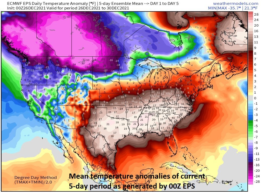
This current 5-day time period will feature tremendous temperature differences across the nation from unusual warmth in the south-central and southeastern states to “off-the-charts” type of cold weather from the Pacific Northwest to the Dakotas. Map courtesy NOAA, weathermodels.com (Dr. Ryan Maue, Twitter)
Details
Temperatures at mid-day are some 50+ degrees different from Texas-to-Montana and this contrast across the nation is helping to fuel very strong winds in the upper atmosphere and is contributing to an overall active weather pattern that looks like will continue through the upcoming weekend. There has been persistent colder-than-normal weather in recent days from California to the Dakotas and northwestward to the southwestern part of Canada.
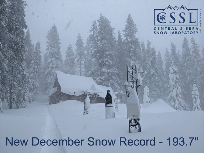
Good news for the California water supply…the Sierra Nevada Mountains have developed a tremendous snowpack in recent days to well above-normal levels and, in some spots, to record-breaking amounts for the month of December…and more accumulating snow is on the way. Data courtesy CSSL
The recent sustained colder-than-normal weather pattern in the western US has resulted in plenty of snowfall for higher elevation locations and some incredible amounts in the Sierra Nevada Mountains of eastern California. With the most recent snowfall, a record for the month of December has been achieved at the Central Sierra Mountain Snow Lab (CSSL) with 193.7 inches – smashing the old record of 179 inches set in December of 1970 - and more accumulating snow is on the way. The snowpack in the Sierra Nevada Mountains accounts for ~30 percent of the fresh water supply across California through snowmelt during the subsequent summer season.
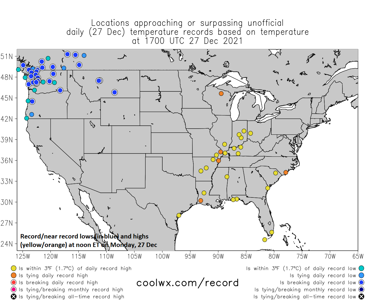
Temperatures at mid-day on Monday, December 27th featured some record or near record lows in the northwestern states and record or near record highs in the Mississippi Valley/Southeast US. Map courtesy coolwx.com, NOAA
Meanwhile, in the south-central and southeastern US, temperatures are running some 20+ degrees above normal. Rainfall totals over the next 7 days or so will likely surpass 5 inches in places like the Tennessee Valley where temperatures will remain at well above normal levels right into the weekend. On Saturday, a strong storm will pull up towards the Great Lakes and the Lower Mississippi and Tennessee Valley regions will be in the warm sector and - given the very strong winds that are expected in the upper atmosphere and the unusual warmth in the lower atmosphere - a severe weather outbreak is on the table. Severe weather during the wintertime is not all that unusual during “La Nina” winters in which sea surface temperatures run at colder-than-normal levels across the equatorial Pacific Ocean. In the cold sector, accumulating snow can fall on Saturday all the way from Colorado to Michigan with places like Chicago and Detroit possibly in store for their biggest snowfalls so far this season.

New Year’s Day (Saturday) is likely to feature a strong storm system with wide-ranging impacts from accumulating snow in the Upper Midwest, severe weather in the Lower Mississippi/Tennessee Valleys, and rainy, very mild conditions in much of the eastern US. Map courtesy NOAA, tropicaltidbits.com
By late in the weekend, we’ll have to watch for the possibility of a second storm system working its way into the eastern US as a powerful cold front arrives from the northwest. There will be an impressive second wave of energy rotating through the base of an upper-level trough and this could help to spawn a late Sunday into early Monday storm system somewhere near the east coast. If this second storm were to actually form, there would be some noticeably colder air pressing to the south and east into the eastern states around the end of the upcoming weekend and this could make for some interesting weather - perhaps in places like the Mid-Atlantic region - still several days away, but this active late weekend frontal passage will be something to closely monitor in coming days.
Meteorologist Paul Dorian
Arcfield
arcfieldweather.com
Follow us on Facebook, Twitter, YouTube
Video discussion: