12:50 PM | **An active pattern coming…strong cold front arrives on Monday with powerful winds...some snow at mid-week in the Mid-Atlantic region*
Paul Dorian
A large colder-than-normal air mass will from the Northern Plains to New England next mid-week and at the same time moisture from the south-central states will head to the northeast. Map courtesy Canadian Met Centre, tropicaltidbits.com
Overview
The weather pattern for next week looks quite active with a strong cold front arriving in the eastern states on Monday and then a low pressure system to follow at mid-week. The cold air mass that arrives early next week in the Mid-Atlantic/NE US will be reluctant to give up its ground as soon as mid-week and this could set the stage for some accumulating snow and ice in portions of the Mid-Atlantic/NE US.
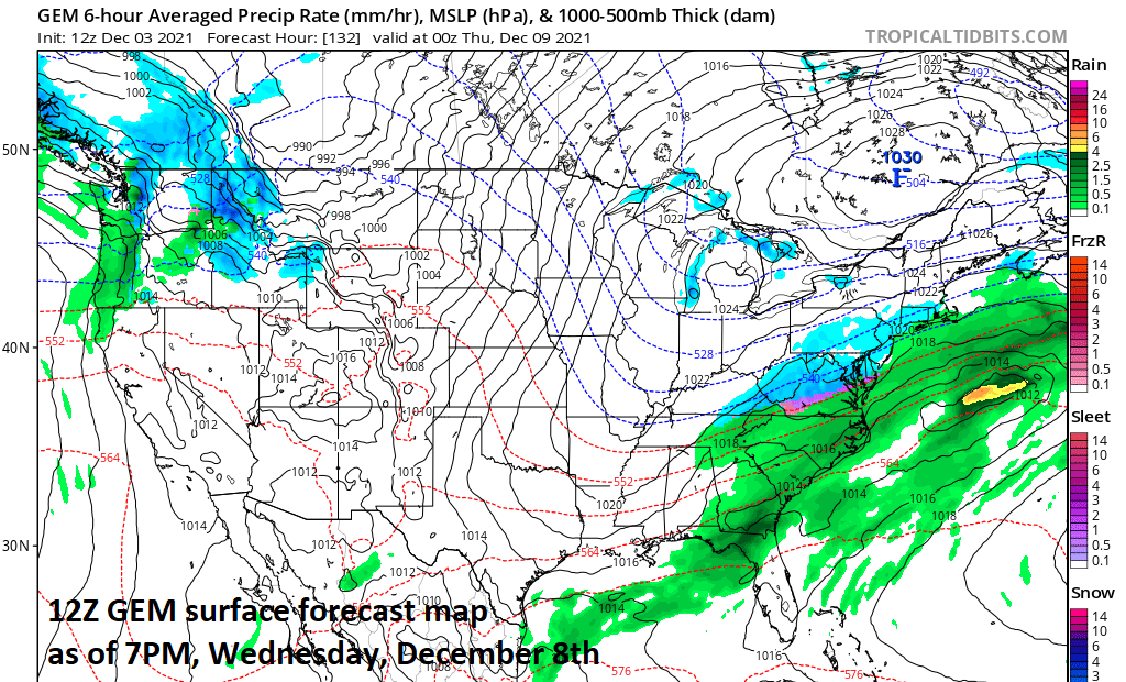
Cold high pressure to the north next Wednesday morning can help to “lock-in” the cold air mass as precipitation arrives from the southwest. Map courtesy Canadian Met Centre, tropicaltidbits.com
Discussion
A strong cold front will push southeastward across the Great Lakes later this weekend and arrive in the eastern states on Monday. Showers are likely to accompany the arrival of this front on Monday and it should be quite mild and breezy ahead of the system. Temperatures should drop noticeably after its passage by Monday night and Tuesday and NW winds will be quite strong.
Snow (shown in blue) on the forecast map next Wednesday morning for parts of the Mid-Atlantic/NE US. Map courtesy Canadian Met Centre, tropicaltidbits.com
At that point, attention will turn to a couple of upper-level disturbances over the mid-section of the country as they could help to draw moisture into the northeastern states at mid-week. The cold air mass that arrives early next week will likely be reluctant to give up its ground as soon as mid-week; especially, if strong high pressure builds to the north across southeastern Canada and that is a strong possibility. As a result, if the moisture pushes in quick enough on Wednesday, snow can break out in portions of the Mid-Atlantic and Northeast US and accumulations are on the table. Sleet and/or freezing rain are indeed also legitimate threats with this mid-week system in some areas as the low-level cold, dense air will tend to hang around longer than the cold air aloft – an atmospheric condition conducive to icing. Stay tuned…still several days to go on this potential mid-week accumulating snow and ice event.
Meteorologist Paul Dorian


