11:00 AM | *Strong cold front arrives late today with powerful winds…some snow possible at mid-week in the Mid-Atlantic/Northeast US...another active front this weekend*
Paul Dorian
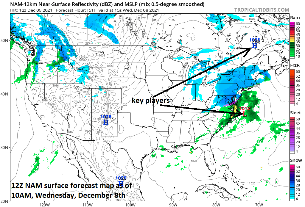
Two key players at the surface for the mid-week snow possibilities in the Mid-Atlantic/NE US will be high pressure across southeastern Canada and low pressure off the Mid-Atlantic coastline. Map courtesy NOAA, tropicaltibits.com
Overview
A strong cold front will arrive in the eastern states late today and its passage will set the stage for some snow at mid-week in the Mid-Atlantic region and Northeast US. It’ll turn very windy and much milder today just ahead of the front along with a few rain showers. Temperatures will drop sharply in the overnight hours behind the front as the strong winds shift to a northwesterly direction. After a cold, dry and much less windy day on Tuesday, low pressure will push to a position off the Mid-Atlantic coastline by early Wednesday morning. The fresh cold air mass that arrives shortly following the passage of the front will maintain its ground at mid-week allowing for primarily snow in the Mid-Atlantic/Northeast US and minor accumulations are on the table.
A key player in the upper atmosphere on Wednesday will be a “spread out” disturbance that will try to “consolidate” as it heads to the Mid-Atlantic region. If it indeed fails to “consolidate”, the low pressure system will remain on the weak and any snow that falls will likely be very limited in scope. Map courtesy NOAA, tropicaltidbits.com
Cold blast…mid-week possible snow
A strong cold front is pushing southeastward today across the Great Lakes and will reach the eastern seaboard by early tonight. It’ll become very mild and windy today on the front side of the cold front with SW wind gusts possible to 40 mph. Temperatures will drop sharply in the overnight hours behind the front and NW winds can gust to 40 mph or so. Rain showers can break out at any time today, but are probably most likely late in the day or early tonight with the arrival of the surface front.
A cold air mass will hold its ground at mid-week in the Mid-Atlantic/NE US thanks to high pressure across southeastern Canada and the favorable (for cold) positioning of low pressure off the Mid-Atlantic coastline. Map courtesy NOAA, tropicaltidbits.com
On Tuesday, high pressure will build across the Mid-Atlantic region and winds will die down noticeably compared to today and it’ll be much colder. This same high pressure system will shift northward into southeastern Canada by Wednesday at the same time low pressure starts to form near the Carolina coastline. Another key player on Wednesday will be an upper-level disturbance that will attempt to “consolidate” as it pushes to the eastern seaboard and the ability of this will be important on overall precipitation shield. If the upper-air support remains “stretched-out” - the going bet at this point - the snow on Wednesday will be limited in scope with only minor accumulations. The combination of the high pressure system building across southeastern Canada and low pressure headed to the south and east of the I-95 corridor will allow for the cold air to hold its ground on Wednesday in the DC-to-Philly-to-NYC corridor setting the stage for whatever falls to be primarily in the form of snow. The range of snow accumulations for this mid-week event will be from a dusting on the low side to an inch or two on the high side…stay tuned for some “fine-tuning” over the next 12-24 hours.
Very mild air is likely to push into the eastern third of the nation on Saturday ahead of the next strong cold front. Showers could accompany this weekend frontal system and there is even a chance for some strong-to-severe thunderstorm activity. Map courtesy NOAA, tropicaltidbits.com
Another active front arrives this weekend
Looking beyond the mid-week snow, it’ll stay cold on Thursday, but then turn milder on Friday to end the work week. On Saturday, another strong cold front will be heading eastward across the nation’s mid-section and towards the eastern states. As a result, it’ll turn very mild and windier on Saturday ahead of this next incoming strong frontal system. Low pressure could form along this next frontal boundary zone enhancing the possibility for some heavy rainfall this weekend - perhaps even some unusual strong-to-severe thunderstorm activity.
Meteorologist Paul Dorian
Video discussion:


