
10:30 AM | ***A surge of record-breaking warmth on Saturday in the eastern states with powerful and potentially damaging winds***
Paul Dorian

Temperatures could soar to near 70 degrees in portions of the I-95 corridor on Saturday which will put many records in jeopardy including in the DC, Philly and NYC metro regions. Map courtesy NOAA, tropicaltidbits.com
Overview
While the weather today is pretty cold in the Mid-Atlantic and Northeast US with a touch of snow in some spots, a big warm up is coming by the weekend and the bulk of next week looks to be on the warm side of normal as we head towards the middle part of December. In fact, the surge of warmth expected this Saturday is likely to come with record high temperatures in much of the eastern US including along the DC-to-Philly-to-NYC corridor. Temperatures could actually soar towards the 70 degree mark in DC and Philly and climb into the middle 60’s in NYC – all well above-normal for this time of year and all would threaten record highs. This surge of record-breaking warmth will come ahead of the next strong cold front which can produce severe thunderstorms on Friday in the Mississippi Valley and even some strong thunderstorm activity later Saturday in the eastern states.

On Saturday, December 11th, many high temperature records could fall in the eastern states. A surge of unusual warmth for this time of year will push into the Mid-Atlantic/NE US ahead of the next advancing cold frontal system. Following the passage of the cold front, temperatures will drop significantly on Sunday after what is likely to be a record-breaking day on Saturday. Map courtesy NOAA, tropicaltidbits.com
Discussion
Following today’s cloudy, cold day in the Mid-Atlantic/NE US, temperatures will remain below-normal on Thursday and there will likely be a good deal of cloud cover. Following the passage of a warm front on Thursday night, temperatures will begin a noticeable upturn on Friday with afternoon highs likely some ten degrees or so above the Thursday PM levels.
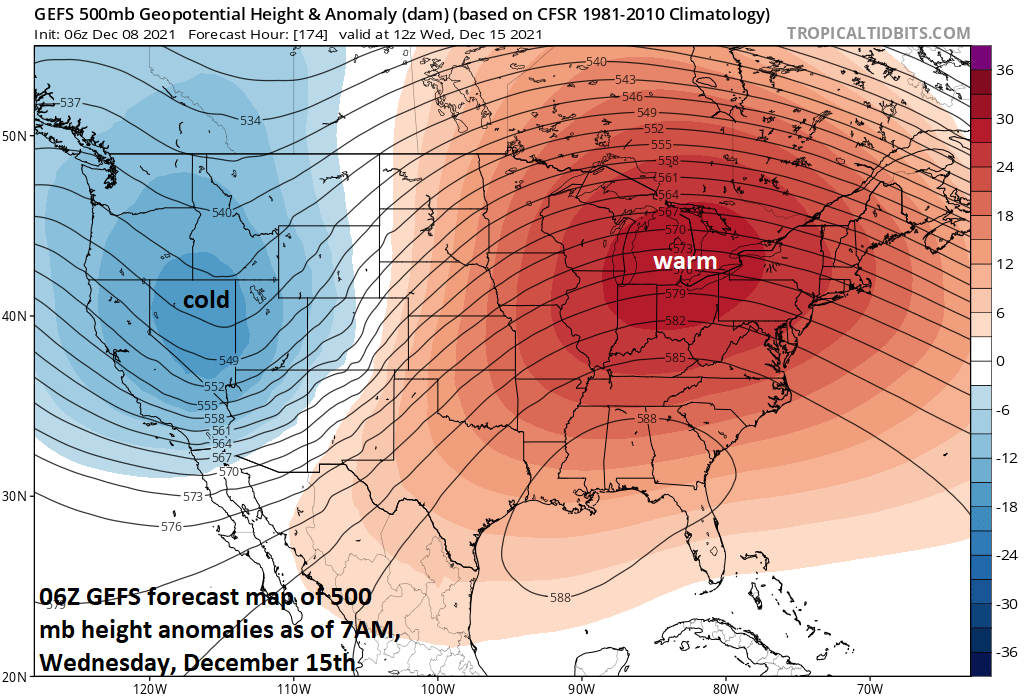
The overall pattern will be on the warm side of normal next week across the eastern two-thirds of the nation as strong ridging pops up aloft centered over the Great Lakes. The only colder-than-normal weather later next week will be confined to the western states where a deep upper-level trough of low pressure forms. Map courtesy NOAA, tropicaltidbits.com
It is on Saturday when the temperatures could then go “off to the races” in the eastern states as a long fetch of southwesterly flow of air will funnel unseasonably warm air into the Mid-Atlantic/NE US from the southeastern states. This warm surge on Saturday will take place on the front side of an advancing cold frontal system and daily records for December 11th could fall in many spots. For example, the record at Reagan National Airport (DCA) for December 11th is 68 degrees (1979) and temperatures in that region could soar to the 70 degree mark on Saturday. In addition, Philly’s record high on December 11th is 65 degrees (1971) and this record could actually be beaten by a few degrees. The record in New York City’s Central Park is 64 degrees set way back in 1879 and this too is in jeopardy.

The next strong cold front can result in some strong-to-severe thunderstorm activity on Friday across the Mississippi Valley accompanied by the unseasonably warm conditions. Some of this thunderstorm activity could work its way in the eastern states later Saturday. Map courtesy NOAA/SPC
The advancing strong cold front is likely to result in severe thunderstorm activity on Friday in the Mississippi Valley to go along with the surge of warmth. Some strong thunderstorms can then develop in the eastern states later Saturday as the cold front continues to advance to the east. This next strong cold front will likely off the east coast on Saturday night paving the way for noticeably colder conditions on Sunday in the Mid-Atlantic/NE US. However, the overall pattern remains rather warm for the bulk of next week and the incoming early week chill in the east should be rather short-lived. By the middle of next week, temperatures are likely to be well above-normal in much of the eastern 2/3rds of the nation with only the western states likely to feature colder-than-normal conditions.
Meteorologist Paul Dorian
Video discussion: