
1:00 PM | ***Second half of the week event comes in two waves (Wednesday PM/Thursday AM; Thursday PM/Friday AM)…heaviest snow likely to be suppressed to the south of the PA/MD border***
Paul Dorian

There is the threat for a wintry mess this weekend in the Mid-Atlantic region which could involve snow, sleet and rain. This system could be the catalyst for pushing some very cold air into the DC-to-Philly-to-NYC corridor by Monday morning with “single digit” cold on the table. Map courtesy NOAA, tropicaltidbits.com
Overview
The second half of the week will feature two waves of precipitation for the Mid-Atlantic region with one wave coming from Wednesday night into early Thursday and the second from later Thursday into mid-day Friday. It appears that the heaviest snow associated with both of these systems will be suppressed to areas south of the PA/MD border across Virginia, Maryland, southern Delmarva, and southern New Jersey. The DC metro region will likely be right in or very close to the zone with the heaviest snow and there should be less impact to the northeast in places like Philadelphia and New York City. Another winter storm system may impact the Mid-Atlantic region this weekend and passage early next week could be the catalyst for an intrusion of bitter cold air into the DC-to-Philly-to-NYC corridor. And yes, there may be another winter storm threat for the Mid-Atlantic region by the middle of next week. Unfortunately, the potential threats coming this weekend and by the middle part of next week present the possibility of significant icing issues in parts of the Mid-Atlantic region.

A “battle zone” in the atmosphere has formed between deep (cold) upper-level low over northern US/southern Canada and a ridge of high pressure (warm) in the southeastern US. The Mid-Atlantic region will be right in the middle of this “battle zone” with multiple systems to deal with in coming days. Map courtesy NOAA, tropicaltidbits.com
Details
The combination of the deep upper low across southern Canada/northern US and an expanding ridge of high pressure in the southeastern states is setting up a “battle zone” region in a general west-to-east fashion across the mid-section of the nation and this active zone includes the Mid-Atlantic region. The upcoming weather pattern will be active and rather complicated with multiple waves of energy to deal with potentially having an impact on at least portions of the Mid-Atlantic region. One such system is producing some snow today across upstate Pennsylvania, northern New Jersey and southeastern New York and scattered rain showers over the Delmarva Peninsula and southern New Jersey. Another couple of waves of energy will have an impact on the Mid-Atlantic region later in the week and there will be plenty of cold air around increasing the chance for accumulating snow all the way down into the DC metro region.

The Thursday morning forecast map by the 12Z GFS model run with snow (in blue) in much of the Mid-Atlantic region to the north of the DC metro region. Map courtesy NOAA, tropicaltidbits.com
The first wave will have an impact from tomorrow night into Thursday morning and while it is likely to produce snow in the DC-to-Philly-to-NYC corridor, somewhat higher amounts are likely to take place to the south of the Mason-Dixon Line. This initial wave does not look all that significant, but small accumulations are certainly on the table for the DC-to-Philly-to-NYC corridor by mid-day Thursday.
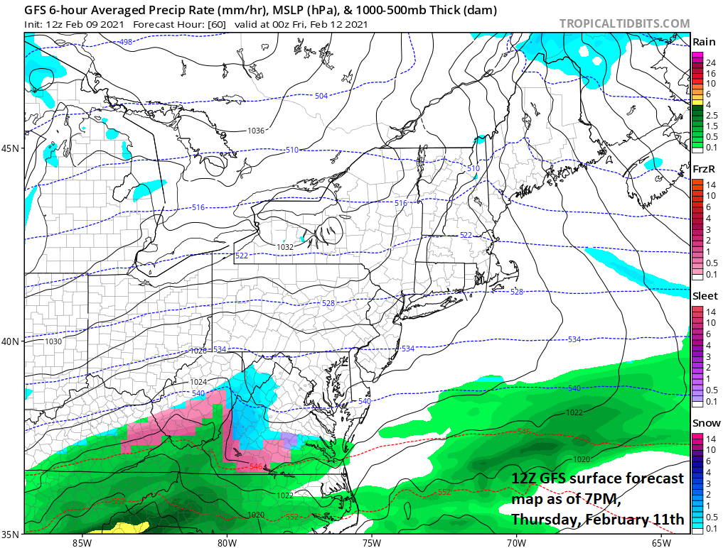
The Thursday early evening forecast map by the 12Z GFS model run with (temporary) dry conditions in the DC-to-Philly-to-NYC corridor (i.e., between waves). Map courtesy NOAA, tropicaltidbits.com
Strong high pressure to the north on Thursday will then build into the Mid-Atlantic region and the first system will get pushed to the southeast and there will be a break in the action before another system arrives. Similar to the initial wave, this second system looks like it’ll produce more snowfall south of the PA/MD border in places like Washington, D.C. and lesser amounts in Philly and NYC. This timetable for the second system will be from later Thursday into the mid-day hours on Friday. As far as snow totals are concerned, preliminary estimates for both of these systems combined is 1-3 inches in Philly and NYC and 3-6 inches in the DC metro region.

The Friday morning forecast map by the 12Z GFS model run with snow (in blue) in southern PA, northern VA/MD and DC metro region. Map courtesy NOAA, tropicaltidbits.com
Looking ahead
The weekend could feature a strong high pressure system over the Northern Plains with intense and widespread cold in the northern and central US extending from Montana-to-Michigan and from Minnesota all the way down to Texas. There is also likely to be quite a bit of moisture gathering across the south-central and Gulf coastal states. There are signs that this moisture will push to the north and east later in the weekend and into the Mid-Atlantic region where there will likely be a retreating cold air mass. In other words, there is the chance for a wintry mess of snow, ice and/or rain in the Mid-Atlantic from later Saturday into early Sunday - potentially even significant icing in parts of the region. After the departure of this system, some of the very cold air to our north and west could push into the DC-to-Philly-to-NYC corridor with “single digit” cold possible on Monday morning. Beyond that, yes, there may be yet another winter storm threat by the middle of next week that could feature a storm system coming out of the Gulf of Mexico and moving up along the eastern seaboard.
Meteorologist Paul Dorian
Perspecta, Inc.
perspectaweather.com
Follow us on Facebook, Twitter, YouTube
Video discussion: