
12:30 PM (Monday) | *Winter is hanging on in much of the nation…a couple of chances of frozen precipitation this week in the Mid-Atlantic/Northeast…recap of the blockbuster Rockies snowstorm*
Paul Dorian

A blocking pattern across southern Canada will “force” low pressure to head towards the Mid-Atlantic coastline by week’s end after initially arriving in the Ohio Valley. This turn to the southeast will allow for colder air to drop to the southeast potentially resulting in a “rain-changing to snow” scenario for parts of the interior Mid-Atlantic/Northeast US on Friday. Map courtesy tropicaltidbits.com, Canadian Met Centre (GEPS forecast map of 500 mb height anomalies)
Overview
It is now the middle of March and the spring equinox is less than a week away, but winter is still hanging on in many portions of the nation. There are actually two chances of frozen precipitation this week in the Mid-Atlantic/Northeast US and the past couple of days has seen a blockbuster snowstorm in the Rockies that indeed turned out be one of the all-time greats in places like Denver, Colorado and Cheyenne, Wyoming.
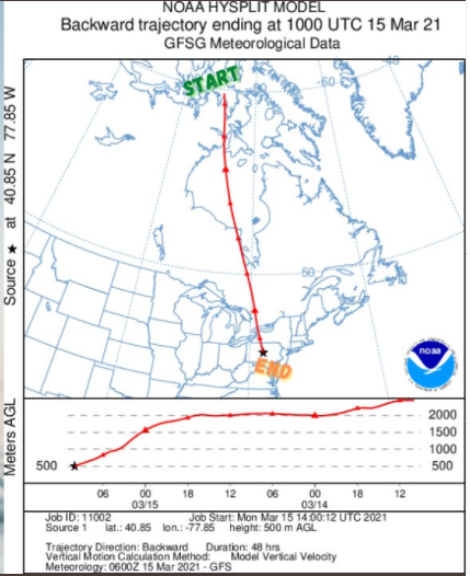
The cold and extremely dry air mass that is now in the Mid-Atlantic region had its origins way up in northern Canada according to this “backward” trajectory plot. Courtesy NOAA/Hysplit Model
Mid-Atlantic/Northeast US snow chances
The new work week has begun with a cold and extremely dry air mass in the northeastern quadrant of the nation with temperatures at mid-day generally in the 30’s. Dew point temperatures are at very low levels near zero in many spots reflecting the very dry nature of this colder-than-normal air mass that pushed into the Mid-Atlantic region last night on strong NW winds. The dew point temperature is a direct measure of moisture content in the atmosphere (i.e., the lower the dew point, the lower the moisture content).

Very low dew points across the Mid-Atlantic/Northeast US at mid-day indicative of an extremely dry and cold) air mass. Observation courtesy NOAA/Philly NWS
Meanwhile, moisture that is pushing east today from the Rockies is resulting in accumulating snow in the central Plains and some rain and strong thunderstorms across the Tennessee and Mississippi Valleys. This moisture will break up some as it arrives in the Mid-Atlantic/Northeast US on Tuesday, but enough is likely to hold together for a bit of light precipitation on Tuesday and Tuesday night as low pressure tries to form off the Mid-Atlantic coastline. With the cold and very dry air mass in place, the chances for some frozen light precipitation are fairly high in the Mid-Atlantic region; especially, to the north of the PA/MD border.
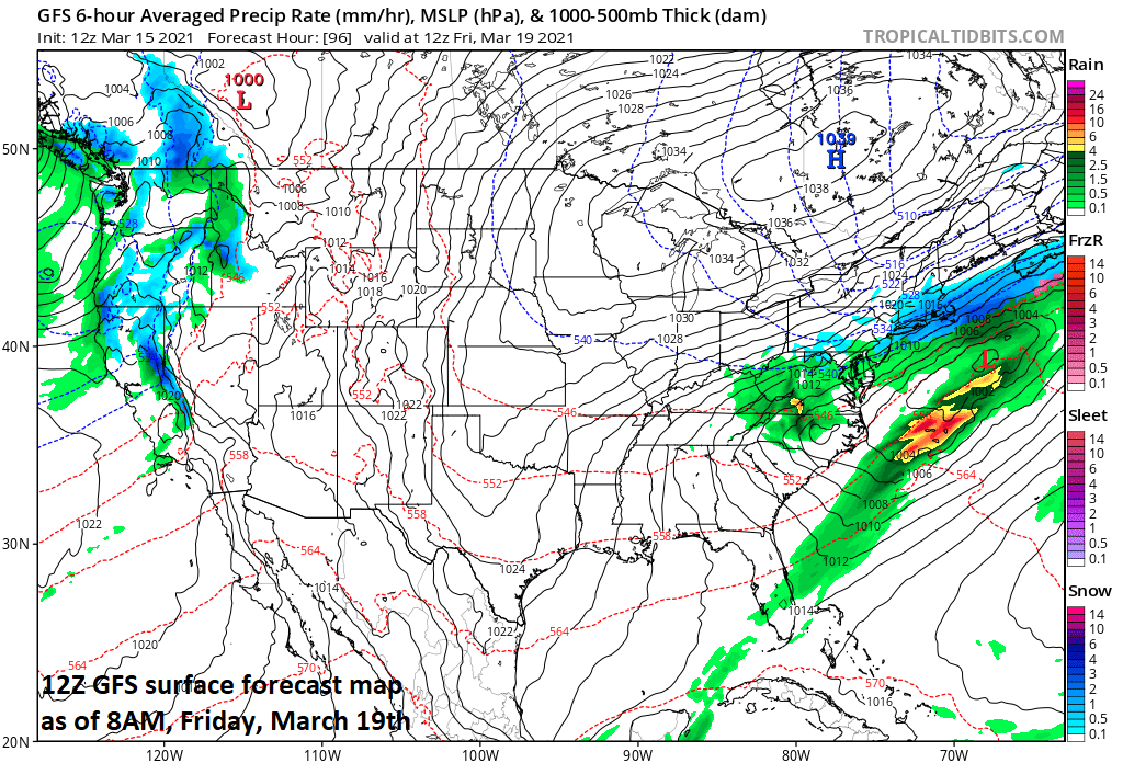
Low pressure will end up off the Mid-Atlantic on Friday and colder air will drop to the southeast into the Mid-Atlantic/Northeast US supported by high pressure over SE Canada. As a result, rain can change to snow on Friday; especially, across interior higher elevation locations. Map courtesy NOAA, tropicaltidbits.com
After a weak system produces a light wintry mix on Tuesday and Tuesday night, a much more significant precipitation event is likely in the Mid-Atlantic/NE US later this week. Strong low pressure system will push into the Rockies by mid-week and then head into the Ohio Valley by Thursday. At the same time, strong blocking will be in place across south-central and southeastern Canada and this will impact the approaching low pressure system by not allowing it to push any farther north than the Ohio Valley. In fact, once this late week low pressure system reaches the Ohio Valley, it will be suppressed to the southeast and likely eventually exit off the Mid-Atlantic coastline. As a result, rain that develops on Thursday in the Mid-Atlantic/Northeast US could end up changing briefly to snow on Friday as colder air drops southeastward from Canada. Strong high pressure will build into southeastern Canada at week’s end pushing another chilly air mass into the northeastern quadrant of the nation leading into the upcoming weekend. The best chance for the changeover to snow on Thursday night and Friday will be in the interior, higher elevation locations of the Mid-Atlantic/Northeast US…something to monitor next few days.

Hourly observations from Denver’s International Airport during the height of the storm…a snow-lover’s delight. Observations courtesy NOAA/NWS
Recap of the blockbuster snowstorm in the Rockies
The weekend snowstorm in the Rockies has indeed turned out to be one of the all-time greats in the Denver-to-Cheyenne corridor and in the higher elevation locations just to the west. The final tally at Denver’s International Airport of 27.1 inches was their 4th biggest snowstorm on record and the 30.8 inches of snow measured in Cheyenne was their most on record. Elsewhere in Colorado, Boulder received 20.7 inches of snow, 40 inches was measured at Aspen Springs, and Buckhorn Mountain came in with a whopping 42 inches. The heavy snowfall extended into the central Plains as well with nearly 20 inches recorded in parts of northwestern Nebraska. Another upper-level trough of low pressure will follow quickly during the next 24-48 hours and it’ll result in more accumulating snow for the Colorado Rockies…good skiing for quite awhile.
Meteorologist Paul Dorian
Perspecta, Inc.
perspectaweather.com
Follow us on Facebook, Twitter, YouTube
Video discussion: