
11:30 AM (Thurs) | *Numerous ingredients coming together for a severe weather outbreak from Deep South-to-Tennessee Valley-to-Ohio Valley…50+ mph wind gusts in the Mid-Atlantic region on Friday*
Paul Dorian

One of the ingredients contributing to the severe weather threat today will be a strong jet streak in the lower levels of the atmosphere (850 mb). Map courtesy NOAA, tropicaltidbits.com
Overview
The first significant severe weather outbreak of the season took place last week across the Deep South and Tennessee Valley with more than 50 tornadoes recorded and there will be a repeat performance today in much of the same general part of the country. Numerous ingredients are coming together for a widespread severe weather outbreak from later today into tonight extending from the Deep South-to-the Tennessee Valley-to-the Ohio Valley. The focus of the action today will likely be in states like Mississippi, Alabama and Tennessee where severe weather can include large hail, damaging wind gusts and several long-track strong tornadoes. The system that is the main culprit behind today’s severe weather outbreak will push into the eastern Great Lakes by later tonight and winds could gust past 50 mph on Friday in the Mid-Atlantic region.

The outlook for severe weather on Thursday and Thursday night is shown on this map as forecasted by NOAA’s Storm Prediction Center.
Numerous ingredients coming together for a widespread severe weather outbreak
A strong wave of energy in the upper part of the atmosphere will pull out of the south-central states and head into the Mississippi Valley and it’ll take on a “negatively-tilted” trough axis orientation (i.e., trough axis extends from northwest-to-southeast). As a result, upward motion will become very strong in the Deep South/Tennessee Valley and this will result in a rapidly strengthening surface low pressure system that will push to the northeast today across the Mississippi Valley.
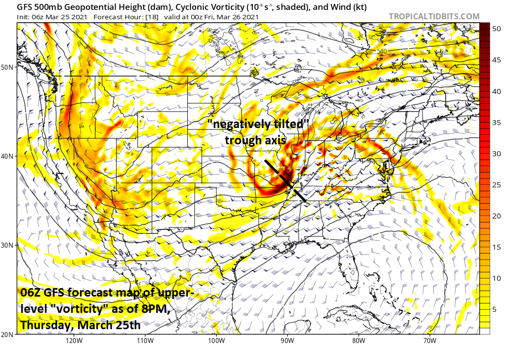
A “negatively-tilted” upper-level wave will support strong upward motion across the Mississippi and Tennessee Valleys contributing to a widespread severe weather outbreak. Map courtesy NOAA, tropicaltidbits.com
In addition, a frontal system will extend from the Ohio Valley to the Gulf States and this will separate colder-than-normal air to its west and very warm and humid low-level air to its east that will be pushing northward from the Gulf of Mexico. On top of the low-level very warm and humid air will be some dry air that will feed into the system from the southwestern states and this combination will help to destabilize that atmosphere. Yet another ingredient will be a strong low-level jet streak (at 850 millibars) that will add to the threat for damaging wind gusts and it’ll contribute to wind shear in the severe weather threat zone region.

“Updraft helicity” as depicted here for early this evening by a high-resolution model known as the “HRRR” indicates there is a threat for long-tracked tornadoes. Map courtesy NOAA/SPC
In terms of the threat of tornadoes, computer forecast models support the notion of discrete supercells which will be capable of multiple tornadoes. In addition, there are signs for long-tracked tornado formation during this outbreak capable of strong-to-violent tornadoes (i.e., EF 2-5) with considerable destructive potential. Forecast wind fields suggest any sustained supercells and their tornadoes will be fast-moving (45-55 knots) with individual tornado paths nearly as long in miles as their duration in minutes.

Very strong winds in the lower levels of the atmosphere will translate to the Mid-Atlantic by early tomorrow likely resulting in 50+ mph wind gusts. Map courtesy NOAA, tropicaltidbits.com
50+ mph wind gusts in the Mid-Atlantic region on Friday
By later tonight, the system will push towards the eastern Great Lakes and the threat for severe weather will continue in the Ohio Valley and winds can gust to 60 mph or so in the Midwest/Ohio Valley. The threat for damaging winds will translate to the Mid-Atlantic region on Friday – just ahead of the advancing frontal system – and winds can gust past 50 mph. Winds will continue to be quite strong tomorrow night across the Mid-Atlantic, but much of the eastern and southern US will experience much calmer conditions on Saturday.
Meteorologist Paul Dorian
Perspecta, Inc.
perspectaweather.com
Follow us on Facebook, Twitter, YouTube
Video discussion: