11:55 AM (Tuesday) | *Winter is not going away without a fight…nor’easter can bring accumulating snow to portions of the Northeast US…additional cold air outbreaks to follow through April*
Paul Dorian
Not only is a chilly air mass coming to the Northeast US later in the week, it appears as though multiple cold air outbreaks will reach the central and eastern US from Canada right through the remainder of the month of April. Maps courtesy NOAA, tropicaltidbits.com
Overview
Just when most people desire the sustained warmth that spring can offer this time of year, the unfolding weather pattern says not quite yet – at least not for much of the central and eastern US. Not only is a chilly air mass coming for later this week, it appears there may be multiple cold air outbreaks for the central and eastern US as we progress through the remainder of the month of April. In addition to the chill, a late week nor’easter can bring accumulating snow to interior, higher elevations of the Northeast US as winter is simply not going away without a fight.
Not exactly a “warm” look to the 12Z NAM forecast map for Friday morning with snow (shown in blue) across much of the interior Northeast US. Map courtesy NOAA, tropicatidbits.com
Details
The teleconnection index known as the North Atlantic Oscillation (NAO) fell into negative territory last week and it has been sustained in that zone for several days now. This index is correlated with the temperature and pressure patterns of the North Atlantic and when it is sustained in negative territory this time of year, the Northeast US usually suffers with some early spring chill. Indeed, a strong blocking pattern has formed in the upper part of the atmosphere across northeastern Canada and Greenland and this is usually part of the overall pattern that brings cold air masses in the central and eastern states from central Canada.
Deep upper-level low pressure will spin its way from the Great Lakes to the Northeast US by Friday, April 16th and will play a major role in the formation of a nor’easter later in the week. Map courtesy NOAA, tropicaltidbits.com
This next shot of chilly air coming later this week originated in Alaska where many spots experienced some of their lowest temperatures ever for the month of April. This air mass has made its way south and east in a modified form – thanks to the overall upper air pattern over North America – and it will chill down the central and eastern US in coming days. To make matters worse, it looks like this next shot of chilly air will be followed by multiple other cold air outbreaks for the central and eastern states as we progress through the remainder of April.
Not only will there be some unusual accumulating snow in the Northeast US in coming days, but the Rocky Mountain States are likely to receive some significant snowfall as well. Map courtesy NOAA, tropicaltidbits.com
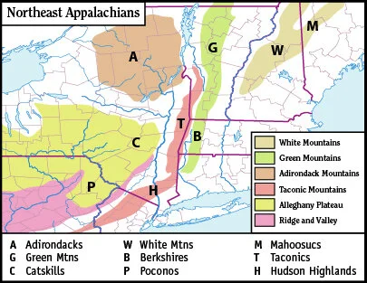
In addition to the chill, there is the threat for some springtime accumulating snow later this week across interior, higher elevation locations of the Northeast US. As a deep upper-level low slowly spins its way into the Northeast US, low pressure will form near the Mid-Atlantic coastline and then intensify as it slowly pushes to the northeast later in the week. With the colder air moving into place, accumulating snow is looking quite likely across interior, higher elevation sections of the Northeast US - perhaps all the way from the Catskills in southeastern New York State to the Green and White Mountains of northern New England. Given the strong blocking pattern in the upper atmosphere, this nor’easter is likely to only creep along the New England coastline later in the week – prolonging the misery for New Englanders right through the day on Friday.
One final note, one benefit of a colder-than-normal weather pattern across the central and eastern US in coming weeks is that the chances of severe weather in the Plains and southern US will quite likely be reduced significantly .
Meteorologist Paul Dorian
Perspecta, Inc.
perspectaweather.com


