1:30 PM (Monday) | *It could get pretty ugly this Memorial Day weekend in the Mid-Atlantic region…chilly conditions through the weekend as high pressure builds to the north and some rain*
Paul Dorian

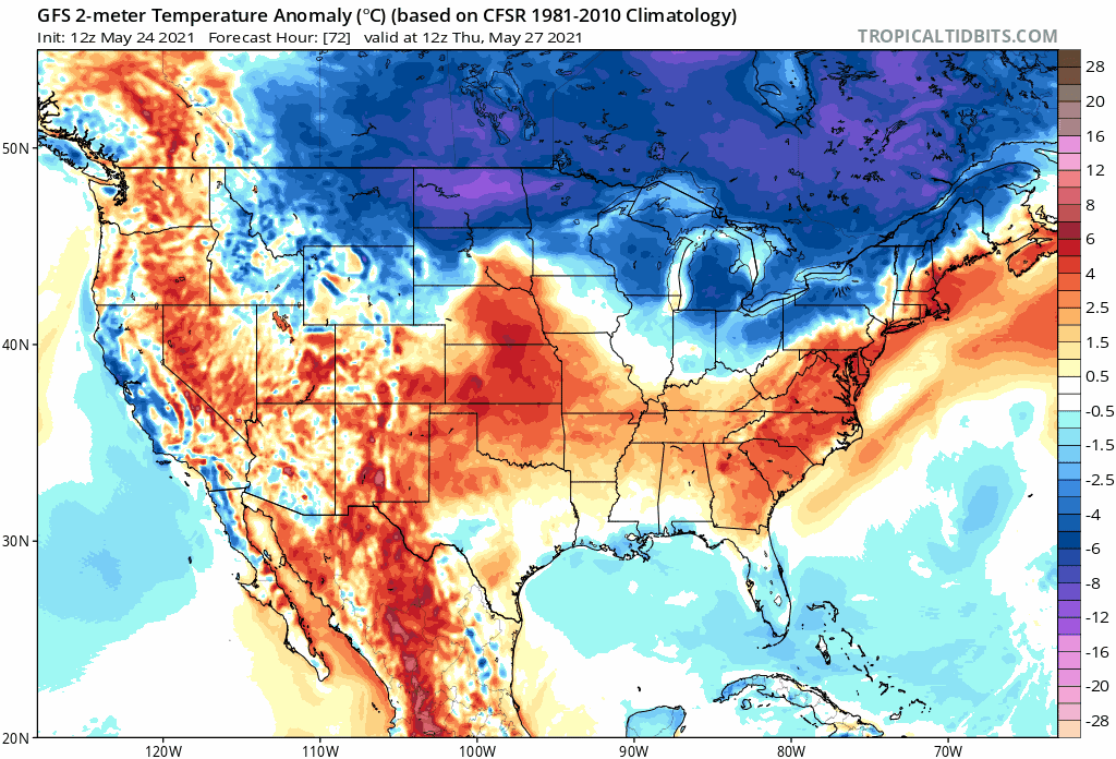
As high pressure builds to the north late this week, cooler-than normal air will push southeastward into the Mid-Atlantic/Northeast US…perhaps just in time for the Memorial Day weekend. Maps courtesy NOAA, tropicaltidbits.com
Overview
Anyone who has been a long-time resident of the Mid-Atlantic region knows that despite being dubbed the “first weekend of the summer”, Memorial Day weekend can actually turn out to be quite ugly with chilly and damp conditions. Indeed, the overall pattern appears to be setting up for just such weather conditions in the Mid-Atlantic region – at least for part of the upcoming long holiday weekend. All it takes this time of year to go from warm weather in the 70’s and 80’s to chilly weather in the 50’s and 60’s is for a strong high pressure system to build into the Northeast US or southeastern Canada. Indications are that this very well may happen this weekend likely resulting in anything but beach type weather for the Mid-Atlantic region.

High pressure will build into SE Canada later in the week at the same time low pressure heads eastward across the Midwest. The result could be some chilly and damp weather in the Mid-Atlantic region this weekend. Map courtesy NOAA, tropicaltidbits.com
Details
The past weekend featured some very warm weather in the Mid-Atlantic region with Philly reaching 92 degrees on Sunday and DC topping out at 94 degrees. A much different weather story today and it looks like for the upcoming holiday weekend. For today, temperatures will be confined to the 60’s in much of the I-95 corridor thanks to high pressure building to the north and a resultant low-level onshore flow. The same situation is likely to repeat itself this weekend with high pressure building across southeastern Canada/Northeast US and an onshore flow producing cool and occasional wet conditions in the Mid-Atlantic region.
After the cool weather of today, warmer air will begin to push northeastward on Tuesday into the Mid-Atlantic region and then an extra surge of warmth is likely to arrive on Wednesday. The surge of warmth will follow the passage of a northward-moving warm front and temperatures on Wednesday afternoon are likely to end up at or slightly above 90 degrees in the DC-to-Philly-to-NYC corridor. This surge of warmth at mid-week will be rather short-lived. A cold front will drop to the southeast by early Thursday from the Great Lakes region and high pressure will begin to build into southeastern Canada. As a result, temperatures will begin a downward trend late in the week as onshore flow forms in the Mid-Atlantic region.

Once high pressure gets established across SE Canada this time of year, it could takes a few days for its impact to diminish. This forecast map for Sunday morning, May 30th, still features high pressure in SE Canada. Map courtesy NOAA, tropicaltidbits.com
The high pressure to the north will not be the only player on the weather map as low pressure threatens to slide eastward into the Mid-Atlantic region. This system could produce some beneficial rainfall at the end of the week and the beginning of the weekend at the same time low-level onshore flow keeps it quite cool (i.e., potentially in the 50’s and 60’s for highs rather than the desired 70’s and 80’s). Any rainfall would be welcome in most quarters as it has been a rather dry stretch in the DC-to-Philly-to-NYC corridor during the past couple of weeks (the DC metro region could actually get some needed rain later today).
Once high pressure becomes established this time of year across southeastern Canada, it often takes a bit of time to dislodge the cool air mass that usually develops in the Mid-Atlantic region. While the Friday/Saturday rain event may indeed be followed by improving conditions on Sunday and Monday (i.e., perhaps some sunshine), it is quite likely that it’ll stay on the chilly side for this time of year with strong high pressure hanging over southeastern Canada…not the most enjoyable weather conditions to begin the summer season.
Meteorologist Paul Dorian
Peraton
peratonweather.com
Follow us on Facebook, Twitter, YouTube
Video discussion: