1:00 PM (Tuesday) | *Not exactly beach weather this holiday weekend in the Mid-Atlantic region and it could get started with some chilly (but beneficial) rainfall*
Paul Dorian

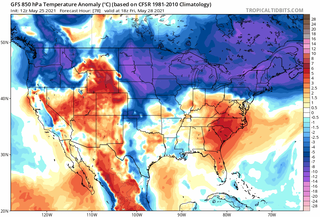
Much of the holiday weekend will feature below-normal temperatures across the eastern half of the nation as depicted here in these 850 mb temperature anomaly forecast maps that extend from Friday afternoon-to-Monday afternoon. Maps courtesy NOAA, tropicaltidbits.com
Overview
Last weekend was very warm in the Mid-Atlantic region with highs in many places like Philly and Washington, D.C. above the 90 degree mark on both days…this weekend will be quite a different story. The Memorial Day weekend has been unofficially called the beginning of the summer season, but it will be anything but beach weather this time around in the Mid-Atlantic region. Anyone who has been a long-time resident of this area knows that an ocean flow this time of year can result in highs in the 50’s and 60’s rather than the more desired 70’s and 80’s. In addition to the cooler-than-normal conditions expected this weekend, it looks like it will get started with a chilly, but beneficial rainfall from Friday into Saturday.

Temperatures will surge on Wednesday ahead of a cold frontal system and there can be some strong-to-severe thunderstorm activity in the afternoon and evening across interior sections of the Mid-Atlantic and Northeast US. Map courtesy NOAA/SPC
Details
Temperatures remain in a struggle today to escape the 60’s given persistent cloud cover, but there will be a warm air surge on Wednesday following the passage of a northward-moving warm front. In fact, temperatures tomorrow afternoon could spike to 90+ degrees in the I-95 corridor and there will be the chance for afternoon and evening showers and thunderstorms. Some of the storms later tomorrow can reach strong-to-severe levels with potential damaging wind gusts; especially, across interior sections of the Mid-Atlantic region.

Low pressure will travel from the Midwest on Friday to the Mid-Atlantic coastal waters on Saturday and it is likely to result in a decent and beneficial rainfall for the Mid-Atlantic region. Map courtesy NOAA/SPC
It’ll remain pretty warm on Thursday as well, but then building high pressure into southeastern Canada will begin a downtrend in temperatures at week’s end. At the same time we start to feel the effects of cooler ocean air, low pressure will trek from the Midwest on Friday to the Mid-Atlantic coastal waters on Saturday. This system combined with moist ocean flow may actually produce the first decent and widespread rain event for the Mid-Atlantic region in a few weeks. The last two weeks have been especially dry in parts of the I-95 corridor where pollen has turned many outdoor objects quite green in recent days. The rain is likely to run from later Friday into Saturday morning/mid-day and most spots should receive more than half an inch and potentially as much as an inch and a half or two inches along coastal sections.
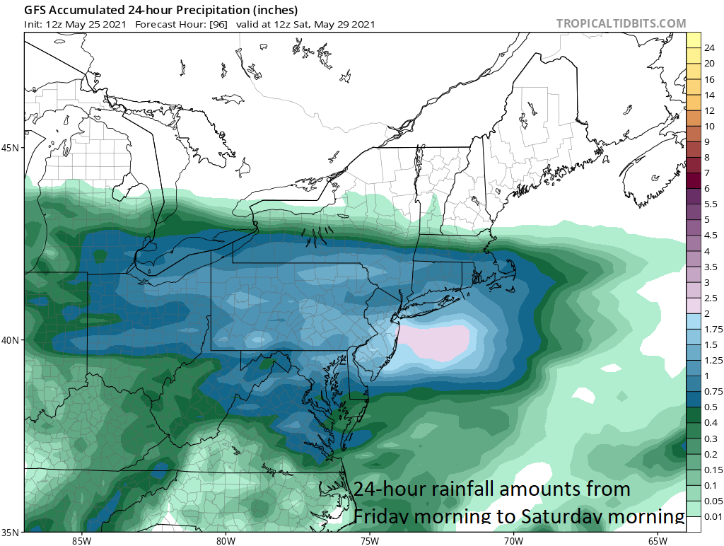
Rainfall amounts of at least half an inch are likely throughout the Mid-Atlantic region in the time period from later Friday to mid-day Saturday and some coastal sections could see upwards of two inches. Map courtesy NOAA
With high pressure hanging around southeastern Canada through much of the weekend, temperatures should remain well below-normal in the Mid-Atlantic from Friday through Sunday and then slightly below-normal on Monday, Memorial Day. While the steadiest rain is likely to occur with the Friday-to-Saturday system, upper-level instability could result in isolated-to-scattered showers on Sunday to go along with the cool temperatures and a likely mix of clouds and sun. Perhaps the best day of the holiday weekend will turn out to be Monday, Memorial Day, as increased sunshine should boost temperatures somewhat compared to the weekend’s chilly conditions.
Meteorologist Paul Dorian
Peraton
peratonweather.com
Follow us on Facebook, Twitter, YouTube
Video discussion: