1:30 PM (Wednesday) | *Strong-to-severe thunderstorm threat later today/early tonight…beneficial soaking rain event to begin a very chilly Memorial Day weekend in the Mid-Atlantic region*
Paul Dorian

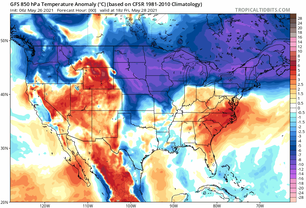
Much of the eastern half of the nation will experience a chilly Memorial Day weekend. 850 mb temperature anomaly forecast maps (06Z GFS) extend here from Friday-to-Monday (courtesy NOAA, tropicaltidbits.com)
Overview
Temperatures have surged today in the Mid-Atlantic region ahead of an approaching frontal system and humidity levels have climbed dramatically as well. The combination of very warm and humid air, a strong surface front, and vigorous energy aloft will lead to scattered strong-to-severe thunderstorms later today and early tonight. Any strong-to-severe storm that forms can potentially produce damaging wind gusts and large hail. After another warm day on Thursday (but less humid), temperatures will begin a downward trend on Friday as high pressure builds to our north into southeastern Canada. Low pressure will trek from the Midwest on Friday to the Mid-Atlantic coastal waters by later Saturday producing a beneficial soaking rain event in the Mid-Atlantic region as a very chilly Memorial Day weekend gets underway.

There will be two areas of storms to closely monitor later today/early tonight in the Mid-Atlantic region. The initial band will be associated with a pre-frontal trough and the second batch will come along or just ahead of the actual surface cold front. Maps courtesy NOAA, tropicaltidbits.com
Details
Temperatures today have soared into the 80’s in the DC-to-Philly-to-NYC corridor and dew points have climbed into the upper 60’s/lower 70’s - making it feel rather summer-like out there. Meanwhile, a cold front is pushing to the southeast across the Great Lakes region and it will combine with upper-level support to generate strong-to-severe thunderstorms in the Mid-Atlantic region later today and early tonight. Not everyone will get hit by these storms, but any given locale can have heavy rain, damaging wind gusts, and even large hail in this increasingly unstable atmosphere. The timetable for the storm threat will be rather extended from about 3PM to 10PM as there are likely to be a couple of separate bands to closely monitor. The first set of storms will be associated with a pre-frontal trough and the second (and later) batch of storms will take place along and just ahead of the actual surface cold frontal system.
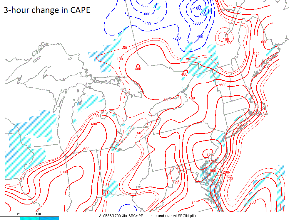
One parameter that is a measure of atmospheric stability is known as the Convective Available Potential Energy (CAPE) and an increasing amount over the past 3 hours - as seen here over SE PA - is a sign of a destabilizing atmosphere and the rising potential of strong-to-severe thunderstorm activity. Map courtesy NOAA
After a warm day on Thursday, the tide will turn quite dramatically over the next couple of days with respect to temperatures in the Mid-Atlantic region as high pressure begins to build into southeastern Canada. At the same time, low pressure will strengthen over the Midwest and trek across the Mid-Atlantic region reaching the coastal waters by later Saturday. As a result, a beneficial soaking (and chilly) rain event is quite likely in the Mid-Atlantic region from later Friday into Saturday. This chilly rain is not good timing in terms of the holiday weekend, but it should certainly help out with all vegetation and help clean away some of the recent buildup of pollen (if today’s rain doesn’t do the job). This will be the first widespread soaking rain event in weeks for some areas of the Mid-Atlantic region.

06Z Euro forecast map for early Saturday suggests soaking rain will fall in the Mid-Atlantic region - the first widespread soaking rain event in weeks and it will be chilly. Map courtesy WSI, Inc, ECMWF
Once the low pressure system reaches the coastal waters off of New Jersey on Saturday, it will tend to slow down as upper-level support slowly spins over the Northeast US. As a result, it’ll certainly stay well below-normal on Sunday in terms of temperatures and an unsettled atmosphere is likely to produce lots of clouds and maybe a few lingering showers. Improvement is likely on Monday, Memorial Day, with an increased amount of sunshine and temperatures should respond by climbing back into the 70’s for highs after a very chilly Saturday and Sunday.
Meteorologist Paul Dorian
Peraton
peratonweather.com
Follow us on Facebook, Twitter, YouTube
Video discussion: