2:00 PM | *It may not be the best timing, but a beneficial soaking rain event will begin what will turn out to be a very chilly Memorial Day weekend…best weather day quite likely to be Monday*
Paul Dorian

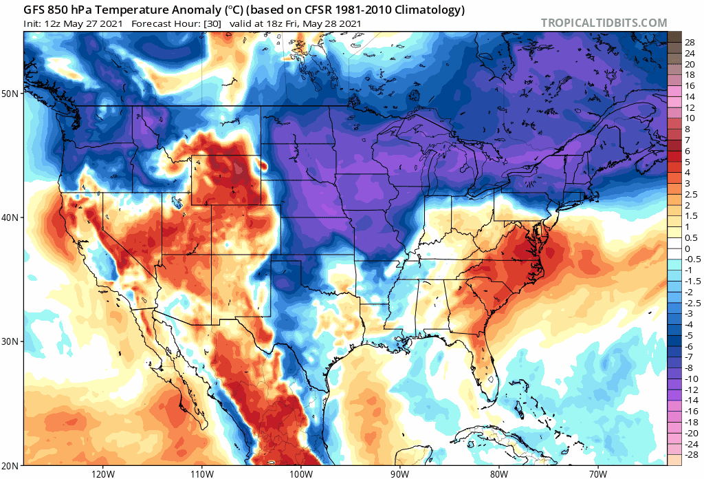
Temperatures could drop to as much as twenty degrees below-normal during the upcoming holiday weekend across much of the eastern half of the nation. Forecast maps of 850 mb temperature anomalies from Friday afternoon-to-Monday afternoon courtesy NOAA, tropicaltidbits.com
Overview
Temperatures remain quite warm today across the Mid-Atlantic region, but dew points have come down noticeably since last night’s frontal passage. Big changes are coming by the weekend, however, with respect to temperatures that could drop to as much as twenty degrees below-normal for the late stages of the month of May. Low pressure will move from the Midwest on Friday to the coastal waters of the Mid-Atlantic by later Saturday and it’ll combine with a building high pressure system across southeastern Canada to generate the first widespread and soaking rain event in weeks for the Mid-Atlantic region. It’ll remain very cool for this time of year on Sunday and unsettled with lingering showers possible. The best weather day of the long holiday weekend is quite likely going to be Monday with increasing amounts of sunshine and noticeably milder conditions.

Low pressure will combine with high pressure to the north to generate a chilly, soaking rain event for the Mid-Atlantic at the beginning of a very cool Memorial Day weekend. Map courtesy NOAA, tropicaltidbits.com
Details
Temperatures have climbed to near 80 degrees today in the I-95 corridor, but it’ll turn dramatically cooler for the upcoming holiday weekend as high pressure begins to build into southeastern Canada. At the same time, low pressure will strengthen over the Midwest on Friday and trek across the Mid-Atlantic region reaching the coastal waters by later Saturday. As a result, a beneficial soaking and chilly rain event is coming to the Mid-Atlantic region from later tomorrow into Saturday. This chilly, rain is not good timing in terms of the holiday weekend, but it will certainly help out with vegetation and clean up some of the pollen buildup assuming it wasn’t washed away with last night’s storms.

An upper-level trough will remain overhead of the NE US/Mid-Atlantic region through the weekend assuring unsettled and chilly conditions on Sunday as well as Saturday…Monday, Memorial Day, is looking like the best weather day of the long weekend. Map courtesy NOAA, tropicaltidbits.com
Once the low pressure system reaches the coastal waters off of New Jersey on Saturday, it will tend to slow down as upper-level support slowly meanders across the Northeast US. As a result, it’ll certainly stay much colder-than-normal on Sunday in the Mid-Atlantic region and an unsettled atmosphere is likely to produce plenty of clouds and maybe even a few lingering showers. Improvement is likely on Monday as there should be an increased amount of sunshine and temperatures should respond by climbing back towards the 70 degree mark after the unusually chilly days on Saturday and Sunday.
Meteorologist Paul Dorian
Peraton
peratonweather.com
Follow us on Facebook, Twitter, YouTube