
11:50 AM (Thursday) | *Downpours/strong-to-severe thunderstorms on the table for later today/tonight…hot, increasingly humid weather for Sunday-to-Wednesday*
Paul Dorian

Downpours and strong-to-severe thunderstorms are possible later today/tonight in the I-95 corridor. Map courtesy NOAA, tropicaltidbits.com
Overview
The combination of a moist air mass, surface frontal systems, and a slow-moving upper-level trough is bringing more rainfall to the Mid-Atlantic region and there can be downpours later in the day and again tonight which could result in some localized flash flooding. In addition, there is the potential for strong-to-severe thunderstorm activity ahead of an advancing cold frontal system. The upper-level trough will still be to the west of the I-95 corridor on Friday leading to an unsettled day and the possibility of additional showers and thunderstorms. High pressure builds across the eastern states this weekend and a classic summertime “Bermuda high” setup is likely to result in hot, increasingly humid and summer-like weather for the period from Sunday-to-Wednesday with daily high temperatures at or above the 90 degree mark in the I-95 corridor.
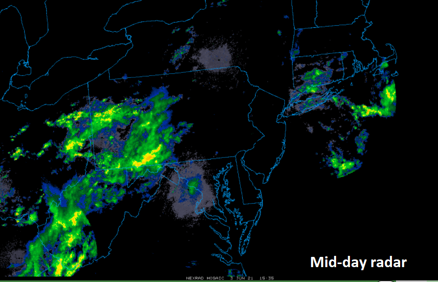
Mid-day radar features showers and embedded thunderstorms extending across West Virginia and western PA. This batch of rain will likely advance into the I-95 corridor in the 3-9pm time period. Map courtesy College of DuPage, NOAA
Details
A warm front pushed northward along the east coast early today and now a cold front is approaching from the northwest. At the same time, a slow-moving (positively-tilted) upper-level trough of low pressure is edging our way and it’ll play an important role in the threat of downpours later today and tonight and also raising the prospects for strong-to-severe thunderstorm activity.

An upper-level trough to our west on Thursday is combining with two surface frontal systems and a moist air mass to produce some heavy shower activity and possible late day/evening strong-to-severe thunderstorms in the I-95 corridor. Map courtesy NOAA, tropicaltidbits.com
The rain has slackened off at mid-day following the passage of a warm frontal system, but showers and embedded storms are expanding in coverage to our west from West Virginia to western Pennsylvania. This next batch of rain is likely to impact the I-95 corridor in the period from around 3-9pm and there is likely to be some heavy rainfall which can lead to localized flash flooding. Any thunderstorm that forms later in the day and early tonight can reach strong-to-severe levels with the potential of damaging wind gusts and hail.

A stretch of hot and humid weather is likely for the Mid-Atlantic region from Sunday through Wednesday of next week as high pressure shifts to the western Atlantic. Map courtesy ECMWF, tropicaltidbits.com
On Friday, the upper-level trough will swing across the east coast and the cold front will tend to fall apart as it clears the eastern seaboard. There can be some residual shower and thunderstorm activity on Friday and the rain can still come down hard given the high humidity levels. High pressure ridging will build into the eastern states on Saturday and then shift off the east coast by Sunday. In this unfolding classic “Bermuda high” position over the western Atlantic Ocean, very warm and increasingly humid air will flow northeastward into the Mid-Atlantic region for the Sunday-to-Wednesday time period. As a result, high temperatures for the first half of next week in the DC-to-Philly-to-NYC corridor are likely to be at or above the 90 degree mark - a true taste of summer and a far cry from the unusual chill of last weekend.
Meteorologist Paul Dorian
Peraton
peratonweather.com
Follow us on Facebook, Twitter, YouTube
Video discussion: