2:30 PM | ***Complex of severe thunderstorms tonight Upper Midwest…severe weather threat in the Mid-Atlantic on Thursday…very comfortable conditions follow for the end of July/beginning of August***
Paul Dorian

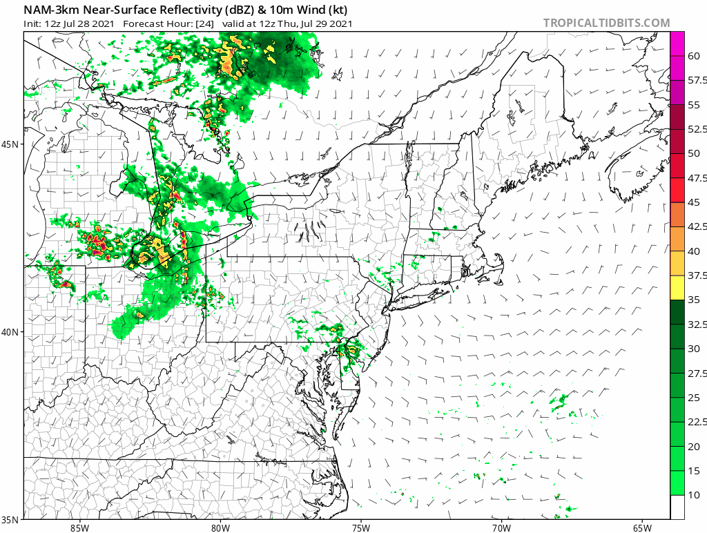
High-resolution NAM computer forecast model predicts of lot of thunderstorm activity in the Mid-Atlantic region on Thursday and it could include severe weather. Maps courtesy NOAA, tropicaltidbits.com
Overview
The overall weather pattern is evolving to one that will bring very comfortable air to the Mid-Atlantic region as we end the month of July and begin the month of August, but it may a rough time getting there with severe weather a threat on Thursday. A complex of severe thunderstorms will blast through Wisconsin in the overnight hours from northwest-to-southeast and this line will play a key role on Thursday in the Mid-Atlantic region. There is the potential later tomorrow for severe weather in the Mid-Atlantic region to include all the parameters from hail-to-heavy rain-to-tornadoes. Once the cold frontal system passes through the region, quite comfortable air will push in on Friday riding along on stiff northwest winds and the comfortable weather pattern will last through much of next week as well – the first full week of August.

A line of severe thunderstorms will blast through Wisconsin later tonight from northwest-to-southeast. This system will play a key role in the severe weather threat on Thursday across the eastern Ohio Valley and Mid-Atlantic region. Map courtesy NOAA, tropicaltidbits.com
Severe weather threat
Severe thunderstorms are likely later tonight across Wisconsin and it may turn out to be associated with a long-lasting line of severe storms often referred to as a derecho in the weather community. This system will push from the northwest-to-southwest and its remains will play a key role in the potential for severe weather on Thursday in the eastern Ohio Valley and the Mid-Atlantic. In addition to the remains of this complex of thunderstorms, other ingredients on Thursday will include an approaching mid-level jet, vorticity max, and strong wind shear. If these ingredients come together at the right time, all severe weather parameters will be on the table including hail, torrential rain and even tornadoes. One complicating factor in the forecast is the possibility for some early morning shower and thunderstorm activity in the Mid-Atlantic region. If this does occur and is a little longer-lasting than expected, it could diminish the chances for severe weather later in the day by limiting daytime heating; however, I wouldn’t count on that…stay tuned, check back in the morning.

Cooler-than-normal temperatures are likely in much of the eastern US as we end the month of July and begin the month of August. Maps courtesy NOAA, tropicaltidbits.com
Very comfortable temperatures
How do the 50’s sound for overnight lows as we begin the upcoming weekend and on the last day of July? So far in the month of July, temperatures have averaged slightly below-normal in Central Park (New York City) at -1.2 degrees and nearly normal in Philly (+0.4 degrees) and Washington, D.C. (-0.1 degrees). The last couple of days of July is likely to feature below-normal temperatures following the passage of a strong cold front later tomorrow and much of next week looks cooler-than-normal as well in the Mid-Atlantic. In fact, the first full week of August could feature below-normal temperatures in a large portion of the eastern US thanks to an intensifying upper-level low.
In addition to the potential for cooler-than-normal weather next week, the eastern US may have to deal with plenty of moisture. In fact, there are signs that it could turn into quite an extended period of wet weather conditions from the Gulf coast to the east coast which could include surface low pressure near the eastern seaboard by the middle of next week. In other words, there is the chance for some relatively cool and damp weather in the eastern states next week – pretty unusual for the first week of August.
Meteorologist Paul Dorian
Peraton
peratonweather.com
Follow us on Facebook, Twitter, YouTube
Video discussion: