1:15 PM | *Tropical Storm Elsa moving through the Carolinas on the way to the Mid-Atlantic/NE US…heavy rain/possible strong-to-severe thunderstorms…highest wind gusts along coastal sections*
Paul Dorian

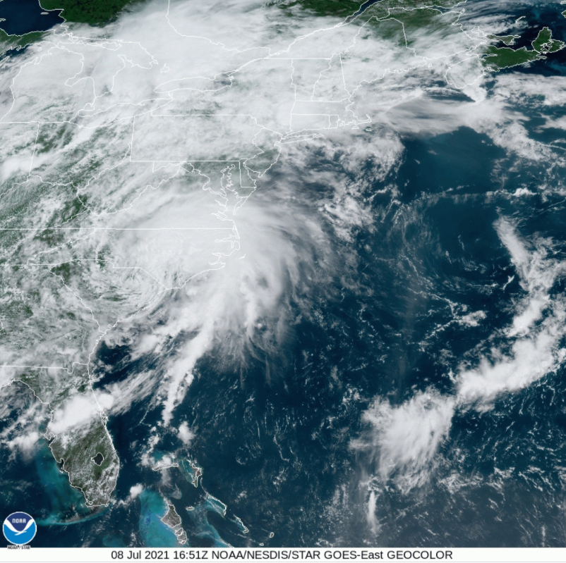
Tropical Storm Elsa is pushing through the Carolinas and on the way to the Mid-Atlantic/NE US. Image courtesy NOAA/GOES-East
Overview
“Elsa” has maintained its status at mid-day as a tropical storm while pushing northeastward over the Carolinas and on the way to the Mid-Atlantic/Northeast US. It should reach a position over the Delmarva Peninsula by later tonight and then move to over southern New Jersey by the wee hours of Friday morning. This storm will bring heavy rainfall to the Mid-Atlantic region along with possible strong-to-severe thunderstorms; especially, along coastal sections where isolated tornadoes are possible. Highest wind gusts in the overnight hours will be along coastal sections from the Delmarva Peninsula-to-New Jersey-to-Long Island.

Elsa began as a tropical wave last week over the eastern Atlantic Ocean and crossed the Caribbean Sea this past weekend on its way to the eastern Gulf of Mexico. Map courtesy NOAA, Wikipedia
Details
Elsa developed last week over the eastern Atlantic Ocean despite some cooler-than-normal sea surface temperatures and then pushed into the Caribbean Sea early this past weekend. The warm waters of the central and western Caribbean Sea allowed it to intensify as it headed towards the island of Cuba and ultimately reaching near the Florida Keys by early Tuesday. Elsa then made landfall on Wednesday morning in the northern Gulf coastal region of Florida, crossed the northern part of the state, and reached southern Georgia in the overnight hours. While Elsa reached hurricane status briefly over the far eastern Gulf of Mexico, it made landfall yesterday morning as a strong tropical storm. Now Elsa is pushing northeastward over the Carolinas and has begun to accelerate as tropical systems often do when they reach higher latitudes.

The highest rainfall amounts are likely along and to the south and east of Route I-95 during the next 48 hours with a sharp drop off to the N and W. Map courtesy Pivotal Weather, NOAA
Heavy rain and possible strong-to-severe thunderstorms will push into the Mid-Atlantic region later this afternoon and continue into early Friday morning. There is the chance for as much as 2-4 inches of rain along and east of Route 95 in the DC-to-Philly-to-NYC corridor with isolated higher amounts on the table…watch out for localized flooding. The rain amounts to the N and W of I-95 will likely drop off rather sharply and end up in the 1-2 inch range by early tomorrow. Thunderstorms that form with this storm can reach strong-to-severe levels and isolated tornadoes are always a threat to the right of the track of a tropical system that is moving to the north or northeast. That would put the highest chance for isolated tornadoes from Elsa to be along coastal sections of the Mid-Atlantic…same region likely with the highest wind gusts.
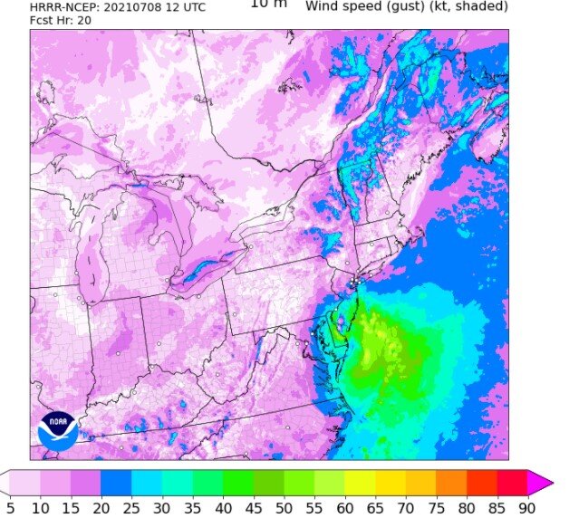
High-resolution model (12Z HRRR) indicates gusts can reach 60 mph at the Jersey Shore. Map courtesy NOAA
The highest wind gusts associated with Elsa – perhaps at 50+ mph - are likely to take place later tonight into early Friday morning along the coastal sections of the Delmarva Peninsula-to-New Jersey-to-Long Island. Elsa will reach the eastern part of New England later tomorrow and then the Nova Scotia region of Canada by early this weekend. After that, the remains of Elsa could very well head to Greenland where it actually may be cold enough for some frozen precipitation…the cold never did bother her anyway.
Meteorologist Paul Dorian
Peraton
peratonweather.com
Follow us on Facebook, Twitter, YouTube
Video discussion: