11:50 AM | ***Showers/storms from remnants of “Fred”…any storm can be severe with isolated tornadoes a threat…TS “Henri” needs to be closely monitored by coastal residents of Northeast US***
Paul Dorian

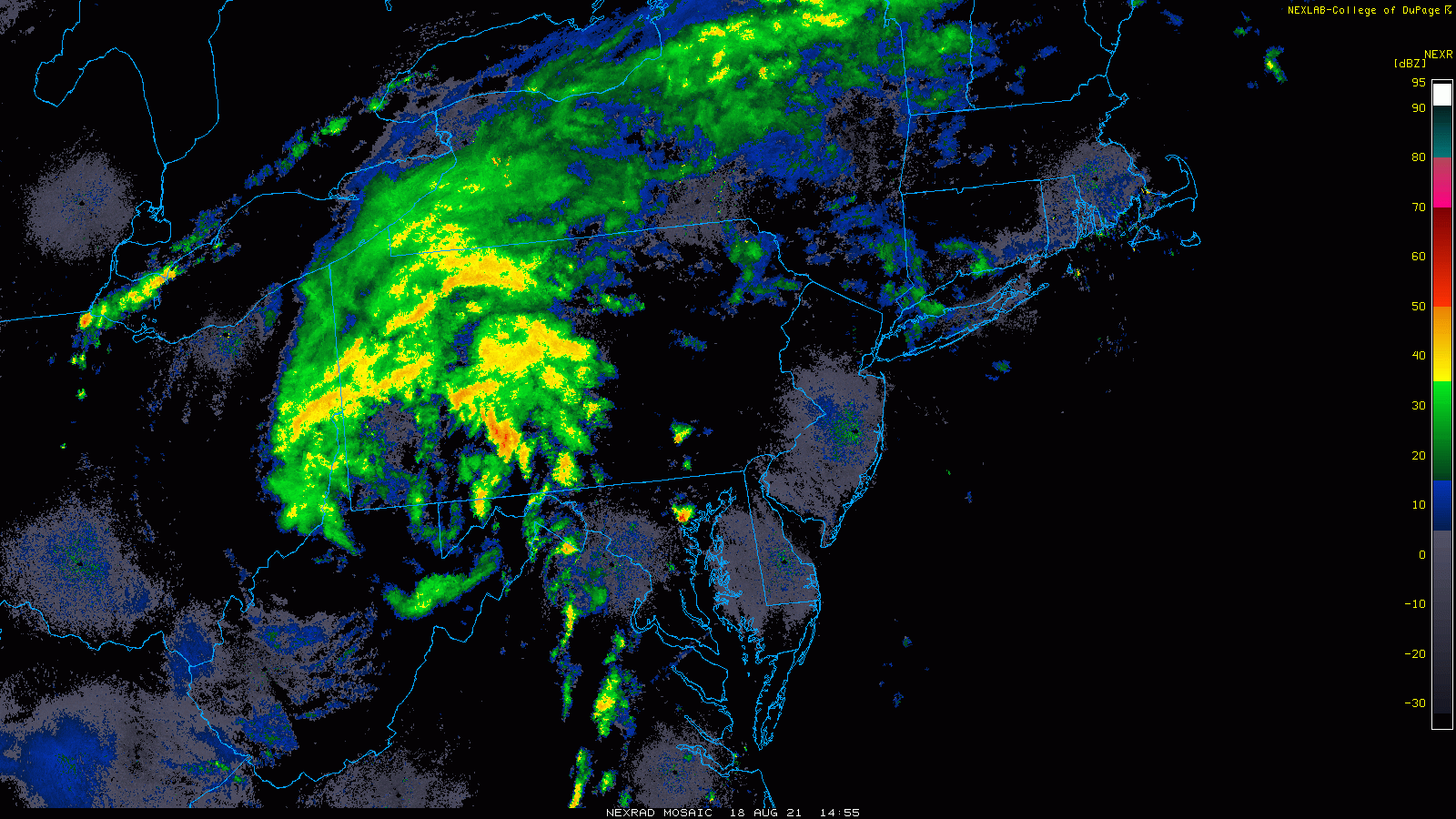
The remnants of TS Fred are resulting in showers/storms for the Mid-Atlantic region and some of the storms can become severe with isolated tornadoes a threat. Images courtesy College of DuPage, NOAA
Overview
The remnants of Tropical Storm “Fred” continue to push to the northeast today and are now centered over the southwestern part of Pennsylvania. Its tropical moisture field has spread throughout the Mid-Atlantic region and is enhancing the chance for downpours later today and tonight also the chance for severe thunderstorm activity which may include isolated tornadoes.
Meanwhile, Tropical Storm “Henri” continues to spin out over the Atlantic Ocean and is likely to intensify into hurricane status in the near-term. There are some “red flags” in the developing weather pattern that suggest “Henri” should be very closely monitored in coming days; especially, for coastal residents of the Northeast US.

NOAA’s Storm Prediction Center has the Mid-Atlantic region in a “slight” risk area for severe weather. Thunderstorms in the Mid-Atlantic region can reach severe levels later today and tonight with isolated tornados a threat on the eastern side of the northward-moving tropical system.
Mid-Atlantic heavy rain and isolated tornado threat
A tropical air mass associated with the remains of Tropical Storm “Fred” has spread throughout the Mid-Atlantic region with dew points well up in the 70’s. The heaviest and steadiest rainfall associated with the remains of TS “Fred” will generally stay well to the north and west of Route I-95 during the next several hours; however, any shower that does develop in the immediate I-95 corridor can produce significant rainfall in a short period of time. In addition, any thunderstorm that forms in the DC-to-Philly-to-NYC corridor can reach severe status and - as is customary with tropical systems in higher latitudes - the threat of isolated tornadoes will exist on the eastern side of the storm track. This will put the threat zone for isolated tornadoes right in the immediate I-95 corridor region for later today and tonight. During the nighttime hours, the heavy rain threat will tend to shift to the east; especially, across Pennsylvania where torrential rain can fall all the way to the Delaware River. The remains of “Fred” will be centered over central New York State by tomorrow morning and the threat for steadier rainfall will diminish in the DC-to-Philly-to-NYC corridor. However, an unsettled atmosphere will continue to result in some isolated-to-scattered shower and thunderstorm activity from later tomorrow through the day on Friday.
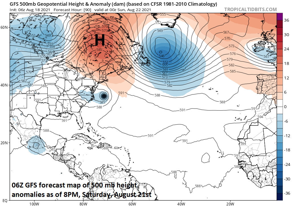
Strong high pressure ridging in coming days over the southeastern part of Canada may allow Tropical Storm Henri to come awfully close to the coastline of the Northeast US…this system needs to be closely monitored; especially, in coastal sections from the Mid-Atlantic to northern New England. Map courtesy tropicaltidbits.com, NOAA
“Red flags” concerning Tropical Storm “Henri”
Meanwhile, Tropical Storm “Henri” continues to churn slowly out over the western Atlantic Ocean and increasingly favorable environmental conditions should allow for it to attain hurricane status in the near term. It is currently sitting nearly underneath a strong high pressure ridge in the upper part of the atmosphere and the overall weak wind field is resulting in a rather slow-moving system at this time (westerly at only 8 mph). Later in the week, the strong high pressure ridging aloft will tend to retreat over the western Atlantic and become more concentrated over the southeastern part of Canada. This re-positioning may allow for a movement of “Henri” to the northwest this weekend and towards the Northeast US coastline.

One computer forecast model that has favored a solution of “Henri” having a possible impact on the Northeast US coastline is NOAA’s GFS. Today’s 12Z version depicts a track of “Henri” right to Long Island or southern New England by the end of the weekend. Map courtesy weathermodels.com (Dr. Ryan Maue, Twitter), NOAA
Indeed, a teleconnection index known as the North Atlantic Oscillation (NAO) – often used in wintertime analysis - stays in “negative” territory in coming days and this trend supports the idea of a “blocking” type of upper air pattern that could result in a movement of “Henri” to the northwest by later this weekend or early next week - and potentially towards the Northeast US coastline. The bottom line is that all coastal residents from the Mid-Atlantic region to northern New England should closely monitor this tropical system in coming days.

A teleconnection index known as the North Atlantic Oscillation stays in “negative” territory in coming days which supports the idea of strong high pressure ridging over southeastern Canada which could allow “Henri” to push northwestward this weekend. Map courtesy NOAA
The latest on what is now Hurricane “Grace”
Finally, the same high pressure system that is sitting nearly on top of Tropical Storm “Henri” over the western Atlantic Ocean continues to help steer “Grace” – now of category 1 hurricane status - to the west and right towards the Yucatan Peninsula region of Mexico. After an encounter with the land mass of the Yucatan on Thursday/Thursday night, “Grace” is likely to continue on a general westward track and head to the northeast coastline of Mexico.
Meteorologist Paul Dorian
Peraton
peratonweather.com
Follow us on Facebook, Twitter, YouTube
Video discussion: