
10:45 AM (Tuesday) | **Significant rainfall on the way for the Mid-Atlantic as a cold front will grind its way through the region...strong-to-severe thunderstorms on the table as well**
Paul Dorian
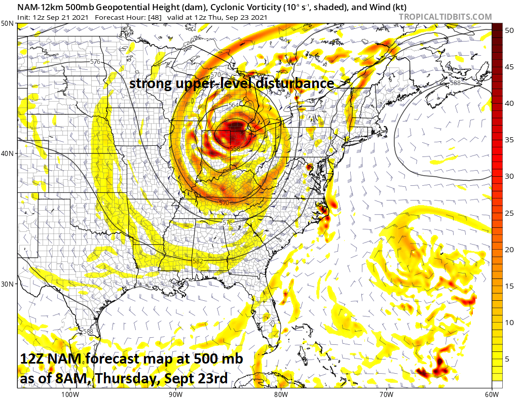
One ingredient that will increase chances for significant rainfall in the Mid-Atlantic region will be a strong upper-level disturbance that will grind to a halt over the Great Lakes/Ohio Valley. The slow movement of the surface cold front and upper-level disturbance will lead to an extended threat of rain in the Mid-Atlantic from early Wednesday to late Thursday. Map courtesy NOAA, tropicaltidbits.com
Overview
There is a good chance for significant rainfall later this week in the Mid-Atlantic region as a cold front inches its way across the area. This cold front will have support aloft from a strong disturbance that will center itself over the Great Lakes/Ohio Valley and there will be plenty of low-level moisture within the broad south-to-southeast flow of air that forms on its front side. Showers are likely to first develop on Wednesday across western sections of the Mid-Atlantic region and then gradually spread eastward on Wednesday night and Thursday. There is also likely to be a threat for strong-to-severe thunderstorms on Thursday and Thursday night to go along with the heavy rain threat.

One ingredient that will increase chances for significant rainfall in the Mid-Atlantic region will be an influx of high-levels of moisture as a broad south-to-southeast flow of air develops ahead of the slow-moving cold front. Map courtesy NOAA, tropicaltidbits.com
Details
There was a heavy rain event in the Mid-Atlantic region earlier this month associated with the remains of Hurricane “Ida” and we are setting up for more significant rainfall later this week. In fact, there is the chance for 2+ inches of rain along and especially to the west of the DC-to-Philly-to-NYC corridor from Wednesday into late Thursday night as a strong cold front grinds its way through the area. The slow-moving cold front will have plenty of moisture to work as it slides into the Mid-Atlantic region given the expectation of broad south-to-southeast flow of air that will form on its front side. In addition, the surface frontal system will be supported by strong upper-level energy that will tend to sit and spin for awhile over the Great Lakes/Ohio Valley and the result will likely be an extended period of rainfall in the eastern states. The front should be oriented north-to-south through New Jersey by the time we get to early Friday morning with rain possibly lingering along and east of I-95 and then it should grudgingly push offshore by later in the day.

This upcoming weather event could result in more than 2 inches of rainfall for the Mid-Atlantic region from tomorrow into late Thursday. Given the already well-saturated grounds, any significant rainfall could raise the chance for flash flooding. Map courtesy NOAA
As a result of the heavy rain event earlier this month, the grounds are still pretty well saturated in the Mid-Atlantic region and we’ll have to watch out for the possibility of flash flooding. Temperatures will likely be noticeably cooler on Thursday in the I-95 corridor and then confined to the 70’s this weekend in the wake of the frontal passage. With the front sitting not too far off the coast, we’ll have to be on alert for another wave of low pressure to form along the boundary zone and which could bring additional rain to the region early this weekend. Another upper-level trough is likely to form in the eastern states later next week and this can result in some cooler-than-normal weather.

This unfolding weather event will likely include the possibility of strong-to-severe thunderstorm activity in the Mid-Atlantic region on Thursday and Thursday night. Map courtesy NOAA/Storm Prediction Center
Meteorologist Paul Dorian
Peraton
peratonweather.com
Follow us on Facebook, Twitter, YouTube
Video discussion: