10:55 AM | ***Next snow threat for the Mid-Atlantic comes on Thursday night/early Friday…impressive cold blasts on the horizon...one to accompany the late week system and another early next week***
Paul Dorian

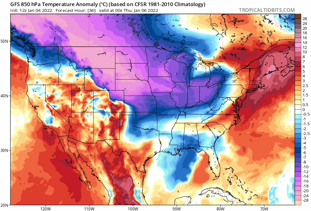
A late week snow threat in the Mid-Atlantic/NE US may very well be accompanied by some impressively cold air and another cold blast is destined to arrive early next week. Maps courtesy NOAA, tropicaltidbits.com extend from Wednesday night into next Tuesday
Overview
The month of January got off to a very mild start in the Mid-Atlantic region this past weekend, but a strong cold frontal passage on Sunday night changed that around quite dramatically by Monday. In addition to the influx of the cold air mass, significant snow fell across parts of the region from the DC metro area to the Delmarva Peninsula to the Jersey Shore, but there was a sharp cutoff on the northern fringes with little or no snow at all in the Philly and NYC metro regions. The next threat of accumulating snow for the Mid-Atlantic region comes on Thursday night and early Friday as low pressure pushes to near the Mid-Atlantic coastline. Perhaps a bigger story, however, is the cold that appears to be on the way. An impressive cold shot will likely accompany and follow this late week system into the Mid-Atlantic region and then another cold blast is destined to arrive early next week. The blast early next week could turn out be a doozy with “single-digit” type cold…get ready for those heating bills.
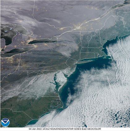
A morning satellite image from GOES-East reveals snow cover extending from southwestern Virginia to central New Jersey with a sharp cutoff to the north. Image courtesy NOAA/NESDIS/Geocolor
Details
High pressure has pushed into the Mid-Atlantic region today and it’ll result in plenty of sunshine, light winds, and cold conditions. The high pressure moves off the east coast on Wednesday and this will allow for milder to push in on increasingly strong SW winds out ahead of the next cold frontal system. That front will usher in a pretty impressive-looking cold air mass for the late week time period – just in time for the next low pressure system as it likely impacts the Mid-Atlantic region on Thursday night and early Friday.

An upper-level disturbance will ravel rather quickly across the country over the next couple of days and it should help to generate low pressure near the Mid-Atlantic coastline later Thursday night/early Friday. Map courtesy NOAA, tropicaltidbits.com
An upper-level disturbance that is currently located over the northeastern Pacific Ocean will cross the nation rather quickly over the next couple of days and arrive in the eastern states on Thursday night. This upper-level system will be a key to the snow threat on Thursday night and early Friday as it will help to spawn surface low pressure near the Mid-Atlantic coastline that will then intensify as it moves to the northeast out over the open waters of the western Atlantic Ocean. The exact track and rate of intensification of this low pressure system will play crucial roles in determining how much snow can accumulate in the Mid-Atlantic region on Thursday night and Friday. We’ll have a better idea on these factors over the 24 hours or so, but for now, my initial expectations are for a moderate snow event only in the DC-to-Philly-to-NYC corridor - perhaps on the order of 3-6 inches - and it may very well turn out to be quite a cold storm with high snow-to-liquid ratios (i.e., dry, powdery snow). A track of the low pressure system farther to the south and east than currently projected could lower these amounts in the immediate I-95 corridor.
A quick, but brief warm up is likely later in the weekend, but there are signs for another cold blast early next week that could result in “single-digit kind of cold” for at least parts of the I-95 corridor in the Mid-Atlantic/NE US. This very impressive-looking cold shot for early next week could very well push into the Mid-Atlantic region with a more widespread snow pack compared to what we have today.
The mild start to the month of January in the Mid-Atlantic region may soon seem like a very distant memory.
Meteorologist Paul Dorian
Arcfield
arcfieldweather.com
Follow us on Facebook, Twitter, YouTube
Video discussion: