
11:20 AM | ***Accumulating snow tomorrow night into early Friday…cold blasts to continue into next week***
Paul Dorian
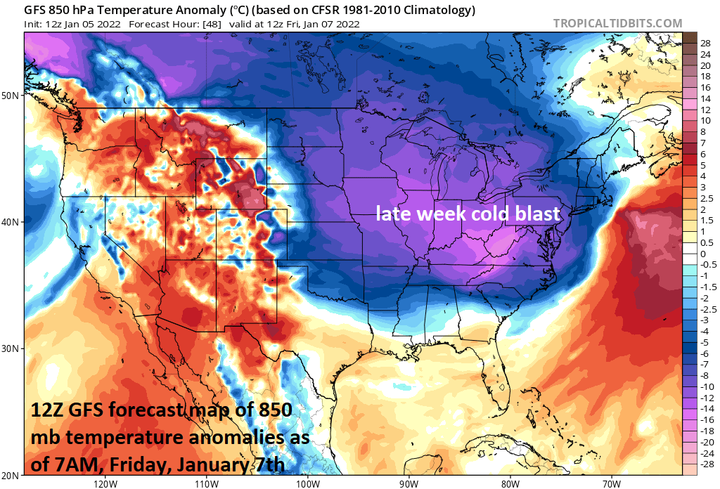
A cold air mass will push into the Mid-Atlantic region on Thursday following the passage of a cold front and any precipitation that falls on Thursday night and Friday in the DC-to-Philly-to-NYC corridor should be in the form of snow. Map courtesy NOAA, tropicaltidbits.com
Overview
Today will turn a little bit milder in the Mid-Atlantic region as low-level winds increase in intensity from a southwesterly direction ahead of the next cold frontal system. That cold front will shift to our east later tonight and its passage will usher in another cold air mass for the latter part of the week. On Thursday, an upper-level disturbance will help to spawn the formation of low pressure in the southeastern states and this system will intensify as it moves fairly quickly to the northeast reaching the waters off of Maine by mid-day Friday. Some accumulating snow will spread across the DC-to-Philly-to-NYC corridor on Thursday night and it’ll likely come to a quick end early Friday resulting in a moderate snowfall for the region. Temperatures are likely to drop to the teens on Friday night all along the I-95 corridor in the wake of the low pressure system and another cold air blast will arrive early next week into the Mid-Atlantic region.

This map shows snowfall amounts in the Mid-Atlantic/Northeast US for the winter so far. There is no “snow hole” this year in the DC metro region, but rather, the corridor from Philly-to-NYC-to-Boston has been missing out on all the action. Map courtesy NOAA
Details
High pressure has pushed off the east coast today and this will allow for slightly milder to push in this afternoon on increasingly strong SW winds out ahead of the next cold frontal system. That front will usher in a pretty impressive-looking cold air mass for the late week time period – just in time for the next low pressure system which will impact the region on Thursday night and early Friday.

This forecast map from a high-resolution model known as the HRRR features snow (blue shading) extending from the Delmarva-to-New England as of 4AM, Friday, January. Heavier snow bands are possible in this upcoming event along coastal sections of New Jersey , NYC and eastern New England (shown in dark blue). Map courtesy NOAA, weathermodels.com (Dr. Ryan Maue/Twitter)
An upper-level disturbance that is currently stretched-out across the western US will cross the nation rather quickly over the next 24 hours and arrive in the eastern states on Thursday night. This upper-level system will help to spin off a surface low pressure system early tomorrow in the Southeast US. This low pressure system will intensify tomorrow night as it pushes fairly quickly northeastward to a position off the Mid-Atlantic coastline by around midnight tomorrow night. After that, the system will continue to intensify and push to the northeast reaching the coastal waters of Maine by mid-day Friday.
Accumulating snow is likely to develop in the DC-to-Philly-to-NYC corridor later Thursday evening and, given the fairly rapid movement of the low pressure system, it is likely to wind down in the morning on Friday from southwest-to-northeast – perhaps a 8-12 hour event. As a result of the quick movement, the snowfall accumulations are likely to be on the relatively moderate side in the DC-Philly-NYC corridor with 3-6 inches an average range although isolated higher amounts are possible; especially,. across coastal sections of New Jersey and in the NYC metro region. Given the nature of the cold (and dry) air mass that will be in place during this upcoming event, the snow-to-liquid ratios are likely to be rather high resulting a drier, lighter texture to the snow as compared with the heavier, wet snow that fell earlier this week in the southern half of the Mid-Atlantic region.

Another cold blast is destined to arrive in the Mid-Atlantic/Northeast US early next week following a brief warm up on Sunday. Map courtesy NOAA, tropicaltidbits.com
Following the passage of the low pressure, temperatures are likely to drop well down into the teens on Friday night all along the I-95 corridor from DC-to-Philly-to-NYC. It’ll stay quite cold on Saturday, but milder air will push in for a brief time on Sunday. With the initial arrival of the milder air on Sunday, there can be some rain, ice or snow, but temperatures ultimately should climb into the 40’s – ahead of the next cold front. That next cold front will usher in another cold air mass for the Mid-Atlantic/Northeast US for the early part of next week and we can be dealing with more low temperatures in the teens - perhaps even in the single digits in some spots.
Still 24 hours or so to potentially tweak snowfall amounts so stay tuned.
Meteorologist Paul Dorian
Arcfield
arcfieldweather.com
Follow us on Facebook, Twitter, YouTube
Video discussion: