
1:30 PM | ***No rest for the weary in the Mid-Atlantic region…chance for some “black ice” late tonight…threat for ice/snow on Friday and a possible “freeze-up” on Friday night***
Paul Dorian

Icing is a threat for the Mid-Atlantic region on Friday as Arctic air slowly filters into the region from northwest-to-southeast. Map courtesy NOAA, Weather Bell Analytics
Overview
Tomorrow is Ground Hog Day and if I could provide some advice to my fellow Pennsylvania prognosticator, it would be to lean towards the prediction of 6 more weeks of winter. At least it is looking quite wintry for the next few weeks in much of the central and eastern US as cold air outbreaks will continue and there are likely to be multiple storm threats on the table. The next few days will feature a slow-moving Arctic cold frontal system across the nation’s heartland that will be the focus area for all kinds of precipitation. There will be rain and thunderstorms on the warm side of the front (southeast) and ice and snow on its cold side (northwest). In fact, the ice and snow will impact a large region of the country extending from the Southwest US to the Northeast US before the week is done with some regions likely to experience substantial snowfall and other areas to suffer with some serious icing.
In the Mid-Atlantic/Northeast US, Thursday will start off as a relatively mild day with some rainfall, but interior sections may begin to see a changeover to ice and/or snow later in the day as low-level Arctic air filters in. Sometime on Friday the rain can change to ice and/or snow in the immediate I-95 corridor with the arrival of the Arctic air and by Friday night, temperatures could be dropping rather sharply - potentially setting the stage for a quick “freeze-up”. Looking ahead and this is still in the speculation phase, another storm system is likely to develop near the Southeast US coastline early this weekend and it could result in some snow/ice in the Mid-Atlantic/NE US during the Sunday/Monday time frame.

There can be significant snow in a large part of the nation during the next few days extending from the southwestern states and southern Rockies all the way to the Northeast US. Map courtesy NOAA, Pivotal Weather
Details
The overall weather pattern looks to remain quite active during the next couple of weeks with multiple storm threats and also additional cold air outbreaks. In the near term, we won’t have to deal with any storms, but there actually can be some “black ice” late tonight/early Wednesday with the combination of damp, low-level air and below-freezing temperatures (i.e., moisture will freeze on untreated ground surfaces).

There can be significant icing in a large part of the nation during the next few days extending from Texas to the Northeast US. Map courtesy NOAA, Pivotal Weather
The big weather story over the next few days will be centered around the slow advancement of an Arctic air mass that will be supported by a very strong high pressure system dropping out of Canada and into the northern US. This strong Arctic high pressure is a key player in this unfolding scenario and the reason for my concern of icing in the Mid-Atlantic region at the end of the work week. The leading edge of this Arctic air mass will be an active frontal boundary zone that will feature rain and thunderstorms on its warm side (to the south and east) and ice and snow on its cold side (to the north and west) in the front edge of advancing Arctic cold, dense air mass. A large part of the nation will experience significant accumulating snow (e.g., St. Louis, Fort Wayne, Indianapolis, Chicago, Detroit) over the next few days and there will be a swath of substantial icing in other areas (e.g., Texas, Arkansas, Kentucky. In fact, the impact area associated with this slow-moving Arctic frontal system will stretch from the southwestern states to the Northeast US before the week is done.
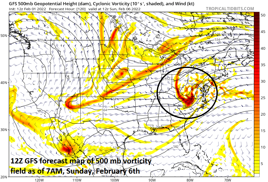
There is a chance that an upper-level wave of energy helps to spawn the formation of low pressure in the southeastern states this weekend…something to monitor for the Mid-Atlantic/NE US to see if it can push north with some snowfall in the Sunday/Monday time frame. Map courtesy NOAA, tropicaltidbits.com
In the Mid-Atlantic/Northeast US, Thursday may start off on the mild side with some rain, but as Arctic air filters into the interior sections, a changeover to ice and/or snow will likely take place. The low-level Arctic air will then reach into the immediate I-95 corridor during the day on Friday and this could result in a changeover of rain there to ice and/or snow. Whether this changeover results in a significant buildup of ice or an accumulation of snow in the Mid-Atlantic is still a bit too early to say, but it is certainly something to monitor over the next few days; especially, given the very strong Arctic high pressure system sitting just upstream. By Friday night, temperatures are likely to drop pretty sharply in the immediate I-95 corridor and this could result in a quick “freeze-up” - potentially leading to worsening road conditions.
Looking ahead, another strong wave of energy will drop into the southeastern states early this weekend. This system could help to spawn low pressure on Saturday that would have a chance of pushing northeast potentially bringing some snow or ice into the Mid-Atlantic/NE US in the Sunday/Monday time frame….something else to monitor in coming days.
Stay tuned…and we’ll see if Phil sees his shadow on Wednesday in Punxsutawney, Pennsylvania.
Meteorologist Paul Dorian
Arcfield
arcfieldweather.com
Follow us on Facebook, Twitter, YouTube
Video discussion: