
12:30 PM | ***Some accumulating snow likely late Saturday night into Sunday...very cold conditions to follow on Monday (Valentine's Day)...much warmer late next week***
Paul Dorian
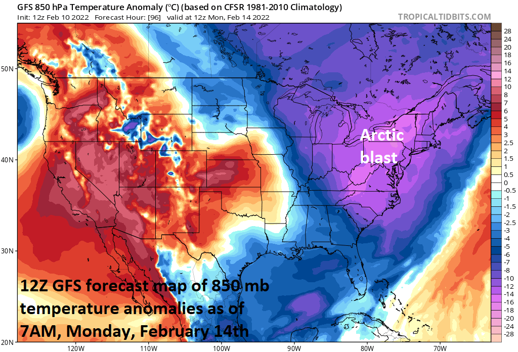
An Arctic blast arrives in the Mid-Atlantic on Sunday and it’ll remain quite cold through Tuesday. The core of the cold air mass will in the Mid-Atlantic region on Monday (Valentine’s Day) and temperatures will be way below-normal for the middle of February. Looking ahead, signs point to a big time warm-up by late next week in the eastern states. Map courtesy NOAA, tropicaltidbits.com
Overview
It stays mild in the Mid-Atlantic region into the beginning of the upcoming weekend, but an Arctic front will reach the area on Saturday and its passage will bring about much colder conditions for Sunday, Monday and Tuesday. Low pressure is likely to form along the Arctic frontal boundary zone by Saturday night and this system could generate some accumulating snowfall in the Mid-Atlantic region from late Saturday night into Sunday. The core of the Arctic blast will move into the region on Monday with temperatures on Valentine’s Day likely to be way below-normal for the middle of February. The Arctic chill wanes by mid-week and then signs point to a big time warm-up by late next week.

Low pressure will likely form along an Arctic frontal boundary zone later this weekend, but the “phasing” together of northern and southern systems may take place to late for any significant snow in the Mid-Atlantic. Map courtesy NOAA, tropicaltidbits.com
Details
After mild weather on Friday, the weekend will begin on the mild side; however, the arrival of an Arctic front on Saturday will set off some changes that will result in much colder conditions for Sunday, Monday and Tuesday. Temperatures may hold onto mild levels for at least part of the day on Saturday, but I wouldn’t be surprised if they drop some during the afternoon hours and dew points (a measure of overall moisture content) are quite likely to drop in the PM hours - quite typical of an incoming (dry, cold) Arctic air mass.

12Z GFS forecast map for early Sunday morning with snow (shown in blue) in parts of the Mid-Atlantic region. Map courtesy NOAA, tropicaltidbits.com
Low pressure will likely form along the Arctic frontal boundary zone by Saturday night and snow could break out late Saturday night in the I-95 corridor - perhaps as a brief period of rain at the onset. Snow can continue on Sunday morning before winding down as the low pressure system pushes northeastward to a position out over the western Atlantic Ocean.
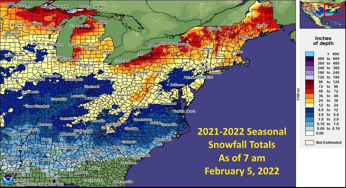
Total snowfall this winter season so far in the northeastern quadrant of the nation with a notable “snow hole” extending from suburbs to the north and west of Baltimore and Philly into the central part of Pennsylvania. According to NOAA, the month of January turned out to be the coldest since 2014 across the nation and also the driest in those same eight years. The average January temperature across the contiguous U.S. was 31 degrees (F), which ranks it in the middle-third of January months in the 128 year record. Data courtesy NOAA
In terms of snowfall amounts, it appears that accumulations will be on the moderate side - perhaps in the range of a coating to 2 or 3 inch range - with two limiting factors as it looks now. First, the “phasing'“ together of two upper-level waves of energy (one in the northern stream and one in the southern stream) looks like it just won’t happen quick enough for the development of a stronger low pressure system to impact the Mid-Atlantic region. Second, any low pressure system that does form is likely to move along rather quickly - inhibiting its chances for producing significant snow. There is still a few days to go before event time so we’ll continue to monitor the situation to see if this preliminary outlook deserves to be adjusted.
The core of this Arctic air mass will be fully entrenched in the Mid-Atlantic region by Monday following the departure of the low pressure system to the western Atlantic Ocean. As a result, Monday is liable to turn out to be much colder-than-normal for Valentine’s Day with high temperatures likely to be confined to the 20’s in many spots. [Normal high temperature now at Philly Intl Airport (PHL) is 43 degrees, at Reagan National Airport (DCA) is 47 degrees, and in Central Park (New York City) is 41 degrees]. It stays quite cold on Tuesday and then the Arctic chill begins to wane at mid-week. Looking beyond, there are strong signs that it’ll turn much warmer in the eastern states by late next week with well above-normal temperatures possible on Thursday and Friday.
Meteorologist Paul Dorian
Arcfield
arcfieldweather.com
Follow us on Facebook, Twitter, YouTube
Video discussion: